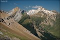
 view gallery view gallery W1.9 km W1.9 km
|   Pico Pacino (Huesca) Pico Pacino (Huesca)
in Vértices Geodésicos Vertice situado en el Pico Pacino, en Sallent de Gállego (Huesca) posted by:  jcast jcast location: Aragón, Spain date approved: 04/16/2006 last visited: never |
 view gallery view gallery S9.8 km S9.8 km
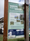
|  Camino de Santiago por El Alto Gállego, SANTA ELENA, Spain Camino de Santiago por El Alto Gállego, SANTA ELENA, Spain
in Way of St. James Way of St. James near a hermitage. posted by:  GEOrgCACHING GEOrgCACHING location: Aragón, Spain date approved: 06/05/2024 last visited: never |
 view gallery view galleryS10 km |  USTED ESTA AQUI - Santa Elena, Biescas, Spain USTED ESTA AQUI - Santa Elena, Biescas, Spain
in 'You Are Here' Maps Viewpoint posted by: GEOrgCACHING location: Aragón, Spain date approved: 06/03/2024 last visited: never |
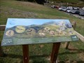
 view gallery view galleryS10 km | Ud. esta aqui - Línea P, fuerte Santa Elena, Spain in 'You Are Here' Maps Linea defensiva de los Pirineos posted by: GEOrgCACHING location: Aragón, Spain date approved: 06/02/2024 last visited: never |
 view gallery view galleryS10 km | UD. ESTÁ AQUI - Sta. Elena, Spain in 'You Are Here' Maps Hiking card posted by: GEOrgCACHING location: Aragón, Spain date approved: 06/07/2024 last visited: never |
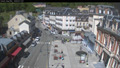
 view gallery view galleryS13.4 km |  Parking, Biescas, Spain Parking, Biescas, Spain
in Free Overnight RV Parking Locations Small city with a camperplace. posted by: GEOrgCACHING location: Aragón, Spain date approved: 06/10/2024 last visited: never |
 view gallery view galleryS13.4 km | Usted está aquí: BIESCAS, Spain in 'You Are Here' Maps Ski region posted by: GEOrgCACHING location: Aragón, Spain date approved: 06/02/2024 last visited: never |
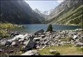 view gallery view gallery NE17.2 km NE17.2 km
|  Lac de Gaube / Gaube Lake - Pyrenees (France) Lac de Gaube / Gaube Lake - Pyrenees (France)
in Natural Lakes Small glacial Lac de Gaube (Gaube Lake), located close to the Pont d’Espagne in Pyrenees Mts., belongs among the most pictoresques lakes of the Pyrenees National Park... posted by: Dorcadion Team location: Occitanie, France date approved: 08/25/2014 last visited: 09/09/2023 |
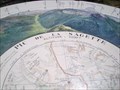 view gallery view gallery NW17.7 km NW17.7 km
|  Pic de la Sagette Pic de la Sagette
in Named Mountain Gaps Pic de la Sagette 2030 mètres. posted by: lulu_et_compagnie location: Nouvelle-Aquitaine, France date approved: 04/08/2022 last visited: 04/09/2022 |
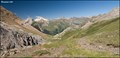 view gallery view gallery E21.1 km E21.1 km
|  Ara Valley from Puerto de Bujaruelo (Pyrennes Mts., Spain) Ara Valley from Puerto de Bujaruelo (Pyrennes Mts., Spain)
in Scenic Overlooks Beautiful vista over Ara valley in Aragonian part of Pyrenees Mts. you can find couple meters from French-Spain borders, in mountain pass called Puerto de Bujaruelo... posted by: Dorcadion Team location: Aragón, Spain date approved: 09/09/2009 last visited: 03/06/2014 |
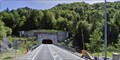 view gallery view galleryW21.2 km |  Tunnel du Somport - France/Espagne Tunnel du Somport - France/Espagne
in Border Crossings Entrée du tunnel du Somport à la fontière Franco-espagnole posted by: pilouille location: Pays de la Loire, France date approved: 04/02/2015 last visited: 06/23/2019 |
 view gallery view galleryE22 km | Col de Tentes - Refuge des Sarradets (Pyrennes Mts., France) in Scenic Hikes Short, but magnificent vistas offering trail from parking at Col de Tentes (2200 m) to Refuge des Sarradets (2600 m) in Pyrennes Mountains, is a perfect 1/2 day program for any mountains lover... posted by: Dorcadion Team location: Occitanie, France date approved: 06/26/2009 last visited: 08/01/2019 |
 view gallery view galleryNE22.5 km |  Webcam Cauterets (65) Webcam Cauterets (65)
in Web Cameras Webcam de Cauterets - Village posted by: JulieDavy location: Occitanie, France date approved: 05/31/2019 last visited: never |
 view gallery view galleryNE22.7 km |  Les Bains du Rocher - Cauterets (Hautes-Pyrénées), France Les Bains du Rocher - Cauterets (Hautes-Pyrénées), France
in Spas, Hammams, Mineral Baths and Saunas [FR] Les Bains du Rocher vous attendent à Cauterets dans un cadre grandiose et parfaitement intégré à la Nature. [EN] the Bains de Rocher spa proposes relaxation and wellbeing in an original and refined setting. posted by: RakeInTheCache location: Occitanie, France date approved: 05/21/2012 last visited: never |
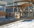 view gallery view gallery N23.2 km N23.2 km
|  Télécabine du Bézou - Gourette, Aquitaine/Pyrénées-Atlantiques, France Télécabine du Bézou - Gourette, Aquitaine/Pyrénées-Atlantiques, France
in Aerial Lifts Télécabine du Bézou posted by: pilouille location: Nouvelle-Aquitaine, France date approved: 04/01/2015 last visited: 09/04/2021 |
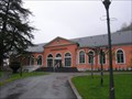
 view gallery view galleryN23.2 km |  Office de Tourisme Gourette - Eaux Bonnes, Nouvelle Aquitaine, France Office de Tourisme Gourette - Eaux Bonnes, Nouvelle Aquitaine, France
in Tourist Information Centers - Visitor Centers In the town center.
Dans le centre Ville. posted by: sara et gege location: Nouvelle-Aquitaine, France date approved: 09/19/2019 last visited: 12/31/2019 |
 view gallery view galleryN23.2 km |  Gourette - Aquitaine/Pyrénées-Atlantiques, France Gourette - Aquitaine/Pyrénées-Atlantiques, France
in Winter Sports Locations Station de ski Gourette posted by: pilouille location: Pays de la Loire, France date approved: 03/29/2015 last visited: 09/04/2021 |
 view gallery view galleryN23.3 km |  Mur escalade Gourette - Eaux Bonnes, Nouvelle Aquitaine, France Mur escalade Gourette - Eaux Bonnes, Nouvelle Aquitaine, France
in Artificial Climbing Walls In the town center
Dans le centre ville. posted by: sara et gege location: Nouvelle-Aquitaine, France date approved: 09/18/2019 last visited: 12/31/2019 |
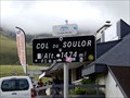 view gallery view galleryN23.8 km |  1474 m - col du Soulor - Arrens Marsous, Occitanie, France 1474 m - col du Soulor - Arrens Marsous, Occitanie, France
in Elevation Signs le col du Soulor posted by: sara et gege location: Occitanie, France date approved: 08/22/2019 last visited: 11/28/2019 |
 view gallery view galleryN23.8 km |  Col du Soulor - Arbeost, Occitanie, France Col du Soulor - Arbeost, Occitanie, France
in Wikipedia Entries the panels are at the neck of Soulor.
les panneaux sont au col du Soulor. posted by: sara et gege location: Occitanie, France date approved: 09/17/2019 last visited: 12/29/2019 |
 view gallery view galleryN23.8 km |  Col du Soulor site Natura 2000 - Arbeost, Occitanie, France Col du Soulor site Natura 2000 - Arbeost, Occitanie, France
in Flora and Fauna Information Signs the panels are at the neck of Soulor.
les panneaux sont au col du Soulor. posted by: sara et gege location: Occitanie, France date approved: 09/16/2019 last visited: 12/29/2019 |
 view gallery view galleryN23.8 km | Col du Soulor Faune, Arbeost, Occitanie, France in Flora and Fauna Information Signs The panels are at the neck of Soulor.
Les panneaux sont au col du Soulor. posted by: sara et gege location: Occitanie, France date approved: 09/16/2019 last visited: 12/29/2019 |
 view gallery view galleryN24 km | Col du Soulor Faune Migration, Arbeost, Occitanie, France in Flora and Fauna Information Signs The panels are at the neck of Soulor.
Les panneaux sont au col du Soulor. posted by: sara et gege location: Occitanie, France date approved: 09/16/2019 last visited: 12/29/2019 |
 view gallery view galleryN24 km |  Tyrolienne Deval Cable Col du Soulor - Arbeost, Occitanie, France Tyrolienne Deval Cable Col du Soulor - Arbeost, Occitanie, France
in Zip-line the zipline is at the neck of Soulor.
La tyrolienne est au col du Soulor. posted by: sara et gege location: Occitanie, France date approved: 09/19/2019 last visited: 12/29/2019 |
 view gallery view galleryN24 km | Col du Soulor Migrer, Arbeost, Occitanie, France in Flora and Fauna Information Signs the panels are at the neck of Soulor.
les panneaux sont au col du Soulor. posted by: sara et gege location: Occitanie, France date approved: 09/16/2019 last visited: 12/29/2019 |
|