 view gallery view gallery E8.7 km E8.7 km
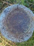
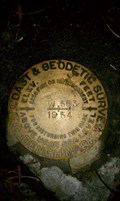
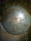
|   NZ0003 - USGS 'S' Pipe Cap - Klamath County, OR NZ0003 - USGS 'S' Pipe Cap - Klamath County, OR
in U.S. Benchmarks This NGS pipe cap is located in the backyard of a private residence just off Hwy 62 in Klamath County, OR. posted by:  NW_history_buff NW_history_buff location: Oregon date approved: 10/21/2013 last visited: never |
 view gallery view gallery NE8.9 km NE8.9 km
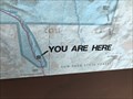
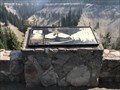
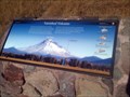
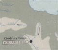
|  Crater Lake "You are here" - - Crater Lake, OR Crater Lake "You are here" - - Crater Lake, OR
in 'You Are Here' Maps A you are here at the entrance to Crater Lake National Park. posted by: saopaulo1 location: Oregon date approved: 08/13/2018 last visited: 11/27/2020 |
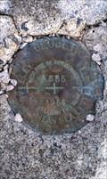
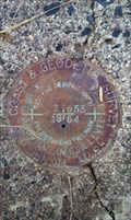 view gallery view galleryE9.8 km | NZ0016 - USC&GS 'Z 553' BM - Klamath County, OR in U.S. Benchmarks This NGS benchmark is located at the T-junction of Nicholson Rd and Hackler Rd, a couple of miles east of Fort Klamath, in Klamath County, OR. posted by: NW_history_buff location: Oregon date approved: 12/12/2012 last visited: never |
 view gallery view galleryNE10 km | NZ0005 - USGLO '111' Boundary Post - Klamath County, OR in U.S. Benchmarks This NGS boundary line post is located just off Hwy 62 within Crater Lake National Park in Klamath County, OR. posted by: NW_history_buff location: Oregon date approved: 10/21/2013 last visited: never |
 view gallery view galleryNE10 km |  Fossilized Steam - Crater Lake, OR Fossilized Steam - Crater Lake, OR
in Places of Geologic Significance A sign about the rock formation caused by steam. posted by: saopaulo1 location: Oregon date approved: 08/17/2018 last visited: never |
 view gallery view gallery SE10 km SE10 km
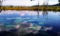
|  Mare's Egg Spring - Klamath County, OR Mare's Egg Spring - Klamath County, OR
in Natural Springs This natural spring located right off West Side Rd holds a secret treasure: it is home to a very rare type of fresh-water algae called 'mare's eggs' for which this spring bears its name. posted by: NW_history_buff location: Oregon date approved: 09/23/2013 last visited: never |
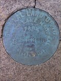
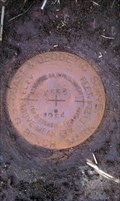
 view gallery view gallerySE10.3 km | NZ0017 - USC&GS 'A 555' - Klamath County, OR in U.S. Benchmarks This NGS benchmark is located along Hackler Rd, about a mile south of Nicholson Rd, in Klamath County, OR. posted by: NW_history_buff location: Oregon date approved: 12/12/2012 last visited: never |
 view gallery view gallery N10.5 km N10.5 km
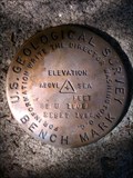
| USGS 'BBU 1908 RESET 1962' BM - Klamath County, OR in U.S. Benchmarks This RESET benchmark is located just off Hwy 62 within Crater Lake National Park in Klamath County, OR. posted by: NW_history_buff location: Oregon date approved: 10/21/2013 last visited: never |
 view gallery view gallerySE10.8 km | NZ0022 - USC&GS 'W 553' BM - Klamath County, OR in U.S. Benchmarks This NGS benchmark is located off Seven Mile Rd and about .1 mile west along USFS 770 Rd in Klamath County, OR. posted by: NW_history_buff location: Oregon date approved: 12/12/2012 last visited: never |
 view gallery view galleryE10.9 km | OSHD Nicholson Rd BM - Klamath County, OR in U.S. Benchmarks This benchmark is located on top of a concrete abutment over a creek along Nicholson Rd in Klamath County, OR. posted by: NW_history_buff location: Oregon date approved: 12/12/2012 last visited: never |
 view gallery view gallerySE11.1 km | NZ0018 - USC&GS 'B 555' BM - Klamath County, OR in U.S. Benchmarks This NGS benchmark is located along Hackler Rd, about two miles south of Nicholson Rd, in Klamath County, OR. posted by: NW_history_buff location: Oregon date approved: 12/12/2012 last visited: never |
 view gallery view galleryE11.4 km | NZ0015 - USC&GS 'Y 553' BM - Klamath County, OR in U.S. Benchmarks This NGS benchmark is located along Nicholson Rd., a mile east of Fort Klamath, in Klamath County, OR. posted by: NW_history_buff location: Oregon date approved: 12/12/2012 last visited: never |
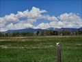
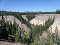
 view gallery view galleryE11.6 km |  Vanished Volcano - Klamath County, OR Vanished Volcano - Klamath County, OR
in Orientation Tables This roadside orientation table is located just off Hwy 62 and a few miles NW of Fort Klamath in Klamath County, OR. posted by: NW_history_buff location: Oregon date approved: 10/30/2013 last visited: never |
 view gallery view galleryE11.6 km |  Volcanic Legacy Scenic Byway - Mount Mazana - Fort Klamath, OR Volcanic Legacy Scenic Byway - Mount Mazana - Fort Klamath, OR
in National Scenic Byways The Volcanic Legacy Scenic Byway is a scenic highway and All-American Road in the U.S. states of California and Oregon. It is roughly 500 mi (804.7 km) long and travels north–south along the Cascade Range past numerous volcanoes. posted by: RakeInTheCache location: Oregon date approved: 06/01/2023 last visited: never |
 view gallery view galleryE11.6 km | Vanished Volcano Mount Mazama - Fort Klamath, OR in Places of Geologic Significance Mount Mazamais a complex volcano in the state of Oregon, United States, in a segment of the Cascade Volcanic Arc and Cascade Range. posted by: RakeInTheCache location: Oregon date approved: 06/01/2023 last visited: never |
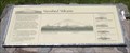 view gallery view galleryE11.6 km |  Vanished Volcano Vanished Volcano
in Oregon Historical Markers Geologic history sign titled Vanished Volcano, about formation of Crater Lake. posted by: Volcanoguy location: Oregon date approved: 11/04/2009 last visited: 11/27/2020 |
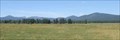 view gallery view galleryE11.6 km |  Vanished Volcano Viewpoint - Oregon Vanished Volcano Viewpoint - Oregon
in Scenic Roadside Look-Outs Viewpoint on Ore. Hwy. 62 west of Fort Klamath. posted by: Volcanoguy location: Oregon date approved: 11/06/2009 last visited: 10/19/2013 |
 view gallery view galleryN12.2 km | NZ0008 - USGS '5839' BM - Klamath County, OR in U.S. Benchmarks This NGS benchmark is located just off Hwy 62 within Crater Lake National Park in Klamath County, OR. posted by: NW_history_buff location: Oregon date approved: 10/21/2013 last visited: never |
 view gallery view galleryE13.2 km |  Fort Klamath Elementary School - Fort Klamath, OR Fort Klamath Elementary School - Fort Klamath, OR
in Former Schools This former elementary school is located along Nicholson Rd. just west of Fort Klamath, OR. posted by: NW_history_buff location: Oregon date approved: 12/06/2012 last visited: never |
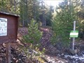 view gallery view gallery S13.5 km S13.5 km
|  Nannie Creek Trailhead - Klamath County, OR Nannie Creek Trailhead - Klamath County, OR
in Hiking and walking trailheads Annie Creek Trailhead is a nice trail within the Sky Lakes Wilderness area and located east of West Side Rd in Klamath County, OR. posted by: NW_history_buff location: Oregon date approved: 10/07/2013 last visited: never |
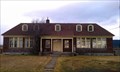
 view gallery view galleryE13.7 km |  Fort Klamath Hotel - Fort Klamath, OR Fort Klamath Hotel - Fort Klamath, OR
in Photos Then and Now This former hotel is located in the town of Fort Klamath, OR. posted by: NW_history_buff location: Oregon date approved: 12/07/2012 last visited: never |
 view gallery view galleryN13.7 km | Fossil Fumaroles Viewpoint - Oregon in 'You Are Here' Maps You Are Here Map at viewpoint on Ore. Hwy. 62 in Crater Lake National Park. posted by: Volcanoguy location: Oregon date approved: 11/05/2009 last visited: 08/25/2009 |
 view gallery view galleryN13.7 km | Fossil Fumaroles Viewpoint - Oregon in Scenic Roadside Look-Outs Viewpoint on Ore. Hwy. 62 in Crater Lake National Park. posted by: Volcanoguy location: Oregon date approved: 11/06/2009 last visited: 11/27/2020 |
 view gallery view galleryN13.7 km | Fossil Fumaroles in Oregon Historical Markers Geologic history sign about the formation of fossil fumaroles along Annie Creek. posted by: Volcanoguy location: Oregon date approved: 11/04/2009 last visited: 11/27/2020 |
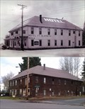
 view gallery view galleryE13.7 km | The Town of Fort Klamath Historical Marker - Fort Klamath, OR in Oregon Historical Markers This historical 'T' marker is located in Fort Klamath in front of a historic social center building. posted by: NW_history_buff location: Oregon date approved: 12/07/2012 last visited: never |
|