 view gallery view gallery SW2.3 km SW2.3 km
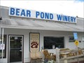
|   Bear Pond Winery Bear Pond Winery
in Wineries Small upstate New York Winery established in 1999. Nestled on a gentle hillside in the heart of the Leatherstocking Region of New York State. Near the home of baseball! posted by:  jpaz62 jpaz62 location: New York date approved: 07/12/2009 last visited: never |
 view gallery view gallery SE2.4 km SE2.4 km
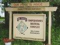
|  Cooperstown Brewing Co Cooperstown Brewing Co
in Breweries Small brewery in the home of Baseball. Tasting sales and tour. Part of the Cooperstown Beverage Trail. posted by: jpaz62 location: New York date approved: 07/13/2009 last visited: never |
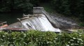 view gallery view gallerySW3.4 km |  Collier's Dam - Colliersville, NY Collier's Dam - Colliersville, NY
in Water Dams The dam was created to generate power, by damming the Susquehanna River. Goodyear Lake was created and now there are property owners with an interest in the recreational value of the lake. posted by:  ripraff ripraff location: New York date approved: 08/07/2017 last visited: never |
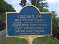 view gallery view gallerySW3.4 km |  Collier's Dam Collier's Dam
in New York Historical Markers A New York state historical Marker on highway 28 south of Cooperstown. posted by: heringermr location: New York date approved: 06/27/2009 last visited: 08/06/2017 |
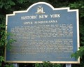 view gallery view gallery S3.9 km S3.9 km
| Historic New York Upper Susquehanna - Cooperstown Junction, New York in New York Historical Markers This sign is at a small parking area on route 992G, a connector between route 28 and route 7.
Cooperstown Junction is near Oneonta. posted by: ripraff location: New York date approved: 08/01/2017 last visited: never |
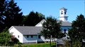
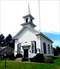 view gallery view galleryS4.2 km |  UM Church - Cooperstown Junction, NY UM Church - Cooperstown Junction, NY
in This Old Church Cooperstown Junction UMC is in the Oneonta District of the Upper New York Conference of the United Methodist Church. posted by: ripraff location: New York date approved: 08/02/2017 last visited: never |
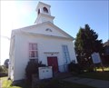
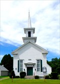 view gallery view galleryS4.2 km |  Cooperstown Junction United Methodist Church - Cooperstown Junction, NY Cooperstown Junction United Methodist Church - Cooperstown Junction, NY
in Methodist Churches Cooperstown Junction UMC is in the Oneonta District of the Upper New York Conference of the United Methodist Church. posted by: ripraff location: New York date approved: 10/14/2017 last visited: never |
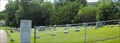
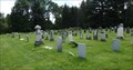 view gallery view galleryS4.2 km |  Cooperstown Junction Cemetery - Cooperstown Junction, NY Cooperstown Junction Cemetery - Cooperstown Junction, NY
in Worldwide Cemeteries This cemetery is across the road from the Methodist Church (dated 1876). posted by: ripraff location: New York date approved: 08/05/2017 last visited: never |
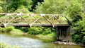 view gallery view galleryS4.3 km |  Cooperstown Junction, NY Cooperstown Junction, NY
in Truss Bridges "Abandoned warren pony truss with alternating verticals bridge over Schenevus Creek on Abandoned road" posted by: ripraff location: New York date approved: 08/04/2017 last visited: never |
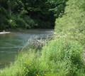 view gallery view galleryS4.5 km |  Schenevus Creek - Robert V. Riddell State Park, Davenport, NY Schenevus Creek - Robert V. Riddell State Park, Davenport, NY
in Fishing Holes Robert V. Riddell State Park has "Schenevus Creek, a Class A trout stream which leads to the Susquehanna River, crosses the north side of the park. " posted by: ripraff location: New York date approved: 07/03/2016 last visited: never |
 view gallery view gallerySE4.5 km | Spencer Cemetery in Worldwide Cemeteries This old cemetery can be found on Route 7 between Oneonta and Otego, New York. posted by: JuneNY location: New York date approved: 07/25/2011 last visited: never |
 view gallery view galleryS4.5 km |  Jett Industries, Inc. - Colliersville, NY Jett Industries, Inc. - Colliersville, NY
in Flags of Organizations Jett Industries, Inc. is a general contractor constructing and modifying water and wastewater treatment facilities. posted by: ripraff location: New York date approved: 08/01/2017 last visited: never |
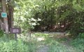
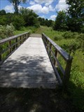 view gallery view galleryS4.8 km |  Scout bridge - Robert V. Riddell State Park, Davenport, NY Scout bridge - Robert V. Riddell State Park, Davenport, NY
in Hiking Path Footbridges There are two bridges on the trails on the north section of the park (north of route 88). posted by: ripraff location: New York date approved: 07/06/2016 last visited: never |
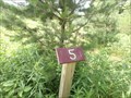 view gallery view galleryS5 km |  Tree Identification Trail - Robert V. Riddell State Park, Davenport, NY Tree Identification Trail - Robert V. Riddell State Park, Davenport, NY
in Self Guided Walks and Trails This trail is 1.32 miles, around the northern section of the park. A few of the posts are not at the places marked on the map. The map is online and is well done. This is a scout project. posted by: ripraff location: New York date approved: 07/04/2016 last visited: never |
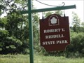 view gallery view galleryS5 km |  Robert V. Riddell State Park - Davenport, NY Robert V. Riddell State Park - Davenport, NY
in State/Provincial Parks "The park is easily accessible, straddling I-88 in Otsego County," Day use only, Dawn until Dusk posted by: ripraff location: New York date approved: 07/03/2016 last visited: never |
 view gallery view galleryS5.5 km |  Trail to Mud Lake - Robert V. Riddell State Park, Davenport, NY Trail to Mud Lake - Robert V. Riddell State Park, Davenport, NY
in Hiking and walking trailheads The southern part of this park has trails that can be reached by parking on the side of the road and using the trailhead. posted by: ripraff location: New York date approved: 07/03/2016 last visited: never |
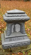 view gallery view gallerySW6.8 km |  Murdock Family - Hartwick, NY Murdock Family - Hartwick, NY
in Zinc Headstones Located in
The Maples Cemetery
Hartwick
Otsego County
New York posted by: bhouston21 location: New York date approved: 11/09/2011 last visited: never |
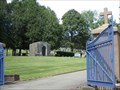 view gallery view gallerySW8 km | Mount Calvary Cemetery - Emmons, NY in Worldwide Cemeteries This large cemetery has a blue gate and a sign. There is an area with a statue of Mary. posted by: ripraff location: New York date approved: 08/06/2017 last visited: never |
 view gallery view gallerySW8 km | Temple Beth El Cemetery - Emmons, NY in Worldwide Cemeteries This cemetery is next to Mount Calvary Cemetery in Emmons, near Oneonta, NY. It has a fence and a sign. It is a lawn, no shrubs or trees. There are trees behind the cemetery. posted by: ripraff location: New York date approved: 08/06/2017 last visited: never |
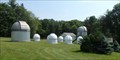 view gallery view gallerySW8.5 km |  SUNY Oneonta College Observatory - Oneonta, NY SUNY Oneonta College Observatory - Oneonta, NY
in Astronomical Observatories This is on a hill near the campus next to the college camp. posted by: ripraff location: New York date approved: 06/29/2018 last visited: never |
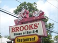 view gallery view gallerySW9 km |  Brooks' Barbecue, Oneonta, New York Brooks' Barbecue, Oneonta, New York
in Artistic Neon Lights Cook with hatchet chasing chicken at Brooks' BBQ. posted by: LeoGeo location: New York date approved: 08/10/2009 last visited: 07/06/2018 |
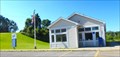
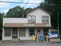 view gallery view galleryS9.3 km |  West Davenport, N.Y. 13860 West Davenport, N.Y. 13860
in U.S. Post Offices West Davenport, Delaware County, New York 13860. posted by: LeoGeo location: New York date approved: 08/10/2009 last visited: never |
 view gallery view gallery W9.8 km W9.8 km
| Christian Church - Laurens, NY in This Old Church The Christian Church was organized in 1836 and built a church in 1837 (for 800 dollars). In 1930 it was bought by Danish settlers. The church is now St. Mathew's Lutheran Church. posted by: ripraff location: New York date approved: 08/11/2017 last visited: never |
 view gallery view galleryW9.8 km | St. Mathews Lutheran Church - Laurens, NY in Lutheran Churches This church has established 1915 on one of its signs. The full church can be seen from the post office parking lot. posted by: ripraff location: New York date approved: 08/03/2017 last visited: never |
 view gallery view galleryW9.8 km | Laurens, NY 13796 in U.S. Post Offices The name of the village and zipcode are on the glass window of the door in white. They are not on the building itself. posted by: ripraff location: New York date approved: 08/07/2017 last visited: never |
|