 view gallery view gallery NE20.4 km NE20.4 km
|   Devils Gate Devils Gate
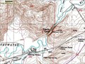
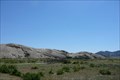
in Geological Devilish Locations Devil's Gate is a gap in the Sweetwater Rocks located southwest of Casper, WY. The coordinates are for the rest area west of the Devil's Gap. This is a place where the feature can be safely viewed. posted by:  Team Min Dawg Team Min Dawg location: Wyoming date approved: 03/04/2007 last visited: 09/07/2019 |
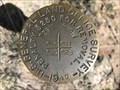 view gallery view galleryNE26.6 km |  T29N R86W S20 S21 S28 S29 - Natrona County, Wyoming T29N R86W S20 S21 S28 S29 - Natrona County, Wyoming
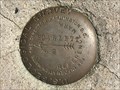
in Public Land Survey Marks This GLO section corner marker is on the northwest side of Sentinel Rocks in southern Natrona County. posted by:  Tom.dog Tom.dog location: Wyoming date approved: 05/08/2023 last visited: never |
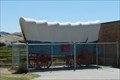 view gallery view galleryNE29.1 km |  Independence Rock Wagon - Wyoming Independence Rock Wagon - Wyoming
in Covered Wagons This wagon is located at the Independence Rock State Historic Site, an important location along the Oregon Trail. posted by: Hikenutty location: Wyoming date approved: 07/20/2007 last visited: 07/24/2012 |
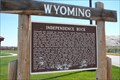 view gallery view galleryNE29.3 km |  Independence Rock - Wyoming Independence Rock - Wyoming
in Wyoming Historical Markers This location was famous along the Oregon trail as a place to inscribe your name as you passed by. Many emmigrants left home in the spring, hoping to make it to Independence Rock by July 4th, when people on the trail would gather for a party. posted by: Hikenutty location: Wyoming date approved: 07/20/2007 last visited: 09/07/2019 |
 view gallery view galleryNE29.5 km |  Independence Rock - Wyoming Independence Rock - Wyoming
in American Guide Series This location was famous along the Oregon trail as a place to inscribe your name as you passed by. Many emmigrants left home in the spring, hoping to make it to Independence Rock by July 4th, when people on the trail would gather for a party. posted by: Hikenutty location: Wyoming date approved: 09/07/2007 last visited: 09/07/2019 |
 view gallery view galleryNE29.5 km |  Oregon Trail - Independence Rock - Wyoming Oregon Trail - Independence Rock - Wyoming
in Wagon Roads and Trails This location was famous along the Oregon trail as a place to inscribe your name as you passed by. Many emmigrants left home in the spring, hoping to make it to Independence Rock by July 4th, when people on the trail would gather for a party. posted by: Hikenutty location: Wyoming date approved: 07/19/2007 last visited: 09/07/2019 |
 view gallery view galleryNE29.5 km |  Independence Rock - Wyoming Independence Rock - Wyoming
in U.S. National Register of Historic Places This location was famous along the Oregon trail as a place to inscribe your name as you passed by. Many emmigrants left home in the spring, hoping to make it to Independence Rock by July 4th, when people on the trail would gather for a party.
posted by: Hikenutty location: Wyoming date approved: 07/19/2007 last visited: 09/07/2019 |
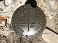
 view gallery view galleryNE30.6 km | T30N R87W S10 S11 1/4 - Natrona County, Wyoming in Public Land Survey Marks This GLO quarter corner marker is located just east of the crest of a ridge in the northeastern Granite Mountains. posted by: Tom.dog location: Wyoming date approved: 05/08/2023 last visited: never |
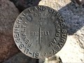
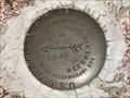
 view gallery view galleryNE33.8 km |  16 PHJ - Natrona County, Wyoming 16 PHJ - Natrona County, Wyoming
in U.S. Benchmarks A USGS benchmark set to the northeast of a bend in County Road 321 (Dry Creek Road). posted by: Tom.dog location: Wyoming date approved: 05/08/2023 last visited: never |
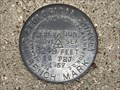
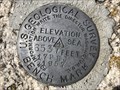
 view gallery view galleryNE34.3 km | 2 PHJ - Natrona County, Wyoming in U.S. Benchmarks A U.S. Geological Survey benchmark on the southwest side of County Road 321 (Dry Creek Road). posted by: Tom.dog location: Wyoming date approved: 05/08/2023 last visited: never |
 view gallery view galleryNE34.3 km | ROCKY NO 2 - Natrona County, Wyoming in U.S. Benchmarks Reference mark 2 for USGS benchmark ROCKY. posted by: Tom.dog location: Wyoming date approved: 05/08/2023 last visited: never |
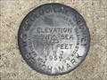
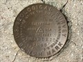
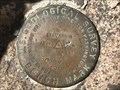 view gallery view galleryNE34.3 km | ROCKY (NR0403) - Natrona County, Wyoming in U.S. Benchmarks This U.S. Geological Survey benchmark is set near the top of an unnamed summit in the northeastern Granite Mountains. posted by: Tom.dog location: Wyoming date approved: 05/08/2023 last visited: never |
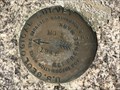 view gallery view galleryNE34.3 km | ROCKY NO 1 - Natrona County, Wyoming in U.S. Benchmarks Reference mark 1 for USGS benchmark ROCKY. posted by: Tom.dog location: Wyoming date approved: 05/08/2023 last visited: never |
 view gallery view galleryNE34.9 km | 17 PHJ - Natrona County, Wyoming in U.S. Benchmarks A U.S. Geological Survey benchmark on the south side of County Road 321/Dry Creek Road. posted by: Tom.dog location: Wyoming date approved: 05/08/2023 last visited: never |
  NW35.2 km NW35.2 km
|  Jeffrey City, Wyoming Jeffrey City, Wyoming
in Ghost Towns Jeffrey City, Wyoming isn't your usual ghost town. What sets it apart is its age- the town was founded in 1931, grew to 4,500 people by 1978, and by 1993 had nearly been abandoned. posted by: DavidMac location: Wyoming date approved: 02/11/2006 last visited: 10/25/2015 |
 view gallery view galleryNE35.6 km | T30N R86W S23 S24 S25 S26 - Natrona County, Wyoming in Public Land Survey Marks A GLO section corner marker to the northeast of County Road 321 (Dry Creek Road). posted by: Tom.dog location: Wyoming date approved: 05/08/2023 last visited: never |
 view gallery view gallery W59.1 km W59.1 km
| SCARLETT 2 - Fremont County, Wyoming in U.S. Benchmarks Reference mark 2 for USGS benchmark SCARLETT (NS0158). posted by: Tom.dog location: Wyoming date approved: 08/27/2023 last visited: never |
 view gallery view galleryW59.1 km | SCARLETT 1 - Fremont County, Wyoming in U.S. Benchmarks Reference mark 1 for USGS benchmark SCARLETT (NS0158). posted by: Tom.dog location: Wyoming date approved: 08/27/2023 last visited: never |
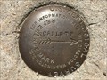
 view gallery view galleryW59.1 km | SCARLETT (NS0158) - Fremont County, Wyoming in U.S. Benchmarks A USGS benchmark on top of a low hill that overlooks the Sweetwater River. posted by: Tom.dog location: Wyoming date approved: 08/27/2023 last visited: never |
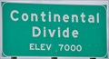 view gallery view gallery S64.2 km S64.2 km
|  Interstate 80 Eastbound - Continental Divide ~ Elevation 7000 Interstate 80 Eastbound - Continental Divide ~ Elevation 7000
in Elevation Signs This sign is located at the point where Interstate crosses the eastern branch of the Continental Divide after it splits to form the Great Divide Basin. posted by: brwhiz location: Wyoming date approved: 09/05/2012 last visited: 05/14/2021 |
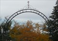
 view gallery view galleryS65 km |  St. Joseph's Cemetery Arch - Rawlins WY St. Joseph's Cemetery Arch - Rawlins WY
in Freestanding Arches This Arch is at the entrance to St. Josephs Cemetery is on 3rd Street at West Murray Stteet in Rawlins, Wyoming. posted by: PeterNoG location: Wyoming date approved: 11/20/2016 last visited: 09/03/2018 |
 view gallery view galleryS65 km |  St Josephs Cemetery - Rawlins WY St Josephs Cemetery - Rawlins WY
in Worldwide Cemeteries This Cemetery is on 3rd Street at West Murray Street in Rawlins, Wyoming. posted by: PeterNoG location: Wyoming date approved: 11/09/2016 last visited: 04/15/2023 |
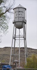 view gallery view galleryS65.5 km | USCGS MP0612 ~ RAWLINS WATER TANK in U.S. Benchmarks This USCGS Survey Point is the top center point of the 100-foot tall water tank located on the grounds of the historic Wyoming State Penitentiary in Rawlins. posted by: brwhiz location: Wyoming date approved: 09/23/2012 last visited: 06/21/2024 |
 view gallery view galleryS65.5 km |  Wyoming State Penitentiary Water Tower Wyoming State Penitentiary Water Tower
in Water Towers This water tower is located on the grounds of the historic Wyoming State Penitentiary in Rawlins, Wyoming. posted by: brwhiz location: Wyoming date approved: 09/24/2012 last visited: 06/21/2024 |
 view gallery view galleryS65.5 km |  Wyoming Frontier Prison Museum - Rawlins, WY Wyoming Frontier Prison Museum - Rawlins, WY
in Roadside Attractions The Wyoming Frontier Prison is a guided tour. posted by: mr.volkswagen location: Wyoming date approved: 07/09/2024 last visited: never |
|