 view gallery view gallery NW0.2 km NW0.2 km
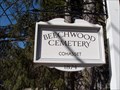
|   Beechwood Cemetery - Cohasset, MA Beechwood Cemetery - Cohasset, MA
in Worldwide Cemeteries There are about 2,000 graves here. For more than two centuries Beechwood Cemetery was privately owned; today it is a municipal cemetery. posted by:  RIclimber RIclimber location: Massachusetts date approved: 04/11/2010 last visited: 05/08/2010 |
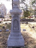
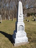 view gallery view galleryNW0.2 km |  Ziba Wood - Beechwood Cem. Cohasset, MA Ziba Wood - Beechwood Cem. Cohasset, MA
in Zinc Headstones If it's rare to find a Zinc headstone, then it must be Very rare to find one in your family! Ziba Wood is my 5x Great Grandfather. posted by: RIclimber location: Massachusetts date approved: 03/22/2010 last visited: 05/25/2010 |
 view gallery view gallery SE1.1 km SE1.1 km
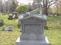
| Frederick A. Litchfield in Zinc Headstones This small zinc stone is in Mt. Hope Cemetery. posted by: RIclimber location: Massachusetts date approved: 03/25/2010 last visited: 04/04/2010 |
 view gallery view gallery W1.1 km W1.1 km
|  Wompatuck State Park - South Shore, MA Wompatuck State Park - South Shore, MA
in Geocaching Tour Guides If anyone ever needs help in Wompatuck State Park, give me a call!
posted by: RIclimber location: Massachusetts date approved: 01/11/2010 last visited: 01/17/2010 |
 view gallery view gallery SW1.3 km SW1.3 km
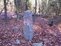
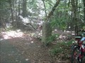
|  Cohasset, Hingham, and Scituate Corner Cohasset, Hingham, and Scituate Corner
in U.S. Historic Survey Stones and Monuments Located in Wompatuck State Park at the corner of Cohasset, Hingham, and Scituate. posted by: RIclimber location: Massachusetts date approved: 01/03/2010 last visited: 10/20/2012 |
 view gallery view galleryW1.3 km | Hingham-Cohasset MA boundry in U.S. Historic Survey Stones and Monuments A granite post marking the boundry between the towns of Hingham and Cohassett, MA posted by: STEMARTHON location: Massachusetts date approved: 09/19/2010 last visited: never |
 view gallery view galleryW1.8 km | Hingham Cohasset Border A in U.S. Historic Survey Stones and Monuments Stone Pillar marking the Hingham - Cohasset town border corner posted by: STEMARTHON location: Massachusetts date approved: 09/19/2010 last visited: never |
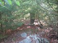
 view gallery view gallerySW2.3 km |  Mt. Blue Spring - Wompatuck State Park, Hingham, MA Mt. Blue Spring - Wompatuck State Park, Hingham, MA
in Spring Houses Mt. Blue Spring was first bottled in the mid 1800's and was forced to stop in the 1940's when the US Army took over the land to create the Hingham Naval Ammunition Depot Annex. The spring is now in Wompatuck State Park, and is free for everyone posted by: RIclimber location: Massachusetts date approved: 03/10/2010 last visited: 08/31/2012 |
 view gallery view gallery NE2.9 km NE2.9 km
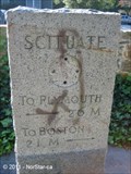
|  Scituate Monument - Boston and Plymouth - Scituate, MA Scituate Monument - Boston and Plymouth - Scituate, MA
in Direction and Distance Arrows This stone marker is located along Country Way in Scituate, not far from the town line with Cohasset, and it contains the miles and directions to Boston and Plymouth. posted by:  NorStar NorStar location: Massachusetts date approved: 11/13/2011 last visited: never |
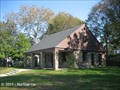 view gallery view gallery E2.9 km E2.9 km
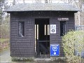
|  North Scituate WPA Building - Scituate, MA North Scituate WPA Building - Scituate, MA
in WPA Projects This pretty stone structure that was built by the WPA in 1937-8 sits in a small park at near the center of the village of North Scituate. posted by: NorStar location: Massachusetts date approved: 11/13/2011 last visited: never |
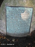 view gallery view galleryNE2.9 km |  Tablet Near Bound Rock - Scituate-Cohasset, MA Tablet Near Bound Rock - Scituate-Cohasset, MA
in Massachusetts Historical Markers This bronze tablet along Country Way straddles the line between Scituate and Cohasset, which also is the border between Norfolk and Plymouth Counties, but it was originally set to mark the boundary between Massachusetts Bay and Plymouth Colonies. posted by: NorStar location: Massachusetts date approved: 11/21/2011 last visited: never |
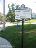 view gallery view galleryE2.9 km | Gannett's Corner - Scituate, MA in Massachusetts Historical Markers This village of Scituate was settled by Matthew Gannett in 1651. posted by: NorStar location: Massachusetts date approved: 11/21/2011 last visited: never |
 view gallery view galleryE2.9 km |  'Marylou's, North Scituate - Scituate, MA 'Marylou's, North Scituate - Scituate, MA
in Independent Coffee Shops This shop is one of several Marylou's in southeastern Massachusetts and Rhode Island, which feature many choices in flavored coffee items - plus, it's very PINK. posted by: NorStar location: Massachusetts date approved: 11/15/2011 last visited: never |
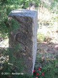 view gallery view galleryNE2.9 km | C-S-6 WM - Cohasset-Scituate 6 Witness Mark in U.S. Historic Survey Stones and Monuments This stone monument is a witness mark that defines the boundary of Cohasset and Scituate, but it also is near where Bound Rock was located, which began a line that defined the boundary between Plymouth and Massachusetts Bay Colonies. posted by: NorStar location: Massachusetts date approved: 11/13/2011 last visited: never |
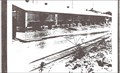
 view gallery view galleryE2.9 km |  North Scituate Railroad Depot - Scituate, MA North Scituate Railroad Depot - Scituate, MA
in Train Stations/Depots The North Scituate railroad depot is now part of a strip mall, but the building still has the general appearance of a station, including a train canopy that extends behind and off the side. posted by: NorStar location: Massachusetts date approved: 11/14/2011 last visited: never |
 view gallery view galleryNE2.9 km |  Mordecai Lincoln Mill - Scituate-Cohassett, MA Mordecai Lincoln Mill - Scituate-Cohassett, MA
in Water Mills According to a sign next to this mill, Mordecai Lincoln, Abraham Lincoln's great-great-great grandfather, built this mill in 1691-2. posted by: NorStar location: Massachusetts date approved: 11/13/2011 last visited: never |
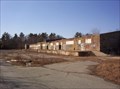
 view gallery view galleryNW3.2 km |  Hingham Naval Ammunition Depot Annex Hingham Naval Ammunition Depot Annex
in Photos Then and Now This is the "Ballistite Grain Inhibiting Building" in the "Hingham Annex", now Wompatuck State Park. posted by: RIclimber location: Massachusetts date approved: 11/13/2009 last visited: 11/27/2009 |
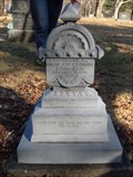
 view gallery view galleryE3.5 km | JOSEPH H. BROWN - Groveland Cemetery, SCITUATE, MA in Zinc Headstones In Groveland Cemetery. posted by: RIclimber location: Massachusetts date approved: 03/22/2010 last visited: 05/25/2010 |
 view gallery view galleryE3.5 km | Capt. Hiram Newcomb - Groveland Cemetery, SCITUATE, MA in Zinc Headstones In Groveland Cemetery. This is one of the most interesting zinc markers I've ever seen. There is a large anchor and chain on top, 3 foot stones, and four corner stones. posted by: RIclimber location: Massachusetts date approved: 05/09/2010 last visited: 05/25/2010 |
 W3.7 km |  Wompatuck State Park Campground Wompatuck State Park Campground
in Campgrounds Camping in a Mass. State forest posted by: manometchapterchief04 location: Massachusetts date approved: 03/30/2006 last visited: 05/13/2012 |
 view gallery view galleryW3.7 km |  Wompatuck State Park Wompatuck State Park
in Wikipedia Entries A State Park of MASS posted by: manometchapterchief04 location: Massachusetts date approved: 03/30/2006 last visited: 09/23/2012 |
 view gallery view galleryW3.7 km |  Wompatuck State Park Wompatuck State Park
in Military Installations Old WWII Ammo Depot now a State Park posted by: manometchapterchief04 location: Massachusetts date approved: 03/30/2006 last visited: 03/15/2012 |
 view gallery view gallery N3.9 km N3.9 km
|  First Parish Meeting House - Unitarian - Cohasset MA First Parish Meeting House - Unitarian - Cohasset MA
in This Old Church Started in the development stage and substantially completed in October 1747. posted by: nomadwillie location: Massachusetts date approved: 07/01/2014 last visited: never |
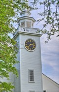 view gallery view galleryN3.9 km |  First Parish Meeting House - Cohasset MA First Parish Meeting House - Cohasset MA
in Town Clocks The clock was given to the town in 1864 and installed in the steeple. posted by: nomadwillie location: Massachusetts date approved: 07/04/2014 last visited: never |
 view gallery view galleryN3.9 km |  Cohasset, MA Cohasset, MA
in City and Town Halls In 1857 Cohasset built a new Town Hall to be used as meeting place and a school. posted by: nomadwillie location: Massachusetts date approved: 07/02/2014 last visited: never |
|