 view gallery view gallery N0.2 km N0.2 km
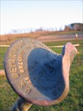
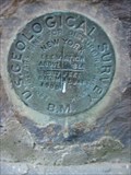
|   US Dept. Interior Geological Survey - 27 CRH - Johnson City, NY US Dept. Interior Geological Survey - 27 CRH - Johnson City, NY
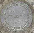
in U.S. Benchmarks US Department of Interior Geological Survey Disk 27 CRH (1492 FT) in Johnson City, NY at the Southeast corner of the intersection of East Maine Road and Commercial Drive. posted by:  RazorbackFan RazorbackFan location: New York date approved: 05/13/2007 last visited: never |
 view gallery view gallery S0.3 km S0.3 km
|  East Maine Fire Co. East Maine Fire Co.
in Firehouses "The East Maine Fire Company (EMFC) was founded and Incorporated as a non-profit organization in 1948." posted by:  ripraff ripraff location: New York date approved: 06/22/2015 last visited: never |
 view gallery view gallery NE1.1 km NE1.1 km
|  Weather Radar - Airport, Binghamton, NY Weather Radar - Airport, Binghamton, NY
in Weather Radars The radar can be seen from Commercial Drive or from the Greater Binghamton Airport. posted by: ripraff location: New York date approved: 11/01/2016 last visited: never |
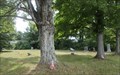
 view gallery view galleryS1.3 km |  East Maine Cemetery - East Maine, NY East Maine Cemetery - East Maine, NY
in Worldwide Cemeteries East Maine Cemetery is also known as Bucks Knob Cemetery posted by: ripraff location: New York date approved: 06/09/2015 last visited: never |
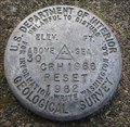
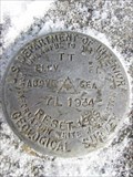 view gallery view galleryN1.6 km | TT 7 L 1934 RESET 1969 - Johnson City, NY in U.S. Benchmarks U.S. Department of Interior Geological Survey Disk TT 7L (1328) located in Johnson City, NY near the intersection of Arbutus Road and East Maine Road. posted by: RazorbackFan location: New York date approved: 01/25/2007 last visited: 06/27/2015 |
 view gallery view galleryNE1.9 km |  Greater Binghamton Airport - Binghamton, NY Greater Binghamton Airport - Binghamton, NY
in Airports Greater Binghamton Airport was named Edwin A. Link Field for awhile and the field still has that name posted by: ripraff location: New York date approved: 06/27/2015 last visited: 03/26/2023 |
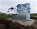 view gallery view galleryNE2.1 km |  Globe - Greater Binghamton Airport, NY Globe - Greater Binghamton Airport, NY
in Realistic Object Sculptures This sculpture is part of the welcome sign to the Greater Binghamton Airport. There is a plane connected to the globe that is soaring upward like it is taking off. This image is use as a logo too. posted by: ripraff location: New York date approved: 11/14/2016 last visited: never |
 view gallery view galleryNE2.1 km | Crash/Fire/Rescue Facility Edwin Link Field in Firehouses This is a building at the Greater Binghamton Airport posted by: ripraff location: New York date approved: 06/28/2015 last visited: never |
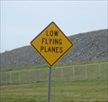 view gallery view galleryNE2.1 km |  Low Flying Plane - Binghamton, NY Low Flying Plane - Binghamton, NY
in Uncommon Crossing Signs Commercial Drive passes under the flight path at Greater Binghamton Airport. posted by: ripraff location: New York date approved: 12/11/2017 last visited: never |
 view gallery view gallery E2.6 km E2.6 km
| USGS 1337 - 1900, Binghamton, NY in U.S. Benchmarks U.S. Geological Survey Benchmark Disk located at the Abbott United Methodist Church in Binghamton, NY near the intersection of Commercial Drive and Upper Stella Ireland Road. posted by: RazorbackFan location: New York date approved: 04/28/2007 last visited: 06/11/2015 |
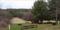
 view gallery view galleryE3.4 km |  Little Choconut site 2c/28 - Johnson City, NY Little Choconut site 2c/28 - Johnson City, NY
in Water Dams This flood control dam is near the airport posted by: ripraff location: New York date approved: 10/12/2015 last visited: never |
 view gallery view galleryS3.5 km |  Finch Hollow Nature Center - Johnson City, NY Finch Hollow Nature Center - Johnson City, NY
in Nature Centers "Located at 1394 Oakdale Road in Johnson City, Finch Hollow Nature Center is a natural history museum with approximately 1 mile of scenic, easy-to-walk nature trails" posted by: ripraff location: New York date approved: 04/26/2015 last visited: never |
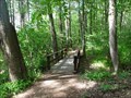 view gallery view galleryS3.7 km |  Finch Hollow Nature Center - Johnson City, New York Finch Hollow Nature Center - Johnson City, New York
in Hiking Path Footbridges This trail used to go around a pond. This bridge crosses one of the streams leading into the pond. There is another stream that used to have a crossing, but no longer does. posted by: ripraff location: New York date approved: 06/12/2019 last visited: never |
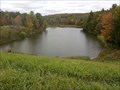
 view gallery view galleryS3.7 km | Finch Hollow Dam - Endwell, NY in Water Dams Finch Hollow Nature Center has trails that go around the pond created by a flood control dam posted by: ripraff location: New York date approved: 09/29/2015 last visited: never |
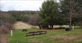
 view gallery view galleryNE3.9 km |  Feed the Farm Animals - Apple Hills Farm - Binghamton, NY Feed the Farm Animals - Apple Hills Farm - Binghamton, NY
in Feeding the Animals Apple Hills has a small area with animals near the cafe-gift shop. You can buy food at the cash register in the cafe. posted by: ripraff location: New York date approved: 08/06/2017 last visited: never |
 view gallery view galleryE3.9 km | Dimmock Hill Golf Course - Binghamton, NY in Water Dams This dam is used to store "2 million gallons of clean spring-fed water, which is enough to irrigate the golf course for 2 hours a day for 180 consecutive days and still have an abundant supply remaining" posted by: ripraff location: New York date approved: 11/02/2015 last visited: never |
 view gallery view galleryE3.9 km | Dimmick Hill Cemetery - West Chenango, NY in Worldwide Cemeteries This cemetery is on the side of Brooks Road. There are a few remnants of stones left. There are trees and mowed grass. posted by: ripraff location: New York date approved: 08/12/2016 last visited: never |
 view gallery view galleryNE3.9 km |  Apple Hills - Binghamton, NY Apple Hills - Binghamton, NY
in Pick-Your-Own Farms "Bring your family and pick fresh fruits all season long! " posted by: ripraff location: New York date approved: 07/07/2015 last visited: never |
 view gallery view gallery NW4 km NW4 km
| US Dept. Interior Geological Survey - 29 CRH - Maine, NY in U.S. Benchmarks US Department of Interior Geological Survey Disk 29 CRH (1017 FT) in Maine, NY on creek bridge on East Maine Road. posted by: RazorbackFan location: New York date approved: 06/25/2007 last visited: 07/26/2015 |
 view gallery view gallery SW4 km SW4 km
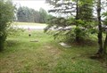
| Oak Hill Cemetery - Maine, NY in Worldwide Cemeteries This is a small mowed area without a fence or sign. posted by: ripraff location: New York date approved: 08/07/2016 last visited: never |
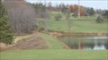
 view gallery view galleryE4 km |  Dimmock Hill Golf Course Dimmock Hill Golf Course
in Public and Private Golf Courses "The scenic 18 hole layout was carved out of a hardwood forest and encompasses 149 acres of rolling landscapes. The 5 ponds on the course add to its beauty and challenge." posted by: ripraff location: New York date approved: 11/02/2015 last visited: never |
 view gallery view galleryNW4.2 km | US Dept. Interior Geological Survey - 30 CRH - Maine, NY in U.S. Benchmarks US Department of Interior Geological Survey Disk 30 CRH (950 FT) in Maine, NY on culvert under state highway 26. posted by: RazorbackFan location: New York date approved: 06/28/2007 last visited: 01/28/2016 |
 view gallery view galleryNW5 km | Allentown Cemetery - Glen Aubrey, NY in Worldwide Cemeteries Allentown Cemetery is by the side of NY route 26 near Glen Aubrey in Broome County. The older graves are from the 1800's. posted by: ripraff location: New York date approved: 01/29/2016 last visited: never |
 view gallery view gallery W5 km W5 km
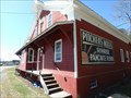
|  Pitchers Mills - Maine, NY Pitchers Mills - Maine, NY
in Water Mills This mill was used to grind grains. It existed in 1830, but ceased operation in 1955. It was restored beginning in 1993. It is now a museum run by the town of Maine, NY Historical Society. posted by: ripraff location: New York date approved: 03/30/2016 last visited: never |
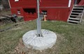 view gallery view galleryW5 km |  Pitchers Mills - Maine, NY Pitchers Mills - Maine, NY
in Millstones There are 2 millstones at Pitcher's Mills, which was running by 1830, but is now a museum. One millstone is by the building half in the ground, the other is around the flagpole. posted by: ripraff location: New York date approved: 03/30/2016 last visited: never |
|