 view gallery view gallery SE2.7 km SE2.7 km
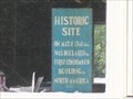
|   First Condemned Building in North America First Condemned Building in North America
in Massachusetts Historical Markers The First Condemned Building in North America - 1768 - Plymouth, MA. posted by:  CorieW CorieW location: Massachusetts date approved: 07/16/2007 last visited: never |
 view gallery view gallery NE4 km NE4 km
|  Self-Guided Historical Tours of Pembroke, Massachusetts Self-Guided Historical Tours of Pembroke, Massachusetts
in Girl Scout Gold Award Project Sites Self-guided historical walking and driving tours of Pembroke, Massachusetts, were developed as a Girl Scout Gold Award project by Charlotte Skolnick. posted by: FearsomeFoursome location: Massachusetts date approved: 05/15/2013 last visited: 09/23/2015 |
 view gallery view gallery SW5 km SW5 km
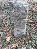
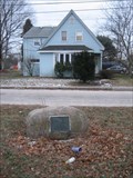
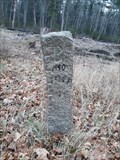
|  Hanson - Halifax line on Hudson St. Hanson - Halifax line on Hudson St.
in U.S. Historic Survey Stones and Monuments Stone post marking the Hanson-Halifax Town boundary on Hudson St. posted by: STEMARTHON location: Massachusetts date approved: 12/02/2019 last visited: never |
 view gallery view gallery W5 km W5 km
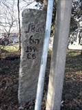
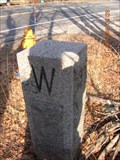
| Hanson East Bridgewater line Cedar St. in U.S. Historic Survey Stones and Monuments Stone Pillar marking the border between East Bridgewater and Hanson on Cedar St. posted by: STEMARTHON location: Massachusetts date approved: 12/02/2019 last visited: never |
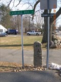
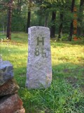 view gallery view galleryW5.8 km | Hanson East Bridgewater town line in U.S. Historic Survey Stones and Monuments Stone pillar marking the Hanson/East Bridgewater town line on Route 27. posted by: STEMARTHON location: Massachusetts date approved: 10/26/2008 last visited: never |
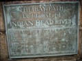 view gallery view gallery N6.4 km N6.4 km
| The Bay Path at Luddam's Ford Across the Indian Head River in Massachusetts Historical Markers Here is described the industrial activity at this location on the North River between Hanover and Pembroke. posted by: NorStar location: Massachusetts date approved: 01/09/2007 last visited: 06/28/2008 |
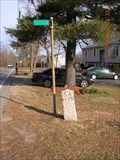
 view gallery view gallerySW7.1 km | Halifax-East Bridgewater town border in U.S. Historic Survey Stones and Monuments Stone pillar marking the Halifax- East Bridgewater town border on MA State Route 106. posted by: STEMARTHON location: Massachusetts date approved: 10/24/2014 last visited: never |
 view gallery view galleryNE7.4 km |  Pembroke Friends Meetinghouse - Pembroke MA Pembroke Friends Meetinghouse - Pembroke MA
in Wikipedia Entries The Pembroke Friends Meetinghouse was built in 1706 by Robert Barker with later 19th-century additions. It is one of the oldest Quaker meetinghouses in the United States. posted by:  nomadwillie nomadwillie location: Massachusetts date approved: 01/23/2023 last visited: never |
 view gallery view galleryNE7.4 km |  Friends Burying Ground Memorials - Pembroke MA Friends Burying Ground Memorials - Pembroke MA
in Worldwide Cemeteries The meeting house was built in 1706 by Robert Barker with later 19th-century additions. The cemetery is located in back of the meetinghouse and contains about 50 interments. posted by: nomadwillie location: Massachusetts date approved: 01/24/2023 last visited: never |
 view gallery view galleryNE7.4 km |  Pembroke Friends Meetinghouse - Pembroke MA Pembroke Friends Meetinghouse - Pembroke MA
in U.S. National Register of Historic Places The Pembroke Friends Meetinghouse was built in 1706 by Robert Barker with later 19th-century additions. It is one of the oldest Quaker meetinghouses in the United States. posted by: nomadwillie location: Massachusetts date approved: 01/24/2023 last visited: never |
 view gallery view galleryNE7.4 km |  Pembroke Friends Meetinghouse - Pembroke MA Pembroke Friends Meetinghouse - Pembroke MA
in Churchyard Cemeteries The meeting house was built in 1706 by Robert Barker with later 19th-century additions. The cemetery is located in back of the meetinghouse and contains about 50 interments. posted by: nomadwillie location: Massachusetts date approved: 01/23/2023 last visited: never |
 view gallery view galleryNE7.4 km |  Pembroke Friends Meetinghouse - Pembroke MA Pembroke Friends Meetinghouse - Pembroke MA
in Quaker Meeting Houses The Pembroke Friends Meetinghouse was built in 1706 by Robert Barker with later 19th-century additions. It is one of the oldest Quaker meetinghouses in the United States. posted by: nomadwillie location: Massachusetts date approved: 01/28/2023 last visited: never |
 view gallery view galleryW7.6 km | East Bridgewater/Whitman town line in U.S. Historic Survey Stones and Monuments Stone post marking the East Bridewater/Whitman town line. posted by: STEMARTHON location: Massachusetts date approved: 11/05/2008 last visited: never |
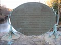 view gallery view galleryN7.7 km | Shipyards on the North River in Massachusetts Historical Markers One of the oval signs on a bridge over the North River between Hanover and Pembroke tells about the shipyards that were there. posted by: NorStar location: Massachusetts date approved: 02/28/2007 last visited: 09/23/2015 |
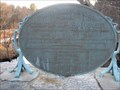 view gallery view galleryN7.7 km | Bridges Between Pembroke and Hanover in Massachusetts Historical Markers The west sign of two oval signs on this bridge tells of the bridges erected at and near this crossing. posted by: NorStar location: Massachusetts date approved: 02/28/2007 last visited: 09/23/2015 |
 N8 km | Hanover, MA in Wikipedia Entries Hanover, MA posted by: geo50chevy location: Massachusetts date approved: 05/07/2006 last visited: 09/23/2015 |
 view gallery view gallery NW8.2 km NW8.2 km
| America's First Bell Foundry in Massachusetts Historical Markers The first foundry dedicated to making bells was here in the 'Little Comfort' section of Old Abington, now called Whitman. posted by: NorStar location: Massachusetts date approved: 02/15/2007 last visited: 05/24/2008 |
 view gallery view galleryNW8.2 km | Little Comfort Historical Park in Massachusetts Historical Markers Little Comfort Historial Park - I just like the name. posted by: NorStar location: Massachusetts date approved: 02/15/2007 last visited: 02/12/2011 |
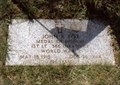 view gallery view galleryNW8.5 km |  John R. Fox-Whitman, MA John R. Fox-Whitman, MA
in Medal Of Honor Resting Places World War II Medal of Honor Recipient for action at Sommocolonia, Italy on December 26, 1944. He was killed in action. He is buried in Colebrook Cemetery, Whitman, MA. posted by: Don.Morfe location: Massachusetts date approved: 11/04/2017 last visited: 12/19/2021 |
 view gallery view galleryN8.9 km |  DQ Grill & Chill - 579 Washington Street - Hanover, Massachusetts USA DQ Grill & Chill - 579 Washington Street - Hanover, Massachusetts USA
in Dairy Queen Restaurants Dairy Queen's DQ Grill & Chill on Washington Street in Hanover, MA is a sit down and drive-thru restaurant that specializes in ice cream desserts and also offers burgers and fries menu items. posted by: 401Photos location: Massachusetts date approved: 01/11/2019 last visited: never |
 view gallery view gallerySW9 km | Bridgewater-East Bridgewater Boundary West Pond St. in U.S. Historic Survey Stones and Monuments Two Stone posts marking the Bridgewater-East Bridgewater town boundary on West Pond Street. posted by: STEMARTHON location: Massachusetts date approved: 12/02/2019 last visited: never |
 view gallery view galleryNW9.2 km | Abington /Whitman Town Border in U.S. Historic Survey Stones and Monuments Stone post marking the border of the towns of Abington and Whitman. posted by: STEMARTHON location: Massachusetts date approved: 02/16/2008 last visited: never |
 view gallery view galleryNW9.7 km | Abington/Rockland Town Border in U.S. Historic Survey Stones and Monuments Stone post marking the border of the present day towns of Abington and Rockland. posted by: STEMARTHON location: Massachusetts date approved: 02/16/2008 last visited: never |
 view gallery view gallery E10 km E10 km
|  Dunkin Donuts - Rt 3 Exit 5 - Plymouth, MA Dunkin Donuts - Rt 3 Exit 5 - Plymouth, MA
in Dunkin Donuts' This Dunkin Donuts is co-located with a Gulf Express gas station and store at Exit 5 from Route 3 in Plymouth, Massachusetts. There is drive-thru service as well as an inside counter. No seating. posted by: silverquill location: Massachusetts date approved: 09/10/2009 last visited: never |
 view gallery view galleryNW10.1 km | Abington Town Border in U.S. Historic Survey Stones and Monuments This is a stone pillar marking the border between the towns of Abington and Whitman. posted by: STEMARTHON location: Massachusetts date approved: 02/16/2008 last visited: never |
|