 view gallery view gallery NW16.3 km NW16.3 km
|   City of Rocks National Reserve - Almo, ID City of Rocks National Reserve - Almo, ID
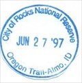
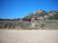
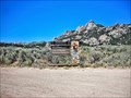
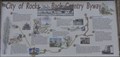
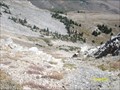
in NPS Passport Cancellation Stations Emigrants of the California Trail describe the rocks here in vivid detail as "a city of tall spires,” “steeple rocks," and "the silent city." Today, this backcountry byway attracts rock climbers, campers, hikers, hunters, and those with the spirit of adventure. posted by:  Don.Morfe Don.Morfe location: Idaho date approved: 02/14/2020 last visited: 12/23/2022 |
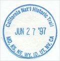 view gallery view galleryNW16.3 km | California National Historic Trail-MO,KS,NE,WY,ID,UT,NV,CA - Almo, ID in NPS Passport Cancellation Stations Follow in the footsteps of over 250,000 emigrants who traveled to the gold fields and rich farmlands of California during the 1840s and 1850s: the greatest mass migration in American history. The California National Historic Trail is over 5,000 miles long and covers portions of 10 states. posted by: Don.Morfe location: Idaho date approved: 02/25/2020 last visited: 12/23/2022 |
 view gallery view galleryNW16.4 km |  City of Rocks National Reserve - Almo ID City of Rocks National Reserve - Almo ID
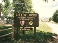
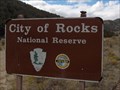
in Wikipedia Entries The City of Rocks National Reserve, also known as the Silent City of Rocks, is a United States National Reserve and state park in south-central Idaho. It is widely known for its enormous granite rock formations and excellent rock climbing. posted by: Don.Morfe location: Idaho date approved: 04/29/2022 last visited: 12/23/2022 |
 view gallery view galleryNW16.4 km |  City of Rocks National Reserve - Almo ID City of Rocks National Reserve - Almo ID
in Official Local Tourism Attractions The City of Rocks National Reserve, also known as the Silent City of Rocks, is a United States National Reserve and state park in south-central Idaho. It is widely known for its enormous granite rock formations and excellent rock climbing. posted by: Don.Morfe location: Idaho date approved: 04/29/2022 last visited: 12/23/2022 |
 view gallery view galleryNW16.9 km |  Almo, ID 83312 Almo, ID 83312
in U.S. Post Offices Post Office located in Almo, ID posted by: greywolf1242 location: Idaho date approved: 12/07/2006 last visited: never |
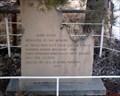 view gallery view galleryNW16.9 km |  Dedicated to the memory of,, Dedicated to the memory of,,
in Idaho Historical Markers Old monument recently uncovered. posted by:  muddawber muddawber location: Idaho date approved: 10/17/2006 last visited: 10/18/2006 |
 view gallery view galleryNW16.9 km |  Idaho State Highway R/W # 41 Idaho State Highway R/W # 41
in U.S. Benchmarks This is an Idaho State Highway Right of Way Marker. posted by: greywolf1242 location: Idaho date approved: 12/07/2006 last visited: never |
 view gallery view galleryNW16.9 km |  City of Rocks City of Rocks
in Roadside Attractions California Trail wagon trains of the 1840s and 1850s left the Raft River valley and traveled through the area and over Granite Pass into Nevada. posted by: nomadwillie location: Idaho date approved: 09/26/2011 last visited: 12/23/2022 |
 view gallery view galleryNW16.9 km |  City of Rocks - Almo ID City of Rocks - Almo ID
in U.S. National Register of Historic Places California Trail wagon trains of the 1840s and 1850s left the Raft River valley and traveled through the area and over Granite Pass into Nevada. posted by: nomadwillie location: Idaho date approved: 09/15/2011 last visited: 12/23/2022 |
 view gallery view galleryNW16.9 km | ") City of Rocks National Reserve - Idaho City of Rocks National Reserve - Idaho
in National Parks (U.S.) City of Rocks National Reserve - Almo, Idaho posted by: Chooch72 location: Idaho date approved: 10/08/2007 last visited: 12/23/2022 |
 view gallery view galleryNW17.2 km |  City of Rocks National Reserve City of Rocks National Reserve
in National Parks of the World City of Rocks National Reserve - Almo, Idaho, USA posted by: Chooch72 location: Idaho date approved: 10/07/2007 last visited: 12/23/2022 |
 view gallery view galleryNW17.4 km |  City of Rocks National Reserve - Almo ID City of Rocks National Reserve - Almo ID
in Wagon Roads and Trails The wagon trains of the 1840 and 1850's traveled thru the area known today as the City of Rocks on the California Trail posted by: nomadwillie location: Idaho date approved: 03/01/2013 last visited: 12/23/2022 |
 view gallery view galleryNW20.8 km |  Castle Rocks State Park - Idaho Castle Rocks State Park - Idaho
in State/Provincial Parks Castle Rock State Park posted by: kJfishman location: Idaho date approved: 01/29/2008 last visited: 10/25/2022 |
 view gallery view gallery SE31.5 km SE31.5 km
|  Old russian cemetery Old russian cemetery
in Abandoned Cemeteries Old russian cemetery posted by: saltrunner75 location: Utah date approved: 05/25/2012 last visited: 11/04/2016 |
 view gallery view gallery N35.7 km N35.7 km
|  City of Rocks Back Country Byway ~ Connor Creek City of Rocks Back Country Byway ~ Connor Creek
in National Scenic Byways Connor Creek is the point where the Byway splits from Idaho Highway 77 and heads west toward the City of Rocks National Preserve. posted by: brwhiz location: Idaho date approved: 12/08/2013 last visited: never |
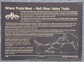 view gallery view galleryN37.3 km |  Where Trails Meet - Raft River Valley Trails ~ 513 Where Trails Meet - Raft River Valley Trails ~ 513
in D.U.P. Historic Markers This monument, erected by the Daughters of Utah Pioneers, stands just east of Idaho Highway 77 on Cassia Creek Road/Gamble Lane/1700 South Road. posted by: brwhiz location: Idaho date approved: 12/11/2013 last visited: 03/23/2020 |
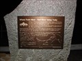 view gallery view galleryN37.3 km | Where Trails Meet - Raft River Valley Trails in Idaho Historical Markers The Raft River Valley was used by Native Americans as a place to hunt and winter because the snow didn't lie in the valley and there was good water and plenty of grass for the animals..... posted by: JacobBarlow location: Idaho date approved: 11/21/2007 last visited: 03/23/2020 |
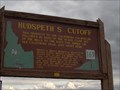 view gallery view galleryN38.1 km | Hudspeth's Cutoff - #169 in Idaho Historical Markers Hudspeth's Cutoff - Idaho Historical Marker # 169 - Malta, ID posted by: Chooch72 location: Idaho date approved: 09/29/2007 last visited: 03/23/2020 |
 view gallery view galleryN39.9 km |  Mt. Harrison- 9265 feet Mt. Harrison- 9265 feet
in Elevation Signs This sign is located on the top of Mt. Harrison. It has fantastic panoramic views from this location perfect for fire spotting! posted by: muddawber location: Idaho date approved: 09/15/2008 last visited: 07/26/2020 |
 view gallery view galleryN39.9 km |  Mt. Harrison B-24 crash site Mt. Harrison B-24 crash site
in Plane Crash Sites Fog was the ultimate demise of this training flight. posted by: muddawber location: Idaho date approved: 09/15/2008 last visited: 10/25/2022 |
 view gallery view galleryN40.2 km | Land Survey Marker T 18 SR 25 E in U.S. Benchmarks A quick and easy benchmark to find along state highway 77. posted by: muddawber location: Idaho date approved: 02/13/2007 last visited: never |
 view gallery view galleryN41 km | Malta, Idaho - 83342 in U.S. Post Offices Malta, Idaho Post Office - Zip 83342 posted by: Chooch72 location: Idaho date approved: 09/30/2007 last visited: 08/11/2011 |
 view gallery view galleryNW42.2 km |  Oakley Valley Historical Museum Oakley Valley Historical Museum
in History Museums This History Museum is located on Main Street in the center of Oakley. posted by: brwhiz location: Idaho date approved: 11/30/2013 last visited: never |
 view gallery view galleryNW42.2 km | Oakley, Idaho 83346 in U.S. Post Offices This Post Office is located at 130 W Main Street in Oakley, Idaho. posted by: brwhiz location: Idaho date approved: 11/11/2013 last visited: never |
 view gallery view galleryNW42.2 km | Oakley Valley Historical Museum in Official Local Tourism Attractions This Official Local Tourism Attraction is located on Main Street in the center of Oakley. posted by: brwhiz location: Idaho date approved: 11/30/2013 last visited: never |
|