 view gallery view gallery NE35.9 km NE35.9 km
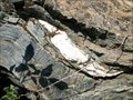
|   Serpentinite of The Rattlesnake Terrain Serpentinite of The Rattlesnake Terrain
in Places of Geologic Significance The Rattlesnake Terrain is a mash of gabbro, chert, granite, and sandstone within serpentite that was added to the North American Plate in the Late Jurrasic during an accretionary episode. posted by:  TerryDad2 TerryDad2 location: California date approved: 01/03/2010 last visited: 07/09/2010 |
 view gallery view gallery SE40.9 km SE40.9 km
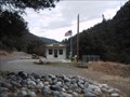
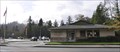
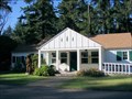
|  Forks of Salmon, CA 96031 Forks of Salmon, CA 96031
in U.S. Post Offices This could be the most remote post office in California. posted by:  michael3900 michael3900 location: California date approved: 09/15/2008 last visited: never |
 view gallery view gallery W44.1 km W44.1 km
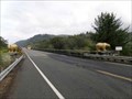
|  South end of Klamath River Bridge Golden Bears - California South end of Klamath River Bridge Golden Bears - California
in Bear Statues Golden Bears at south end of Klamath River Bridge. posted by: Volcanoguy location: California date approved: 02/20/2014 last visited: 09/24/2013 |
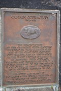 view gallery view galleryW44.3 km |  Captain Courageous Captain Courageous
in E Clampus Vitus Historical Markers In 1964 it SUCKED to live here. But the folks drew determination from the survival of this tough old Steer. Unsinkable Captain Courageous. posted by: Tygress location: California date approved: 05/19/2011 last visited: 04/13/2016 |
 view gallery view galleryW44.6 km | Klamath, California 95548 in U.S. Post Offices This Post Office is located at 141 Klamath Blvd in Klamath, California. posted by: brwhiz location: California date approved: 12/25/2011 last visited: never |
 view gallery view galleryW45.1 km | Old Douglas Memorial Bridge Bears - California in Bear Statues Bears on old Douglas Memorial Bridge approach. posted by: Volcanoguy location: California date approved: 02/20/2014 last visited: 08/05/2020 |
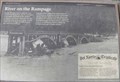 view gallery view galleryW45.1 km |  River on the Rampage - California River on the Rampage - California
in Signs of History History sign at old Douglas Memorial Bridge site in Redwoods National Park. posted by: Volcanoguy location: California date approved: 02/16/2014 last visited: 09/23/2013 |
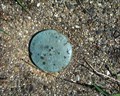 view gallery view galleryW45.1 km |  Elevation Elevation
in U.S. Benchmarks Del Norte County Dept. of Public Works elevation disk. posted by: scottaponte location: California date approved: 03/17/2008 last visited: never |
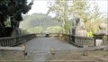
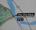 view gallery view galleryW45.2 km |  Old Douglas Memorial Bridge - Redwoods N.P. - California Old Douglas Memorial Bridge - Redwoods N.P. - California
in 'You Are Here' Maps You Are Here map at old Douglas Memorial Bridge in Redwoods National Park. posted by: Volcanoguy location: California date approved: 02/15/2014 last visited: 09/23/2013 |
 view gallery view gallery NW45.7 km NW45.7 km
|  Collier Tunnel Safety Rest Area - U.S. Hwy. 199 Collier Tunnel Safety Rest Area - U.S. Hwy. 199
in Highway Rest Areas U.S. Hwy. 199 rest area between Crescent City, CA and Cave Junction, OR. posted by: Volcanoguy location: California date approved: 01/08/2013 last visited: 09/25/2012 |
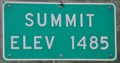 view gallery view gallery SW46.3 km SW46.3 km
|  US Highway 101 Summit ~ Elevation 1485 Feet US Highway 101 Summit ~ Elevation 1485 Feet
in Elevation Signs This Elevation Sign is on the west side of US Highway 101 on the eastern edge of Prairie Creek Redwoods State Park between Crescent City and Trinidad, California. posted by: brwhiz location: California date approved: 12/12/2012 last visited: 09/25/2012 |
 view gallery view galleryNW46.5 km | Gasquet, California ~ Elevation 370 Feet in Elevation Signs This combination Population/Elevation Sign is on the north side of US Highway 199 as you enter Gasquet from the east. posted by: brwhiz location: California date approved: 12/13/2012 last visited: never |
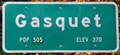 view gallery view galleryNW46.5 km |  Gasquet, California ~ Population 350 Gasquet, California ~ Population 350
in Population Signs This combination Population/Elevation Sign is on the north side of US Highway 199 as you enter Gasquet from the east. posted by: brwhiz location: California date approved: 12/13/2012 last visited: never |
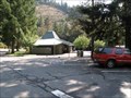
 view gallery view galleryNW46.7 km |  Smokey at Smith River National Recreation Area Headquarters - Gasquet, CA Smokey at Smith River National Recreation Area Headquarters - Gasquet, CA
in Smokey Bear Sign Sightings This hand-carved Smokey stands beside the Smith River National Recreation Area Headquarters in Gasquet, California, on Route 199, The Redwood Highway. posted by: silverquill location: California date approved: 02/18/2009 last visited: 09/23/2012 |
 view gallery view galleryNW46.7 km |  Smith River National Recreation Area Headquarters - Gasquet, CA Smith River National Recreation Area Headquarters - Gasquet, CA
in Ranger Stations The 300-acre Smith River National Recreation area was formed in 1990 and lies in extreme northern California along the Oregon border. There are five camp grounds, 65 miles of trails, and trophy clsss fishing on the Smith River. posted by: silverquill location: California date approved: 02/18/2009 last visited: never |
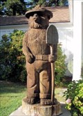 view gallery view galleryNW46.7 km |  Smokey at Smith River National Recreation Area Headquarters - Gasquet, CA Smokey at Smith River National Recreation Area Headquarters - Gasquet, CA
in Outside Wooden Display Carvings This hand-carved Smokey stands beside the Smith River National Recreation Area Headquarters in Gasquet, California, on Route 199, The Redwood Highway. posted by: silverquill location: California date approved: 02/19/2009 last visited: 09/23/2012 |
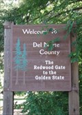 view gallery view gallery N46.7 km N46.7 km
|  The Redwood Gate to the Golden State - Del Norte County, CA The Redwood Gate to the Golden State - Del Norte County, CA
in Welcome Signs This sign is seen entering Del Norte County from the northeast on Highway 199, the Redwood Highway, that connects Grants Pass, Oregon, to the Crescent City, California, on the Pacific Coast. posted by: silverquill location: California date approved: 02/18/2009 last visited: 08/29/2013 |
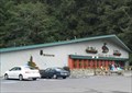
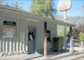 view gallery view galleryNW47 km | Gasquet, CA 95543 in U.S. Post Offices This is the post office for the roadside town of Gasquet, California. It shares a building with a store and the fire department on Route 199 between the Oregon Caves National Monument and the Route 101 on the coast. posted by: silverquill location: California date approved: 10/27/2008 last visited: 11/17/2011 |
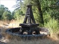 view gallery view galleryNW47 km |  Stone Eiffel Tower - Gasquet, CA Stone Eiffel Tower - Gasquet, CA
in Realistic Object Sculptures This is a random roadside sculpture along the scenic Redwood Highway (Rt. 199) near the post office in tiny Gasquet, California. There may have been a business, home or other building here at one time, or it may be a random placement. posted by: silverquill location: California date approved: 02/18/2009 last visited: 07/01/2010 |
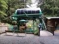 view gallery view galleryW47.5 km |  SkyTrail - Trees of Mystery - Klamath, California SkyTrail - Trees of Mystery - Klamath, California
in Aerial Lifts The SkyTrail Gondola Lift at the Trees of Mystery near Klamath, California. posted by: Volcanoguy location: California date approved: 02/18/2014 last visited: 09/24/2013 |
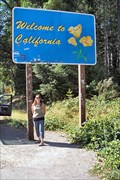 view gallery view galleryN47.5 km |  Welcome To California Ca/Or Border on US199 Welcome To California Ca/Or Border on US199
in Border Crossings The California welcome sign about .1 mile south of the OR/CA border on US highway 199 Between Grants Pass, Oregon and Crescent City, California. posted by: HeyRob4449 location: California date approved: 10/20/2007 last visited: 09/23/2012 |
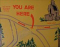 view gallery view galleryW47.6 km | Trees of Mystery Trails - Klamath, California in 'You Are Here' Maps You Are Here map at Trees of Mystery. posted by: Volcanoguy location: California date approved: 02/16/2014 last visited: 09/24/2013 |
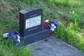 view gallery view galleryW47.6 km |  Williams Cemetery - Klamath, CA Williams Cemetery - Klamath, CA
in Worldwide Cemeteries The Williams Cemetery is located on Klamath Beach Road overlooking the mouth of the Klamath River. posted by: hummerstation location: California date approved: 09/06/2018 last visited: 08/26/2021 |
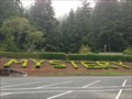 view gallery view galleryW47.8 km |  Trees of Mystery - Klamath, CA Trees of Mystery - Klamath, CA
in Readable From Above A large planting to bushes next to the parking lot for the "Trees of Mystery" is readable from a satellite view. posted by: DougK location: California date approved: 09/08/2013 last visited: 07/14/2014 |
 view gallery view galleryW47.8 km |  End of the Trail Museum - Trees of Mystery - Klamath, California End of the Trail Museum - Trees of Mystery - Klamath, California
in History Museums End of the Trail Museum at the Trees of Mystery. posted by: Volcanoguy location: California date approved: 02/17/2014 last visited: 06/11/2014 |
|