 view gallery view gallery SE35.7 km SE35.7 km
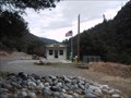
|   Forks of Salmon, CA 96031 Forks of Salmon, CA 96031
in U.S. Post Offices This could be the most remote post office in California. posted by:  michael3900 michael3900 location: California date approved: 09/15/2008 last visited: never |
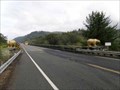 view gallery view gallery W41.8 km W41.8 km
|  South end of Klamath River Bridge Golden Bears - California South end of Klamath River Bridge Golden Bears - California
in Bear Statues Golden Bears at south end of Klamath River Bridge. posted by:  Volcanoguy Volcanoguy location: California date approved: 02/20/2014 last visited: 09/24/2013 |
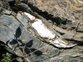 view gallery view gallery NE42 km NE42 km
|  Serpentinite of The Rattlesnake Terrain Serpentinite of The Rattlesnake Terrain
in Places of Geologic Significance The Rattlesnake Terrain is a mash of gabbro, chert, granite, and sandstone within serpentite that was added to the North American Plate in the Late Jurrasic during an accretionary episode. posted by: TerryDad2 location: California date approved: 01/03/2010 last visited: 07/09/2010 |
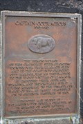 view gallery view galleryW42.3 km |  Captain Courageous Captain Courageous
in E Clampus Vitus Historical Markers In 1964 it SUCKED to live here. But the folks drew determination from the survival of this tough old Steer. Unsinkable Captain Courageous. posted by: Tygress location: California date approved: 05/19/2011 last visited: 04/13/2016 |
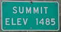 view gallery view gallery SW42.3 km SW42.3 km
|  US Highway 101 Summit ~ Elevation 1485 Feet US Highway 101 Summit ~ Elevation 1485 Feet
in Elevation Signs This Elevation Sign is on the west side of US Highway 101 on the eastern edge of Prairie Creek Redwoods State Park between Crescent City and Trinidad, California. posted by: brwhiz location: California date approved: 12/12/2012 last visited: 09/25/2012 |
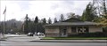 view gallery view galleryW42.8 km | Klamath, California 95548 in U.S. Post Offices This Post Office is located at 141 Klamath Blvd in Klamath, California. posted by: brwhiz location: California date approved: 12/25/2011 last visited: never |
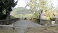 view gallery view galleryW43.1 km | Old Douglas Memorial Bridge Bears - California in Bear Statues Bears on old Douglas Memorial Bridge approach. posted by: Volcanoguy location: California date approved: 02/20/2014 last visited: 08/05/2020 |
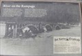 view gallery view galleryW43.1 km |  River on the Rampage - California River on the Rampage - California
in Signs of History History sign at old Douglas Memorial Bridge site in Redwoods National Park. posted by: Volcanoguy location: California date approved: 02/16/2014 last visited: 09/23/2013 |
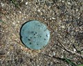 view gallery view galleryW43.1 km |  Elevation Elevation
in U.S. Benchmarks Del Norte County Dept. of Public Works elevation disk. posted by: scottaponte location: California date approved: 03/17/2008 last visited: never |
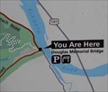 view gallery view galleryW43.1 km |  Old Douglas Memorial Bridge - Redwoods N.P. - California Old Douglas Memorial Bridge - Redwoods N.P. - California
in 'You Are Here' Maps You Are Here map at old Douglas Memorial Bridge in Redwoods National Park. posted by: Volcanoguy location: California date approved: 02/15/2014 last visited: 09/23/2013 |
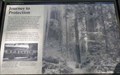 view gallery view gallerySW44.6 km | Journey to Protection - California in Signs of History History sign near the Big Tree Trailhead in Prairie Creek Redwoods State Park. posted by: Volcanoguy location: California date approved: 02/15/2014 last visited: 09/23/2013 |
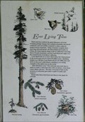 view gallery view gallerySW44.6 km |  Ever Living Trees - California Ever Living Trees - California
in Flora and Fauna Information Signs One of a pair of Flora and Fauna sign at Big Tree Trailhead. posted by: Volcanoguy location: California date approved: 02/14/2014 last visited: 09/23/2013 |
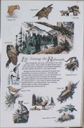 view gallery view gallerySW44.6 km | Life Among the Redwoods - California in Flora and Fauna Information Signs One of a pair of Flora and Fauna sign at Big Tree Trailhead. posted by: Volcanoguy location: California date approved: 02/14/2014 last visited: 09/23/2013 |
 view gallery view gallerySW45.5 km |  Redwood National Park - Crescent City CA Redwood National Park - Crescent City CA
in Satellite Imagery Oddities The Redwood National and State Parks (RNSP) are a complex of one national park and three state parks, cooperatively managed, located in the United States along the coast of northern California. posted by: Don.Morfe location: California date approved: 03/10/2022 last visited: 07/22/2000 |
 view gallery view gallerySW45.5 km |  Redwood National and State Parks - Crescent City CA Redwood National and State Parks - Crescent City CA
in Wikipedia Entries The Redwood National and State Parks (RNSP) are a complex of one national park and three state parks, cooperatively managed, located in the United States along the coast of northern California. posted by: Don.Morfe location: California date approved: 03/10/2022 last visited: 07/22/2000 |
 view gallery view gallerySW45.5 km |  Redwood National Park - Crescent City CA Redwood National Park - Crescent City CA
in Official Local Tourism Attractions The Redwood National and State Parks (RNSP) are a complex of one national park and three state parks, cooperatively managed, located in the United States along the coast of northern California. posted by: Don.Morfe location: California date approved: 03/11/2022 last visited: 07/22/2000 |
 view gallery view gallerySW45.5 km |  Redwood National and State Parks - Crescent City CA Redwood National and State Parks - Crescent City CA
in National Parks of the World The Redwood National and State Parks (RNSP) are a complex of one national park and three state parks, cooperatively managed, located in the United States along the coast of northern California. posted by: Don.Morfe location: California date approved: 03/11/2022 last visited: 07/22/2000 |
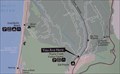 view gallery view gallerySW45.7 km | Visitor Center Trailhead - Prairie Creek Redwoods S.P. - California in 'You Are Here' Maps You Are Here map at Visitor Center Trailhead in Prairie Creek Redwoods State Park. posted by: Volcanoguy location: California date approved: 02/14/2014 last visited: 09/23/2013 |
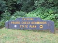
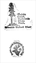 view gallery view gallerySW45.7 km |  Prairie Creek Redwoods SP - California Prairie Creek Redwoods SP - California
in State Park Passport Locations Prairie Creek is a sanctuary of old growth coast redwood. This passport stamp features an image of a tall redwood tree. A second stamp features the head of an Elk, also found in this park. posted by: DougK location: California date approved: 07/14/2013 last visited: 10/20/2015 |
 view gallery view gallerySW45.7 km |  Prairie Creek Redwoods SP - California Prairie Creek Redwoods SP - California
in State/Provincial Parks Set aside in the early 1920’s by the forethought of the people of California and the generosity of the Save-the-Redwoods League, Prairie Creek is a sanctuary of old growth coast redwood. posted by: DougK location: California date approved: 07/17/2013 last visited: 10/21/1967 |
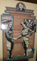 view gallery view gallerySW45.7 km | The Three C’s Rated Straight A’s - California in Signs of History History sign at Prairie Creek Redwoods State Park Visitor Center. posted by: Volcanoguy location: California date approved: 02/15/2014 last visited: 09/23/2013 |
 view gallery view gallerySW45.7 km |  Visitor Center - Prairie Creek Redwoods S.P. - California Visitor Center - Prairie Creek Redwoods S.P. - California
in Ranger Stations Visitor Center for Prairie Creek Redwoods State Park. posted by: Volcanoguy location: California date approved: 02/14/2014 last visited: 07/22/2000 |
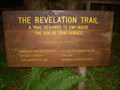 view gallery view gallerySW45.9 km |  Revelation Nature Trail Revelation Nature Trail
in Self Guided Walks and Trails The Revelation Nature trail is located near the Visitors Center of Prairie Creek Redwood State Park. The trail is approximately 1/2 mile and takes about an hour to take in the 15 interpretive plaques. posted by: Touchstone location: California date approved: 05/09/2009 last visited: 09/23/2012 |
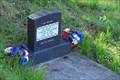 view gallery view galleryW45.9 km |  Williams Cemetery - Klamath, CA Williams Cemetery - Klamath, CA
in Worldwide Cemeteries The Williams Cemetery is located on Klamath Beach Road overlooking the mouth of the Klamath River. posted by: hummerstation location: California date approved: 09/06/2018 last visited: 08/26/2021 |
 view gallery view galleryW45.9 km |  Radar Station B-71 - California Radar Station B-71 - California
in U.S. National Register of Historic Places The historic WWII Radar Station B-71 near the mouth of the Klamath River in California. posted by: Volcanoguy location: California date approved: 02/17/2014 last visited: 08/26/2021 |
|