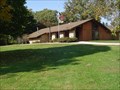
 view gallery view gallery S9.5 km S9.5 km
|   Hennepin Canal State Trail - Illinois Hennepin Canal State Trail - Illinois
in State/Provincial Parks This the main complex of the park.
The coordinates are for the entrance to the park. posted by:  S10 S10 location: Illinois date approved: 11/06/2008 last visited: never |
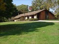 view gallery view galleryS9.5 km |  Hennipen Canal State Park. Hennipen Canal State Park.
in Wikipedia Entries The Hennepin Canal Parkway State Park, also just called the Hennepin Canal, is an abandoned waterway in northwest Illinois, between the Mississippi River at Rock Island and the Illinois River near Hennepin. posted by: S10 location: Illinois date approved: 11/22/2008 last visited: never |
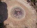
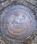
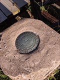 view gallery view galleryS10 km |  USC&GS N 45 - Langley, IL USC&GS N 45 - Langley, IL
in U.S. Benchmarks N45-1934 Survey Marker posted by: QCCacher7173 location: Illinois date approved: 09/19/2019 last visited: never |
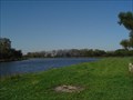 view gallery view gallery SW10.8 km SW10.8 km
|  CONFLUNCE-Hennipen Canal West, Hennipen Canal East, Hennipen Canal Feeder. CONFLUNCE-Hennipen Canal West, Hennipen Canal East, Hennipen Canal Feeder.
in River Origins, Destinations and Confluences The feeder canal starts at Rock river in Dixon Illinois and goes South and joines the main canal that goes West and East. posted by: S10 location: Illinois date approved: 10/07/2008 last visited: never |
 view gallery view gallery SE10.9 km SE10.9 km
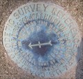
| MF1092 - USCGS SAPP 2 - IL in U.S. Benchmarks USCGS Benchmark SAPP 2 At Interstate 80 Rest area - Illinois posted by:  8Nuts MotherGoose 8Nuts MotherGoose location: Illinois date approved: 04/24/2008 last visited: 05/09/2009 |
 view gallery view gallerySE10.9 km | SAPP 2 RM 1 in U.S. Benchmarks At the I-80 East-bound Rest Area near Mile 51. posted by: 8Nuts MotherGoose location: Illinois date approved: 07/16/2010 last visited: never |
 view gallery view gallerySE10.9 km | SAPP 2 RM 2 in U.S. Benchmarks At the I-80 East-bound Rest Area near Mile 51. posted by: 8Nuts MotherGoose location: Illinois date approved: 07/16/2010 last visited: never |
 view gallery view gallerySE10.9 km |  Eastbound Interstate 80 Mile Post 51 - Princeton, IL Eastbound Interstate 80 Mile Post 51 - Princeton, IL
in Highway Rest Areas A basic rest area near Princeton, IL posted by: cldisme location: Illinois date approved: 08/30/2008 last visited: 02/01/2021 |
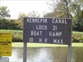 view gallery view gallerySE11.1 km |  Hennipen Canal State Trail Boat Ramp. Hennipen Canal State Trail Boat Ramp.
in Boat Ramps Boat access to the Hennipen Canal. posted by: S10 location: Illinois date approved: 10/12/2008 last visited: never |
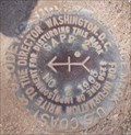
 view gallery view gallerySE11.3 km | SAPP 2 NO. 2 Azimuth Mark in U.S. Benchmarks At the West-bound Rest Area near Mile 51. posted by: 8Nuts MotherGoose location: Illinois date approved: 07/16/2010 last visited: never |
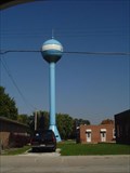 view gallery view gallerySE12.2 km |  Wyanet Water Tower. Wyanet Water Tower.
in Water Towers The tower serves about 1,028 people. posted by: S10 location: Illinois date approved: 10/12/2008 last visited: 09/07/2009 |
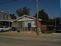 view gallery view gallerySE12.4 km |  Wyanet, Illinois 61379 Wyanet, Illinois 61379
in U.S. Post Offices This Post Office serves 1,028 people. posted by: S10 location: Illinois date approved: 10/12/2008 last visited: never |
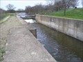 view gallery view gallerySE13.4 km |  Lock #19, Hennepin Canal, near Wyanet, IL Lock #19, Hennepin Canal, near Wyanet, IL
in Waterway Locks, Planes and Lifts Lock #19 on the Hennepin Canal, which is now a state park. posted by: KG1960 location: Illinois date approved: 04/27/2007 last visited: 05/09/2009 |
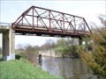 view gallery view gallerySE13.4 km |  Truss Bridge, County Road 8, Wyanet, IL Truss Bridge, County Road 8, Wyanet, IL
in Truss Bridges A truss bridge that carries County Road 8 over the Hennepin Canal and the Iowa Interstate Railroad tracks just south of Wyanet, IL. posted by: KG1960 location: Illinois date approved: 04/27/2007 last visited: 05/09/2009 |
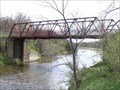 view gallery view gallerySE13.4 km | Biking/Hiking Trail Bridge, Hennepin Canal State Park, IL in Truss Bridges A bridge for the biking/hiking trail along the Hennepin Canal near Lock No. 19 just south of Wyanet, IL, just off of County Road 8. posted by: KG1960 location: Illinois date approved: 04/27/2007 last visited: 05/09/2009 |
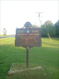 view gallery view gallery NE13.5 km NE13.5 km
|  RT.92 (North St.) , Walnut, IL RT.92 (North St.) , Walnut, IL
in Blue Star Memorial Highway Markers A blue star highway marker in walnut IL posted by: Spyderbat location: Illinois date approved: 09/11/2009 last visited: 09/07/2009 |
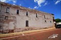
 view gallery view galleryS14.5 km |  Ghost Sign - Victor - Buda, IL Ghost Sign - Victor - Buda, IL
in Ghost Signs Victor Phonograph, His Masters Voice posted by: QCCacher7173 location: Illinois date approved: 06/19/2017 last visited: never |
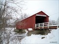 view gallery view gallery E16.6 km E16.6 km
|  Red Covered Bridge - Princeton, IL Red Covered Bridge - Princeton, IL
in U.S. National Register of Historic Places The Red Covered Bridge has spanned Bureau Creek since 1863. posted by: cldisme location: Illinois date approved: 02/12/2011 last visited: 10/22/2011 |
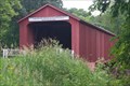 view gallery view galleryE16.6 km |  Princeton Red Covered Bridge Princeton Red Covered Bridge
in Covered Bridges The Princeton Red Covered Bridge crosses over the Big Bureau Creek. posted by: cachmandan location: Illinois date approved: 06/11/2009 last visited: 10/22/2011 |
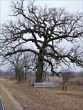 view gallery view gallerySW18.3 km |  Witness Tree - Bureau County, IL Witness Tree - Bureau County, IL
in Historic Trees A Burr Oak stands watch over the years. posted by: cldisme location: Illinois date approved: 02/07/2012 last visited: never |
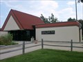
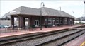 view gallery view gallerySE18.7 km |  Princeton, IL, Amtrak Station Princeton, IL, Amtrak Station
in Train Stations/Depots The train station in Princeton, IL, that is still used by Amtrak, originally of the Chicago, Burlington, and Quincy RR. posted by: KG1960 location: Illinois date approved: 04/27/2007 last visited: 10/11/2008 |
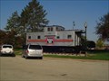 view gallery view gallerySE18.7 km |  Burlington Route 13593 - Princeton Il. Burlington Route 13593 - Princeton Il.
in Train Cabooses This cabooses is on display near the Amtrak depot. posted by: S10 location: Illinois date approved: 10/13/2008 last visited: 10/22/2010 |
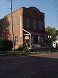 view gallery view gallerySE18.7 km |  Hatties Antiques - Princeton Il. Hatties Antiques - Princeton Il.
in Antique Shops 3 levels of antiques, main level, basment and a 1/2 levelin a side building. posted by: S10 location: Illinois date approved: 10/12/2008 last visited: never |
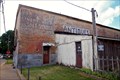 view gallery view gallerySE18.7 km | Livery Feed and Sale Stable in Ghost Signs Livery Feed and Sale Stable, Princeton, IL posted by: QCCacher7173 location: Illinois date approved: 06/19/2017 last visited: never |
 view gallery view gallerySE18.8 km | Bull Durham Ghost Sign in Ghost Signs Bull Durham posted by: QCCacher7173 location: Illinois date approved: 06/19/2017 last visited: never |
|