 view gallery view gallery SE11.7 km SE11.7 km
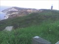
|   Gay Head Cliffs of Clay, Aquinnah, Martha's Vinyard Mass Gay Head Cliffs of Clay, Aquinnah, Martha's Vinyard Mass
in U.S. National Natural Landmarks The Gay Head Cliffs of Clay are the most beautiful sights of Martha's Vinyard. posted by:  GT.US GT.US location: Massachusetts date approved: 06/04/2007 last visited: 09/06/2022 |
 view gallery view gallery NW11.7 km NW11.7 km
|  Allens Pond Massachusetts Audubon Wildlife Sanctuary - Dartmouth, MA Allens Pond Massachusetts Audubon Wildlife Sanctuary - Dartmouth, MA
in Public Access Lands Allen Pond Massachusetts Audubon Sanctuary is a 611 acre property run by Massachusetts Audubon that has 7 miles of trails through fields, and beach. posted by:  NorStar NorStar location: Massachusetts date approved: 09/27/2015 last visited: never |
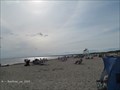
 view gallery view gallerySE11.9 km |  Aquinnah, Gay Head Clay Cliffs, Martha's Vinyard Mass Aquinnah, Gay Head Clay Cliffs, Martha's Vinyard Mass
in Penny Smashers I found this penny smasher while visiting the Gay Head Clay Cliffs of Martha's Vinyard. posted by: GT.US location: Massachusetts date approved: 06/01/2007 last visited: never |
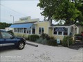 view gallery view galleryNW11.9 km |  The Bayside Restaurant - Westport, MA The Bayside Restaurant - Westport, MA
in Independent Fish Houses The Bayside Restaurant is an eating east of Horseneck Beach, and has a good selection of seafood, fried and baked. posted by: NorStar location: Massachusetts date approved: 09/28/2015 last visited: never |
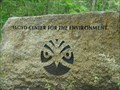 view gallery view gallery N13.2 km N13.2 km
|  Lloyd Center for the Environment Lloyd Center for the Environment
in Nature Centers The Lloyd Center provides education about coastal and watershed issues. They also conduct research on local ecosystems and endangered species. posted by: krystenlc location: Massachusetts date approved: 06/21/2009 last visited: 11/27/2010 |
 view gallery view galleryNW13.8 km |  Horseneck Beach State Reservation - Westport, MA Horseneck Beach State Reservation - Westport, MA
in Beaches Horseneck Beach is a beautiful south facing beach that is a very popular destination. posted by: NorStar location: Massachusetts date approved: 09/28/2015 last visited: never |
 view gallery view galleryN14.2 km |  WII-19 Salvador's Ice Cream WII-19 Salvador's Ice Cream
in Odd-Shaped Buildings Salvadore's Ice Cream posted by: Wayfarer II location: Massachusetts date approved: 10/20/2005 last visited: 11/27/2010 |
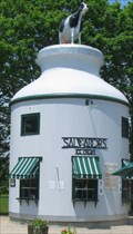
 view gallery view galleryN17.4 km |  Huge Ice Cream Bucket - Dartmouth MA Huge Ice Cream Bucket - Dartmouth MA
in Ginormous Everyday Objects 3 Story Ice Cream place built to represent an ice cream bucket posted by: nomadwillie location: Massachusetts date approved: 03/13/2017 last visited: never |
 view gallery view galleryN17.4 km |  Gulf Hill Ice Cream - Dartmouth MA Gulf Hill Ice Cream - Dartmouth MA
in Roadside Attractions Iconic Ice Cream place on Gulf Road posted by: nomadwillie location: Massachusetts date approved: 03/16/2017 last visited: never |
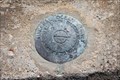 view gallery view galleryN18.2 km |  7712 E - Fort Rodman - New Bedford, MA 7712 E - Fort Rodman - New Bedford, MA
in U.S. Benchmarks This station is located SE of the Fort Rodmen (the stone fort) near the sea wall. posted by: Lat34North location: Massachusetts date approved: 11/02/2014 last visited: 09/04/2014 |
 view gallery view galleryN18.3 km |  Fort Taber District - New Bedford, MA Fort Taber District - New Bedford, MA
in U.S. National Register of Historic Places Fort Taber District is located at the end of Rodney French Blvd, New Bedford, MA. The area around the fort is now a park, the fort its self is NOT open to the public. posted by: Lat34North location: Massachusetts date approved: 10/30/2014 last visited: 02/04/2016 |
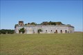 view gallery view galleryN18.3 km |  Fort Rodman - New Bedford, MA Fort Rodman - New Bedford, MA
in Wikipedia Entries Fort Rodman is located at the end of Rodney French Blvd, New Bedford, MA. The area around the fort is now a park, the fort its self is NOT open to the public. posted by: Lat34North location: Massachusetts date approved: 10/29/2014 last visited: 02/04/2016 |
 view gallery view galleryN18.3 km |  Fort Rodman - New Bedford, MA Fort Rodman - New Bedford, MA
in Historic Forts Fort Rodman is located at the end of Rodney French Blvd, New Bedford, MA. The area around the fort is now a park, the fort its self is NOT open to the public. posted by: Lat34North location: Massachusetts date approved: 11/01/2014 last visited: 02/04/2016 |
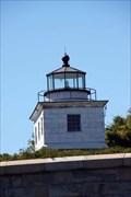 view gallery view galleryN18.3 km | Clarks Point Light - Fort Rodman - New Bedford, MA in Wikipedia Entries Clarks Point Light is located on top of Fort Rodman. Fort Rodman is located at the end of Rodney French Blvd, New Bedford, MA. The area around the fort is now a park, the fort its self is NOT open to the public. posted by: Lat34North location: Massachusetts date approved: 10/30/2014 last visited: 02/04/2016 |
 view gallery view galleryN18.3 km |  Clarks Point Light - Fort Rodman - New Bedford, MA Clarks Point Light - Fort Rodman - New Bedford, MA
in Coastal Lighthouses Clarks Point Light is located on top of Fort Rodman. Fort Rodman is located at the end of Rodney French Blvd, New Bedford, MA. The area around the fort is now a park, the fort its self is NOT open to the public. posted by: Lat34North location: Massachusetts date approved: 10/30/2014 last visited: 05/27/2023 |
 view gallery view galleryN18.3 km | LW4895 - Clarks Point Lighthouse - New Bedford, MA in U.S. Benchmarks Clarks Point Light is located on top of Fort Rodman. Fort Rodman is located at the end of Rodney French Blvd, New Bedford, MA. The area around the fort is now a park, the fort its self is NOT open to the public. posted by: Lat34North location: Massachusetts date approved: 10/29/2014 last visited: 02/04/2016 |
 view gallery view galleryN18.3 km |  Defending a rich target - Fort Taber Park - New Bedford, MA Defending a rich target - Fort Taber Park - New Bedford, MA
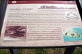
in Massachusetts Historical Markers In 1840, the Army board of engineers met in Boston to plan a defense of the Atlantic Coast. Located at Fort Taber Park on S Rodney French Blvd, New Bedford, MA. posted by: Lat34North location: Massachusetts date approved: 11/07/2014 last visited: 09/04/2014 |
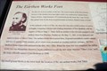 view gallery view galleryN18.3 km | The Earthen Works Fort - Fort Taber Park - New Bedford, MA in Massachusetts Historical Markers On this site stood an earthen works fort. The exact location of the Fort is known because of the detailed drawing (right) which was rendered by Capt. Henry Martyn Robert. Located at Fort Taber Park on S Rodney French Blvd, New Bedford, MA. posted by: Lat34North location: Massachusetts date approved: 11/07/2014 last visited: 09/04/2014 |
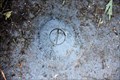 view gallery view galleryN18.3 km | 7712 G - Fort Rodman - New Bedford, MA in U.S. Benchmarks Located in the SE Corner of the bottom step of Battery Barton Walcott NO.2, Fort Rodman Park, New Bedford, MA. posted by: Lat34North location: Massachusetts date approved: 11/03/2014 last visited: 11/04/2014 |
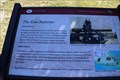 view gallery view galleryN18.5 km | The East Batteries - Fort Taber Park - New Bedford, MA in Massachusetts Historical Markers These batteries are examples of the Endicott Taft Era (1899-1916) coastal defense installations. Located at Fort Taber Park on S Rodney French Blvd, New Bedford, MA. posted by: Lat34North location: Massachusetts date approved: 11/07/2014 last visited: 09/04/2014 |
 view gallery view galleryN18.5 km |  The East Batteries - Fort Taber Park - New Bedford, MA The East Batteries - Fort Taber Park - New Bedford, MA
in 'You Are Here' Maps This "you are here" map is part of the "East Batteries" historic marker located at Fort Taber / Fort Rodman Park in New Bedford, MA. posted by: Lat34North location: Massachusetts date approved: 11/02/2014 last visited: 09/04/2014 |
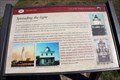 view gallery view galleryN18.5 km | Spreading the Light - Fort Taber Park - New Bedford, MA in Massachusetts Historical Markers The history of two lighthouse. Located at Fort Taber Park on S Rodney French Blvd, New Bedford, MA. posted by: Lat34North location: Massachusetts date approved: 11/07/2014 last visited: 09/04/2014 |
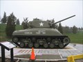 view gallery view galleryN18.5 km |  Sherman Tank -- Fort Taber, New Bedford, Massachusetts Sherman Tank -- Fort Taber, New Bedford, Massachusetts
in Military Ground Equipment Displays A Sherman tank, honoring those who died in Exercise Tiger, a preparation for D-Day. posted by: Shorelander location: Massachusetts date approved: 05/02/2007 last visited: 02/04/2016 |
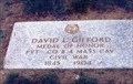 view gallery view galleryN18.5 km |  David L. Gifford-Dartmouth, MA David L. Gifford-Dartmouth, MA
in Medal Of Honor Resting Places Civil War Medal of Honor Recipient for action at Ashepoo River, SC on May 24, 1864.
He is buried in South Dartmouth Cemetery, Dartmouth, MA in Lot 390. posted by: Don.Morfe location: Massachusetts date approved: 08/29/2018 last visited: 12/09/2021 |
 view gallery view galleryN18.5 km |  South Dartmouth Cemetery - South Dartmouth MA South Dartmouth Cemetery - South Dartmouth MA
in Worldwide Cemeteries Privately owned cemetery established in 1764 posted by: nomadwillie location: Massachusetts date approved: 12/26/2015 last visited: never |
|