 view gallery view gallery W6.4 km W6.4 km
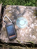
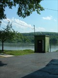
|   P.D.H. Elevation Control Marker over Chilliquaque Creek P.D.H. Elevation Control Marker over Chilliquaque Creek
in U.S. Benchmarks P.D.H. Elevation Control Marker located on the bridge of Chilliquaque Creek. posted by:  redtailforester redtailforester location: Pennsylvania date approved: 07/12/2010 last visited: never |
 view gallery view gallery E7.4 km E7.4 km
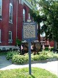
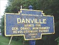
|  Christopher Sholes - Danville, PA Christopher Sholes - Danville, PA
in Pennsylvania Historical Markers Marker noting the connection between Danville & the inventor of the typewiter - the man responsible for 'QWERTY'! posted by:  Ernmark Ernmark location: Pennsylvania date approved: 06/27/2008 last visited: 07/06/2010 |
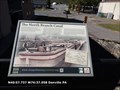
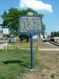 view gallery view galleryE7.6 km | First Iron Rails - Danville, PA in Pennsylvania Historical Markers Marker noting the site of the 1st rolling mill to manufacture iron RR rails. posted by: Ernmark location: Pennsylvania date approved: 06/27/2008 last visited: never |
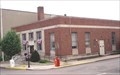
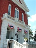 view gallery view galleryE7.6 km |  Montour County Courthouse - Danville, PA Montour County Courthouse - Danville, PA
in Courthouses The courthouse located in the County Seat of Montour County posted by: Ernmark location: Pennsylvania date approved: 07/01/2008 last visited: never |
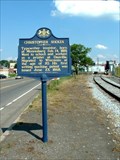
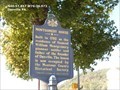
 view gallery view galleryE7.6 km | Montour County - Danville, PA in Pennsylvania Historical Markers Marker located in Danville - noting the origins of Montour County. posted by: Ernmark location: Pennsylvania date approved: 06/27/2008 last visited: 08/14/2010 |
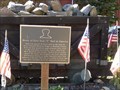 view gallery view galleryE7.6 km |  Home of First Iron "T" Rail in America - Danville PA Home of First Iron "T" Rail in America - Danville PA
in Signs of History Mine car typical of those used in the iron ore mines beneath Montour Ridge in Montour County. posted by: Don.Morfe location: Pennsylvania date approved: 04/10/2020 last visited: 09/27/2021 |
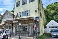
 view gallery view galleryE7.7 km |  Danville, Pennsylvania - 17821 Danville, Pennsylvania - 17821
in U.S. Post Offices Danville Post Office is located in Danville Borough, Montour County, Pennsylvania.
posted by: deano1943 location: Pennsylvania date approved: 06/02/2007 last visited: 06/02/2007 |
 view gallery view galleryE7.7 km | USGS 01540500 Gaging Station Reference Mark - Danville, PA in U.S. Benchmarks USGS Gaging Station Reference Mark disk about 15 feet W of the station building along the Susquehanna River in Danville. posted by: Ernmark location: Pennsylvania date approved: 06/24/2008 last visited: never |
 view gallery view galleryE7.7 km |  USGS 01540500 Susquehanna River at Danville, PA USGS 01540500 Susquehanna River at Danville, PA
in River Gauges USGS Gauging Station located on the N bank of the Susquehanna River in Danville. posted by: Ernmark location: Pennsylvania date approved: 06/23/2008 last visited: never |
 view gallery view galleryE7.7 km | The North Branch Canal - Danville PA in Signs of History The North Branch Canal was surveyed in 1826-27 with construction of the canal between Northumberland and Nanticoke beginning in 1828. posted by: Don.Morfe location: Pennsylvania date approved: 04/10/2020 last visited: 09/27/2021 |
 view gallery view galleryE7.7 km | Montgomery House in Pennsylvania Historical Markers Built in 1792 as the residence of General William Montgomery posted by: Don.Morfe location: Pennsylvania date approved: 05/03/2020 last visited: 10/19/2021 |
 view gallery view gallery N8 km N8 km
| Washingtonville, PA 17884 in U.S. Post Offices Located at 1229 Water St posted by: nomadwillie location: Pennsylvania date approved: 11/07/2019 last visited: never |
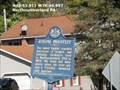
 view gallery view galleryE8.9 km |  Blue Plaque: Danville Blue Plaque: Danville
in Blue Plaques This Blue Plaque is located at the borough line of Danville, in Montour County, Pennsylvania.
posted by: deano1943 location: Pennsylvania date approved: 05/30/2007 last visited: 05/29/2007 |
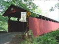
 view gallery view galleryW9.7 km |  Rishel Covered Bridge Rishel Covered Bridge
in Covered Bridges Rishel Covered Bridge is located on Covered Bridge Road between West Chillisquaque and East Chillisquaque Township's in Northumberland County, Pennsylvania.
posted by: deano1943 location: Pennsylvania date approved: 06/04/2007 last visited: 10/21/2010 |
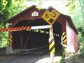 view gallery view galleryW9.7 km |  Rishel Covered Bridge Rishel Covered Bridge
in U.S. National Register of Historic Places Rishel Covered Bridge is located on Covered Bridge Road between West Chillisquaque and East Chillisquaque Township's in Northumberland County, Pennsylvania. posted by: deano1943 location: Pennsylvania date approved: 06/04/2007 last visited: 10/21/2010 |
 view gallery view galleryW10.5 km | Sodom School in Pennsylvania Historical Markers Marker located at the site of the Sodom school. posted by: IV_Warrior location: Pennsylvania date approved: 06/09/2006 last visited: 05/17/2020 |
 view gallery view galleryW10.5 km |  Sodom School Sodom School
in Octagon Buildings An octgaonal schoolhouse posted by: ODragon location: Pennsylvania date approved: 08/31/2007 last visited: 01/03/2015 |
 view gallery view gallery SW11.4 km SW11.4 km
| Joseph Priestley in Pennsylvania Historical Markers The noted English scientist, discoverer of oxygen, and Unitarian theologian lived in Northumberland, 1794 to 1804. posted by: Don.Morfe location: Pennsylvania date approved: 05/10/2020 last visited: 10/19/2021 |
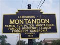 view gallery view galleryW12.1 km | Blue Plaque: Montandon in Blue Plaques This Blue Plaque is located at the borough line of Montandon, in Northumberland County, Pennsylvania. posted by: deano1943 location: Pennsylvania date approved: 07/23/2008 last visited: 05/17/2009 |
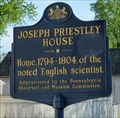 view gallery view gallerySW12.6 km | Joseph Priestley House - Northumberland PA in Pennsylvania Historical Markers The Joseph Priestley House was the American home of 18th-century British theologian, Dissenting clergyman, natural philosopher (and discoverer of oxygen), educator, and political theorist. posted by: nomadwillie location: Pennsylvania date approved: 07/02/2015 last visited: never |
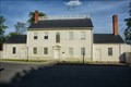 view gallery view gallerySW12.6 km | Priestley, Joseph, House - Northumberland PA in U.S. National Register of Historic Places The Joseph Priestley House was the American home of 18th-century British theologian, Dissenting clergyman, natural philosopher (and discoverer of oxygen), educator, and political theorist. posted by: nomadwillie location: Pennsylvania date approved: 05/28/2015 last visited: never |
 view gallery view gallery S12.6 km S12.6 km
| Keefer Station Covered Bridge in Covered Bridges Keefer Station Covered Bridge is located on Mill Road (T 698) approximately 5 miles east of Sunbury, in Upper Augusta Township, Northumberland County, Pennsylvania.
posted by: deano1943 location: Pennsylvania date approved: 06/02/2007 last visited: 06/02/2007 |
 view gallery view galleryS12.6 km | Keefer Station Covered Bridge in U.S. National Register of Historic Places Keefer Station Covered Bridge is located on Mill Road (T 698) approximately 5 miles east of Sunbury, in Upper Augusta Township, Northumberland County, Pennsylvania. posted by: deano1943 location: Pennsylvania date approved: 06/02/2007 last visited: 06/02/2007 |
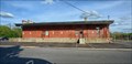 view gallery view gallerySW12.7 km |  Lackawanna Freight Station - Northumberland PA Lackawanna Freight Station - Northumberland PA
in Train Stations/Depots Built in 1911 for the Lackawana RR. posted by: nomadwillie location: Pennsylvania date approved: 05/28/2015 last visited: never |
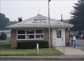 view gallery view galleryW13 km | Montandon, Pennsylvania - 17850 in U.S. Post Offices Montandon Post office is located in Northumberland County, Pennsylvania. posted by: deano1943 location: Pennsylvania date approved: 07/22/2008 last visited: 05/17/2009 |
|