 view gallery view gallery NE0 km NE0 km
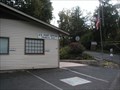
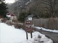
|   Erwinna Pa. 18920 Erwinna Pa. 18920
in U.S. Post Offices An interesting 50 style building in an great old canal town. Erwinna (pronounced ar-WIN-na) is an unincorporated community in Tinicum Township, Bucks County, Pennsylvania, United States, 39 Headquarters Rd. Erwinna posted by:  mars888 mars888 location: Pennsylvania date approved: 09/15/2013 last visited: 08/11/2013 |
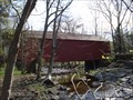
 view gallery view gallery SW0.2 km SW0.2 km
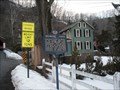
|  Delaware Valley Volunteer Fire Co. Delaware Valley Volunteer Fire Co.
in Firehouses Nice newer station & company just uphill from a grand old canal town.
EMS seems to be limited to EMTs on water rescue craft. posted by: mars888 location: Pennsylvania date approved: 09/15/2013 last visited: 05/23/2009 |
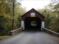
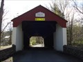
 view gallery view gallery NW0.3 km NW0.3 km
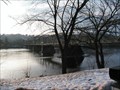
|  Erwinna Covered Bridge - Erwinna, PA Erwinna Covered Bridge - Erwinna, PA
in Wikipedia Entries "The Erwinna Covered Bridge is a wooden covered bridge that spans Swamp Creek in Erwinna, Pennsylvania, United States.
The bridge was constructed using a lattice-type design.
In winter the bridge is decorated with lights and a wreaths"
Wikipedia posted by: mars888 location: Pennsylvania date approved: 09/16/2013 last visited: 08/16/2014 |
 view gallery view gallery N1.1 km N1.1 km
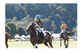
| Tinicum Park, Erwinna, PA in Wikipedia Entries Wonderful park between the Delaware River & Canal in historic & scenic area. Offers Boating, camping, picnic, historic house tours, polo on summer Saturdays, Frisbee golf, camping, art & other events, & lots more. Source: Buckscounty.org posted by: mars888 location: Pennsylvania date approved: 02/13/2014 last visited: 08/25/2022 |
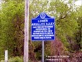 view gallery view galleryNE2.3 km |  Lower Argillite Alley Lower Argillite Alley
in New Jersey Historical Markers Lenape tribes used this abundant Hunterdon mineral for spearpoints and tools. posted by:  Don.Morfe Don.Morfe location: New Jersey date approved: 05/17/2020 last visited: 10/14/2021 |
 view gallery view galleryN2.7 km | Uhlerstown, PA Historic District in Wikipedia Entries "Uhlerstown Historic District includes 63 contributing buildings, 4 contributing sites, and 16 contributing structures along the Delaware Division of the Pennsylvania Canal centered on the village of Uhlerstown." Wikipedia posted by: mars888 location: Pennsylvania date approved: 03/10/2014 last visited: 06/14/2014 |
 view gallery view galleryN2.7 km |  Uhlerstown Covered Bridge - Uhlerstown Hill Rd. Uhlerstown, PA Uhlerstown Covered Bridge - Uhlerstown Hill Rd. Uhlerstown, PA
in Covered Bridges Uhlerstown Covered Bridge is in a tiny town near a lock along the Delaware Canal State Park. It has a great recreational path & interpretive signs along the canal in the area. The town & canal are nestled between a cliff on one side & farm fields. posted by: mars888 location: Pennsylvania date approved: 03/10/2014 last visited: 06/14/2014 |
 view gallery view galleryN2.7 km | Uhlerstown, PA in Wikipedia Entries Uhlerstown is a remarkable tiny community & lock along the Delaware Canal State Park. It has a great recreational path & interpretive signs along the canal in the area. The community & lock are nestled beneath a cliff like hill & wide farm fields. posted by: mars888 location: Pennsylvania date approved: 03/10/2014 last visited: 06/14/2014 |
 view gallery view galleryN2.9 km | Uhlerstown, PA – Frenchtown, NJ Bridge in Wikipedia Entries A scenic 950’ bridge across the Delaware River between a great tourist stop, Frenchtown, NJ & Uhlerstown PA. a quaint tiny farm town that grew up around the Mexico Lock on the Delaware Canal. Great views of the river from the sidewalk. posted by: mars888 location: Pennsylvania date approved: 03/10/2014 last visited: 06/14/2014 |
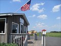 view gallery view gallerySW2.9 km |  Van Sant Airport - Erwinna PA Van Sant Airport - Erwinna PA
in Airports A great hilltop park & airfield, where classic planes, cars & motorcycles gather on summer weekends for the burgers grilled behind the "shack".
516 Cafferty Rd Erwinna, PA 18920 posted by: mars888 location: Pennsylvania date approved: 06/19/2013 last visited: 10/15/2022 |
 view gallery view gallery S3.2 km S3.2 km
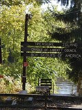
|  Treasure Island Treasure Island
in Boy Scout Camps Treasure Island is the oldest continually operated Boy Scout Camp in the country. It is naturally divided into Marshall Island and Treasure Island by the Delaware River near Pipersville, PA. Treasure Island combines some of the best facilities available with the adventure of "living on an island."
posted by: LowellHouseGuy location: Pennsylvania date approved: 10/19/2005 last visited: 05/09/2007 |
 view gallery view galleryS3.4 km |  Treasure Island Reservation Treasure Island Reservation
in Pennsylvania Historical Markers Order of the Arrow posted by: Gosffo location: Pennsylvania date approved: 03/10/2007 last visited: never |
 view gallery view gallerySW3.5 km | Frankenfield Covered Bridge - Cafferty Road Tinnicum Township, PA in Covered Bridges Nice long red bridge on fine country road & creek. posted by: mars888 location: Pennsylvania date approved: 09/17/2013 last visited: 07/27/2013 |
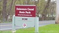 view gallery view galleryN4.3 km |  Delaware Canal State Park - Upper Black Eddy, PA Delaware Canal State Park - Upper Black Eddy, PA
in State/Provincial Parks Delaware Canal State Park is one of the 121 parks that make up the Pennsylvania State Park system. posted by: Janila location: Pennsylvania date approved: 07/05/2018 last visited: never |
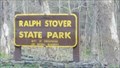 view gallery view galleryS7.1 km | Ralph Stover State Park - Pipersville, PA in State/Provincial Parks Ralph Stover State Park is one of 121 state parks in the Pennsylvania state park system. posted by: Janila location: Pennsylvania date approved: 07/07/2018 last visited: 10/15/2022 |
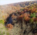 view gallery view galleryS7.2 km |  High Rocks overlook High Rocks overlook
in Scenic Overlooks High rocks is a 200-foot sheer rock face overlooking an oxbow on the Tohickon Creek near the town of Point Pleasant Pennsylvania. posted by: dhmeiser location: Pennsylvania date approved: 08/02/2006 last visited: 10/15/2022 |
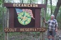 view gallery view galleryS7.6 km | Ockanickon Boy Scout Camp in Boy Scout Camps N 40° 26.040 W 075° 05.320
This Boy Scout Gateway is located near Ralp Stover State Park in PA. This camp is named after a Lenape Native American Tribal Leader. posted by: chstress53 location: Pennsylvania date approved: 10/21/2005 last visited: 10/23/2011 |
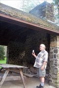 view gallery view galleryS7.6 km |  Picnic Shelter at Ralph Stover State Park Picnic Shelter at Ralph Stover State Park
in Civilian Conservation Corps This Picnic shelter in Ralph Stover State Park was indeed built by the Civilian Conservation Corp. posted by: chstress53 location: Pennsylvania date approved: 10/21/2005 last visited: 07/27/2013 |
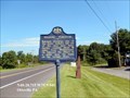 view gallery view gallery W8.2 km W8.2 km
| Walking Purchase in Pennsylvania Historical Markers Solomon Jennings, one of the three walkers, fell out of the race near here, having covered about 19 miles from Wrightstown. posted by: Don.Morfe location: Pennsylvania date approved: 05/10/2020 last visited: 10/19/2021 |
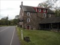 view gallery view gallerySW8.2 km | Stover-Myers Mill - Bedminster Township, PA in Wikipedia Entries A good & underused county park with mills, buildings, sledding, nice creek front, parking, hills, history, tours, living history,fishing, etc. posted by: mars888 location: Pennsylvania date approved: 09/16/2013 last visited: 09/21/2013 |
 view gallery view gallerySW8.4 km | Cabin Run Bridge - Smith's Corners, PA in Covered Bridges Cabin Run Bridge is appropriately named, crossing the Cabin Run near where it empties into the Tohickon Creek. posted by: Lightnin Bug location: Pennsylvania date approved: 04/18/2010 last visited: 06/01/2013 |
 view gallery view gallerySW8.4 km |  Cabin Run Bridge - Smith's Corners, PA Cabin Run Bridge - Smith's Corners, PA
in U.S. National Register of Historic Places Cabin Run Bridge is appropriately named, crossing the Cabin Run near where it empties into the Tohickon Creek. posted by: Lightnin Bug location: Pennsylvania date approved: 04/18/2010 last visited: 02/15/2012 |
 view gallery view galleryN8.4 km | Milford - Milford NJ in New Jersey Historical Markers Grist mill and several houses here in mid 1700's. Known as Burnt Mills after fire in 1769. Ferry to Pennsylvania here until 1842 when a bridge was built. posted by: Don.Morfe location: New Jersey date approved: 06/05/2020 last visited: 10/14/2021 |
 view gallery view galleryNW8.4 km |  Ringing Rocks Park - Upper Black Eddy, PA Ringing Rocks Park - Upper Black Eddy, PA
in Satellite Imagery Oddities In this park is a 7-8 acre field of boulders that have an unusual property. When struck with a hammer or another rock, the rocks sound as if they are metal and hollow and ring with a sound similar to a metal pipe being struck. posted by: Math Teacher location: Pennsylvania date approved: 08/14/2013 last visited: 07/19/2009 |
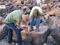 view gallery view galleryNW8.4 km |  Ringing Rocks Park - Upper Black Eddy, PA Ringing Rocks Park - Upper Black Eddy, PA
in Roadside Attractions In this park is a 7-8 acre field of boulders that have an unusual property. When struck with a hammer or another rock, the rocks sound as if they are metal and hollow and ring with a sound similar to a metal pipe being struck. posted by: Math Teacher location: Pennsylvania date approved: 08/18/2010 last visited: 07/19/2009 |
|