 view gallery view gallery NE2.6 km NE2.6 km
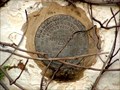
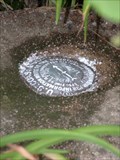
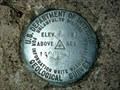
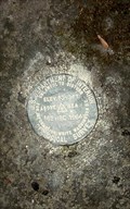
|   C-11 USGS - Doylesburg, PA C-11 USGS - Doylesburg, PA
in U.S. Benchmarks USGS benchmark located in the SW corner of a former hotel in Doylesburg, PA. posted by:  Ernmark Ernmark location: Pennsylvania date approved: 09/12/2007 last visited: never |
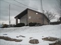
 view gallery view gallery SW5.8 km SW5.8 km
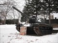
|  M 60 Tank - Dry Run, PA M 60 Tank - Dry Run, PA
in Military Ground Equipment Displays Part of the James W. McCartney Veterans Memoral near Dry Run, PA. posted by:  jdb&scb jdb&scb location: Pennsylvania date approved: 06/03/2010 last visited: never |
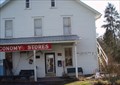
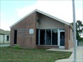
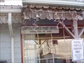 view gallery view gallerySW7.4 km |  Spring Run, Pennsylvania - 17262 Spring Run, Pennsylvania - 17262
in U.S. Post Offices Spring Run Post Office is situated in Franklin County, Pennsylvania. posted by: deano1943 location: Pennsylvania date approved: 11/30/2008 last visited: 01/05/2010 |
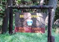 view gallery view galleryNE9 km |  Big Spring State Forest Picnic Area - Perry County, Pennsylvania Big Spring State Forest Picnic Area - Perry County, Pennsylvania
in State/Provincial Parks Tucked in the side of Conococheague Mountain, Big Spring State Forest Picnic Area is a quaint picnic and hiking area. (Toboyne Township, Perry County, Pennsylvania) posted by: outdoorboy34 location: Pennsylvania date approved: 11/14/2012 last visited: 03/29/2019 |
 view gallery view gallerySW9 km |  NEELYTON AZ - Neelyton, PA NEELYTON AZ - Neelyton, PA
in Azimuth Benchmarks Azimuth Mark for Triangulation Station 'Neelyton' located at the top of the mountain 0.8 mi. to the SE. posted by: Ernmark location: Pennsylvania date approved: 07/15/2008 last visited: never |
 view gallery view gallerySW9.3 km | PTC 191.6 - Franklin County, PA in U.S. Benchmarks PA Turnpike Commission disk located near mile marker 191.6 on the N (westbound) side of the highway. posted by: Ernmark location: Pennsylvania date approved: 01/04/2007 last visited: 10/09/2009 |
 view gallery view gallerySW9.7 km | Neelyton, Pennsylvania - 17239 in U.S. Post Offices Neelyton Post Office is situated in Huntingdon County, Pennsylvania. posted by: deano1943 location: Pennsylvania date approved: 11/30/2008 last visited: 11/30/2008 |
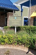 view gallery view gallery SE10.1 km SE10.1 km
|  Blue Mountain Rest Area - I-70 - Newburg, PA Blue Mountain Rest Area - I-70 - Newburg, PA
in Blue Star Memorial Highway Markers Blue Star Memorial marker on the front side of the Blue Mountain I76 westbound rest area. posted by: Janila location: Pennsylvania date approved: 07/31/2018 last visited: never |
 view gallery view gallerySE10.5 km | PTC 201.2 - Franklin County, PA in U.S. Benchmarks PA Turnpike Commission disk located at the entrance to the Blue Mountain Interchange (Exit 201) of the Turnpike. posted by: Ernmark location: Pennsylvania date approved: 01/04/2007 last visited: never |
 view gallery view gallerySE10.9 km | 749 USGS - Roxbury, PA in U.S. Benchmarks Aluminum disk located in the sidewalk in front of a small store in Roxbury, PA. posted by: Ernmark location: Pennsylvania date approved: 08/12/2007 last visited: 02/11/2010 |
 view gallery view gallerySW10.9 km | Willow Hill, PA 17271 in U.S. Post Offices This Post Office is located at 14413 Path Valley Road. Zip Code is 17271. posted by: jdb&scb location: Pennsylvania date approved: 01/06/2010 last visited: never |
 view gallery view gallerySE11.1 km | Roxbury, PA 17251 in U.S. Post Offices Post Office located in the town of Roxbury in northern Franklin County. posted by: Ernmark location: Pennsylvania date approved: 08/11/2007 last visited: never |
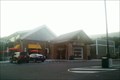
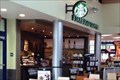 view gallery view gallery E11.1 km E11.1 km
|  Starbucks #88731 - Blue Mountain Service Plaza - Newburg, Pennsylvania Starbucks #88731 - Blue Mountain Service Plaza - Newburg, Pennsylvania
in Starbucks Stores This Starbucks is located within the Blue Mountain Service Plaza, which is accessible via the Pennsylvania Turnpike at Milepost 202.5 (Interstate 76) westbound in Hopewell Township, Cumberland County, Pennsylvania posted by: outdoorboy34 location: Pennsylvania date approved: 05/10/2013 last visited: 07/29/2018 |
 view gallery view galleryE11.1 km |  Blue Mountain Service Plaza - Newburg, Pennsylvania Blue Mountain Service Plaza - Newburg, Pennsylvania
in Highway Rest Areas The Blue Mountain Service Plaza serves westbound traffic at Milepost 202.5 on Interstate 76 of the Pennsylvania Turnpike and is located in Hopewell Township, Cumberland County, Pennsylvania posted by: outdoorboy34 location: Pennsylvania date approved: 05/09/2013 last visited: 07/29/2018 |
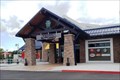 view gallery view galleryE11.1 km |  Blue Mountain Service Plaza - Newburg, Pennsylvania Blue Mountain Service Plaza - Newburg, Pennsylvania
in Wi-Fi Hotspots FREE Wi-Fi is served around the clock at the Blue Mountain Service Plaza, located at Milepost 202.5 Westbound of the Pennsylvania Turnpike (Interstate 76) in Hopewell Township, Cumberland County, Pennsylvania posted by: outdoorboy34 location: Pennsylvania date approved: 05/13/2013 last visited: 07/29/2018 |
 view gallery view gallerySE11.3 km |  McKinney, PA population 68 McKinney, PA population 68
in Population Signs This sign welcomes travellers to Mc Kinney, a section of Newburg. posted by: r.e.s.t.seekers location: Pennsylvania date approved: 07/10/2022 last visited: 08/14/2022 |
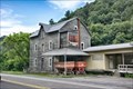 view gallery view gallery W12.6 km W12.6 km
|  Shade Gap Feed and Flour Mill - Shade Gap PA Shade Gap Feed and Flour Mill - Shade Gap PA
in U.S. National Register of Historic Places Shade Gap Feed and Flour Mill, also known as C.J. Hess Mill was built in 1846. The mill ceased operation in 1973–74, but continues as a livestock feed mill. posted by: nomadwillie location: Pennsylvania date approved: 03/11/2023 last visited: never |
 view gallery view galleryW12.6 km |  Shade Gap Feed and Flour Mill - Shade Gap PA Shade Gap Feed and Flour Mill - Shade Gap PA
in Wikipedia Entries Shade Gap Feed and Flour Mill, also known as C.J. Hess Mill was built in 1846. The mill ceased operation in 1973–74, but continues as a livestock feed mill. posted by: nomadwillie location: Pennsylvania date approved: 03/09/2023 last visited: never |
 view gallery view galleryW12.6 km |  Shade Gap Feed and Flour Mill - Shade Gap PA Shade Gap Feed and Flour Mill - Shade Gap PA
in Mills and Gins Brice X. Blair erected this grist mill in 1846. Blair sold the mill in 1854 to Mathias Shoop, who added an "engine and fixtures " (presumably a steam engine) to the mill's water-powered wheel. posted by: nomadwillie location: Pennsylvania date approved: 03/09/2023 last visited: never |
 view gallery view galleryW12.6 km |  Shade Gap Feed and Flour Mill - Shade Gap PA Shade Gap Feed and Flour Mill - Shade Gap PA
in Water Mills Brice X. Blair erected this grist mill in 1846. Blair sold the mill in 1854 to Mathias Shoop, who added an "engine and fixtures " (presumably a steam engine) to the mill's water-powered wheel. posted by: nomadwillie location: Pennsylvania date approved: 03/09/2023 last visited: never |
 view gallery view galleryW12.7 km | Shade Gap, Pennsylvania - 17255 in U.S. Post Offices Shade Gap Post Office is situated in Huntingdon County, Pennsylvania. posted by: deano1943 location: Pennsylvania date approved: 11/30/2008 last visited: 11/30/2008 |
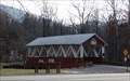 view gallery view galleryW12.9 km |  St. Mary's Covered Bridge - Orbisonia, PA St. Mary's Covered Bridge - Orbisonia, PA
in Truss Bridges The St. Mary's Covered bridge is the last remaining covered bridge in Huntingdon County, PA. posted by: Janila location: Pennsylvania date approved: 12/23/2018 last visited: 03/09/2023 |
 W13.2 km |  Shadow of Death Shadow of Death
in Pennsylvania Historical Markers Not a lot of extra space on the shoulder, use caution when visiting this one. posted by: IV_Warrior location: Pennsylvania date approved: 06/13/2006 last visited: 12/17/2018 |
 view gallery view galleryE13.2 km | 162 HBC 1964 - Three Square Hollow - Cumberland County, PA in U.S. Benchmarks Benchmark located on Blue Mountain in Three Square Hollow.
posted by: Ernmark location: Pennsylvania date approved: 04/03/2008 last visited: never |
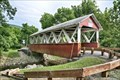 view gallery view galleryW13.4 km | St. Mary's Covered Bridge - Orbisonia, PA in Wikipedia Entries The St. Mary's Covered Bridge is a 65.25-foot-long (19.89 m) 16.5-foot-wide (5.0 m), Howe truss bridge with cut stone abutments, constructed in 1889. posted by: nomadwillie location: Pennsylvania date approved: 03/09/2023 last visited: never |
|