 view gallery view gallery S6.9 km S6.9 km
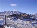
|   Canyon Station Canyon Station
in Pony Express Monuments Canyon Station Ruins located in Overland Canyon near Ibapah, Utah posted by:  caverspencer caverspencer location: Utah date approved: 02/16/2007 last visited: 11/30/2008 |
 view gallery view gallery N6.9 km N6.9 km
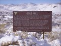
|  Gold Hill, Utah Gold Hill, Utah
in Ghost Towns Gold Hill posted by: caverspencer location: Utah date approved: 02/16/2007 last visited: never |
 view gallery view gallery SW16.1 km SW16.1 km
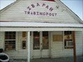
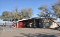
|  Ibapah Trading Post Ibapah Trading Post
in Payphones Working Payphone located at the Ibapah Trading post in Ibapah Utah. There is no cell service here so this is the only link to the outside world. posted by: caverspencer location: Utah date approved: 02/25/2007 last visited: never |
 view gallery view gallery W68.9 km W68.9 km
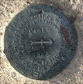
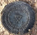
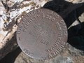
|  LQ0655 - USCGS LAGES NO 1 - 1965 - Nevada LQ0655 - USCGS LAGES NO 1 - 1965 - Nevada
in U.S. Benchmarks U.S. Coast & Geodetic Survey reference mark LAGES NO 1. posted by:  Volcanoguy Volcanoguy location: Nevada date approved: 12/24/2016 last visited: 09/28/2016 |
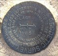
 view gallery view galleryW68.9 km | LQ0655 - USCGS LAGES - 1965 - Nevada in U.S. Benchmarks U.S. Coast & Geodetic Survey triangulation station LAGES. posted by: Volcanoguy location: Nevada date approved: 12/24/2016 last visited: 09/28/2016 |
 view gallery view galleryW68.9 km | LQ0655 - USCGS LAGES NO 2 - 1965 - Nevada in U.S. Benchmarks U.S. Coast & Geodetic Survey reference mark LAGES NO 2. posted by: Volcanoguy location: Nevada date approved: 12/24/2016 last visited: 09/28/2016 |
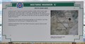
 view gallery view galleryN70.3 km |  First Transcontinental Telephone Line First Transcontinental Telephone Line
in First of its Kind The final splices in the first transcontinental telephone line were completed near Wendover, Utah. posted by: brwhiz location: Utah date approved: 04/08/2012 last visited: 09/26/2016 |
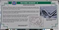
 view gallery view galleryN70.3 km |  First Transcontinental Telephone Line First Transcontinental Telephone Line
in Utah Historical Markers The final splices in the first transcontinental telephone line were completed near Wendover, Utah. posted by: brwhiz location: Utah date approved: 04/09/2012 last visited: 09/26/2016 |
 view gallery view galleryN70.3 km |  Salt Flats East Rest Area - Wendover, Utah Salt Flats East Rest Area - Wendover, Utah
in Blue Star Memorial Highway Markers Located along Interstate 80 at the East Bound Salt Flats Rest Area posted by: Lord Mot location: Utah date approved: 06/26/2011 last visited: 06/19/2015 |
 view gallery view galleryN70.3 km |  Salt Flats East Rest Area ~ Wendover, Utah Salt Flats East Rest Area ~ Wendover, Utah
in Highway Rest Areas This Interstate 80 Rest Area is located several miles east of the Nevada/Utah border and the towns of Wendover, Utah and West Wendover, Nevada. posted by: brwhiz location: Utah date approved: 04/09/2012 last visited: 06/17/2019 |
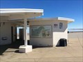
 view gallery view galleryN70.3 km |  Bonneville Salt Flats Bonneville Salt Flats
in Places of Geologic Significance This area known for auto racing and attempts at new land speed records is the bottom of an ancient lake. posted by: brwhiz location: Utah date approved: 04/10/2012 last visited: 06/10/2023 |
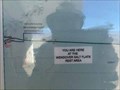
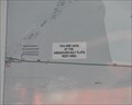 view gallery view galleryN70.3 km |  Salt Flats East Rest Area Salt Flats East Rest Area
in 'You Are Here' Maps You Are Here at the Wendover Salt Flats Rest Area on Eastbound Interstate 80 several miles east of Wendover, Utah. posted by: brwhiz location: Utah date approved: 04/10/2012 last visited: 05/07/2018 |
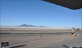 view gallery view galleryN70.3 km |  Bonneville Salt Flats Bonneville Salt Flats
in Roadside Attractions An elevated platform at the Interstate 80 eastbound rest area just east of Wendover, Utah allows long-distance views of the Bonneville Salt Flats Speedway area. posted by: brwhiz location: Utah date approved: 05/04/2012 last visited: 12/22/2022 |
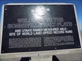
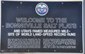 view gallery view galleryN70.3 km | Welcome to the Bonneville Salt Flats - Interstate 80 Eastbound in Utah Historical Markers The Bonneville Salt Flats are just east of Wendover, Utah. posted by: brwhiz location: Utah date approved: 04/22/2011 last visited: 12/22/2022 |
 view gallery view gallery E70.5 km E70.5 km
| 40 by 112 in U.S. Benchmarks A pipe cap in the desert posted by: Will Jeep for Cache location: Utah date approved: 03/22/2007 last visited: 03/17/2007 |
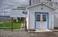
 view gallery view galleryN70.7 km | Salt Flats West Rest Area in 'You Are Here' Maps You Are Here marker at Salt Flats West Rest Area posted by: Volcanoguy location: Utah date approved: 12/19/2016 last visited: 12/22/2022 |
 view gallery view galleryN70.7 km | Salt Flats West Rest Area in Highway Rest Areas Rest area on Westbound Interstate Highway 80 east of Wendover on the Nevada/Utah border. posted by: Volcanoguy location: Utah date approved: 12/19/2016 last visited: 12/22/2022 |
 view gallery view galleryN70.7 km | First man to go faster than 400, 500, and 600 miles per hour - Bonneville Salt Flats - Utah in First of its Kind Craig Breedlove set the record for the first man to go faster than 400 mph. He broke his own record, twice. posted by: Max and 99 location: Utah date approved: 11/07/2018 last visited: 01/19/2023 |
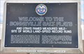 view gallery view galleryN70.7 km | Welcome to the Bonneville Salt Flats - Interstate 80 Westbound in Utah Historical Markers The Bonneville Salt Flats are just east of Wendover, Utah. posted by: brwhiz location: Utah date approved: 04/09/2011 last visited: 12/22/2022 |
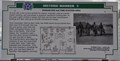 view gallery view galleryN71.6 km | Hangar 835 and Fire Station Area in Utah Historical Markers This is Stop "I" on the self-guided walking/driving tour of the Wendover Air Force Base from which the mission to drop the first atomic bomb originated. A brochure detailing the complete tour is available at the Base Museum, 345 S Airport Apron. posted by: brwhiz location: Utah date approved: 10/03/2012 last visited: 09/01/2018 |
 view gallery view galleryN71.6 km | Atomic Mission Hangar 1831 in Utah Historical Markers This is Stop "J" on the self-guided walking/driving tour of the Wendover Air Force Base from which the mission to drop the first atomic bomb originated. A brochure detailing the complete tour is available at the Base Museum, 345 S Airport Apron. posted by: brwhiz location: Utah date approved: 10/03/2012 last visited: 03/10/2019 |
 view gallery view galleryN71.6 km | South Base Area in Utah Historical Markers This is Stop "C" on the self-guided walking/driving tour of the Wendover Air Force Base from which the mission to drop the first atomic bomb originated. A brochure detailing the complete tour is available at the Base Museum, 345 S Airport Apron. posted by: brwhiz location: Utah date approved: 10/02/2012 last visited: 03/10/2019 |
 view gallery view galleryN71.6 km | Operations Building in Utah Historical Markers This is Stop "A" on the self-guided walking/driving tour of the Wendover Air Force Base from which the mission to drop the first atomic bomb originated. A brochure detailing the complete tour is available at the Base Museum, 345 S Airport Apron. posted by: brwhiz location: Utah date approved: 10/03/2012 last visited: 03/10/2019 |
 view gallery view galleryN71.6 km |  Wendover Air Base ~ Elevation 4230 Wendover Air Base ~ Elevation 4230
in Elevation Signs This Elevation Sign is on the south side of the Wendover Airport Operations Building facing the aircraft apron. posted by: brwhiz location: Utah date approved: 10/03/2012 last visited: 03/10/2019 |
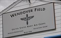
 view gallery view galleryN71.6 km |  Historic Wendover Airfield Historic Wendover Airfield
in Self Guided Walks and Trails This is the starting point for the fifteen stop Historic Wendover Airfield Tour. A brochure detailing the complete tour is available here inside the Base Operations Building. posted by: brwhiz location: Utah date approved: 10/05/2012 last visited: 12/22/2022 |
|