 view gallery view gallery SE1.6 km SE1.6 km
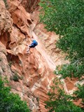
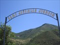
|   Rock Climbing at Red Ledges - Utah Rock Climbing at Red Ledges - Utah
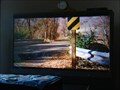
in Established Rock Climbing Areas Rappelling at Red Ledges picnic area in Diamond Fork Canyon. posted by:  The_Simpsons The_Simpsons location: Utah date approved: 03/17/2012 last visited: 04/14/2016 |
 view gallery view gallery SW1.8 km SW1.8 km
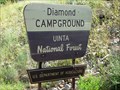
|  Diamond Campground - Uinta National Forest - Utah USA Diamond Campground - Uinta National Forest - Utah USA
in Campgrounds Diamond Campground - Uinta National Forest - Utah USA - The_Simpsons favorite place to camp. posted by: The_Simpsons location: Utah date approved: 07/26/2011 last visited: 04/14/2016 |
 view gallery view gallery E5.6 km E5.6 km
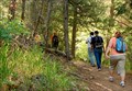
|  Fifth Water Hot Pots Fifth Water Hot Pots
in Scenic Hikes A 2.75 mile (one way) hike to some hot springs pools and a waterfall. posted by: JacobBarlow location: Utah date approved: 08/11/2010 last visited: 03/23/2011 |
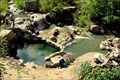 view gallery view galleryE8.7 km |  Fifth Water Hot Pots Fifth Water Hot Pots
in Hot Springs A relatively level 2.75 mile hike will get you to these hot spring pools and waterfall. posted by: JacobBarlow location: Utah date approved: 08/11/2010 last visited: 03/23/2011 |
 view gallery view gallery W9.2 km W9.2 km
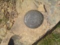
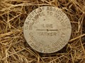
|  Benchmark: LO0779 " SPANISH FORK PEAK " RM NO. 1 Benchmark: LO0779 " SPANISH FORK PEAK " RM NO. 1
in U.S. Benchmarks Reference Mark Number 1 for Benchmark: LO0779 " SPANISH FORK PEAK " posted by: JacobBarlow location: Utah date approved: 12/21/2007 last visited: 07/28/2008 |
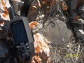
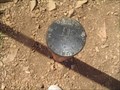 view gallery view galleryW9.2 km | Benchmark: LO0779 " SPANISH FORK PEAK " in U.S. Benchmarks A Pipe Cap Benchmark atop Spanish Fork Peak. posted by: JacobBarlow location: Utah date approved: 12/21/2007 last visited: 07/26/2008 |
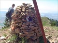 view gallery view galleryW9.2 km | Benchmark: LO0778 " SPANISH FORK CAIRN " in U.S. Benchmarks This cairn is atop Spanish Fork Peak, the highest peak of Maple Mountain, I have hiked here many times, but did not know about Benchmarks. posted by: JacobBarlow location: Utah date approved: 12/21/2007 last visited: 07/28/2008 |
 view gallery view galleryW9.2 km |  Spanish Fork Peak Spanish Fork Peak
in Mountain Summits Spanish Fork Peak is at the top of Maple Mountain, east of Mapleton/Spanish Fork, UT posted by: DrJay location: Utah date approved: 07/18/2006 last visited: 08/11/2010 |
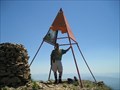
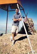 view gallery view galleryW9.2 km |  Spanish Fork Peak Spanish Fork Peak
in Summit Registers The highest point of Maple Mountain. The register is a mailbox in a cairn. posted by: JacobBarlow location: Utah date approved: 08/11/2010 last visited: 11/28/2022 |
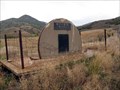
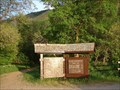
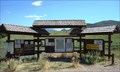 view gallery view gallerySW9.3 km |  Diamond 411 - Traveler Information Kiosk - Utah USA Diamond 411 - Traveler Information Kiosk - Utah USA
in Tourist Information Centers - Visitor Centers Diamond 411 - Traveler Information Kiosk - Diamond Fork Canyon access, Utah posted by: The_Simpsons location: Utah date approved: 08/01/2011 last visited: 04/14/2016 |
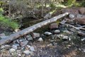 view gallery view gallery NW10.1 km NW10.1 km
|  Footbridge; Maple Canyon Footbridge; Maple Canyon
in Hiking Path Footbridges This is a simple log that has been smoothed to form a footbridge crossing the creek from the Maple Canyon Trail to the start of the Spanish Fork Peak Trailhead. posted by: Toja7 location: Utah date approved: 10/25/2011 last visited: 10/21/2011 |
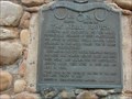 view gallery view galleryNW11.1 km |  The Kelly Ranch The Kelly Ranch
in Utah Historical Markers I've grown up in this area, we had alot of church and community activities at "Kelly's Grove", it's nice to find out why it's called that. posted by: JacobBarlow location: Utah date approved: 03/22/2007 last visited: 08/10/2013 |
 view gallery view galleryNW11.3 km |  Camp Jeremiah Johnson - Springville, Utah Camp Jeremiah Johnson - Springville, Utah
in Boy Scout Camps Utah National Parks Council of the Boy scouts have a great day camp for Cub Scouts, Webelos, Girls & Community. posted by: Mom the Cook & cashnhubby location: Utah date approved: 08/11/2011 last visited: 04/14/2016 |
 view gallery view galleryNW11.3 km | Line Marker near Hobble Creek Golf Course in U.S. Benchmarks We found this Benchmark disc "Line Marker" across the street from the golf course. posted by: JacobBarlow location: Utah date approved: 08/07/2007 last visited: 04/08/2011 |
 view gallery view gallerySW11.4 km | Thistle Junction in U.S. Benchmarks Benchmark on the top of the ridge. posted by: BMars7391 location: Utah date approved: 03/25/2012 last visited: 03/22/2012 |
 view gallery view gallerySW11.6 km | U Pace O Ranch, Thistle, Utah in Utah Historical Markers This land has been farmed since about 1850 and was utilized by native Americans prior to that. posted by: Queens Blessing location: Utah date approved: 10/29/2010 last visited: 05/27/2020 |
 view gallery view galleryNW12.1 km |  Mapleton Great Western Access Trail Mapleton Great Western Access Trail
in Mountain Bike Trailheads A very fun mile long trail for hikers, bikers, runners, and equestrians that goes from the mouth of Maple Canyon to Whiting Campground. posted by: JacobBarlow location: Utah date approved: 08/13/2010 last visited: 10/21/2011 |
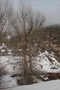
 view gallery view gallerySW12.2 km |  Thistle Ghost Town Thistle Ghost Town
in Ghost Towns Was the town of Thistle Utah posted by: firennice location: Utah date approved: 07/03/2008 last visited: 04/02/2017 |
 view gallery view galleryNW12.4 km |  Maple Canyon Palindrome - Mapleton, Utah Maple Canyon Palindrome - Mapleton, Utah
in Coordinate Palindromes Just off the road up Maple Canyon to Whiting Campground above Mapleton, Utah. posted by: JacobBarlow location: Utah date approved: 02/11/2007 last visited: 04/08/2011 |
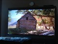 view gallery view galleryNW12.9 km |  Hobble Creek Canyon Barn , "Brigham City" Hobble Creek Canyon Barn , "Brigham City"
in Movie Locations This barn is in the movie Brigham City near the beginning. posted by: JacobBarlow location: Utah date approved: 08/07/2007 last visited: 11/12/2011 |
 view gallery view galleryNW13.5 km | Mapleton / Springville Bridge , "Brigham City" in Movie Locations This bridge on the border of Mapleton & Springville is in the movie Brigham City near the beginning. posted by: JacobBarlow location: Utah date approved: 08/07/2007 last visited: 11/12/2011 |
 view gallery view gallerySW13.8 km |  Highway 89 Shoe Tree Highway 89 Shoe Tree
in Shoe Trees A tree just off of the road, with many shoes in it. It is in a sort of out of the way place. But there are a lot of shoes there. posted by: Toja7 location: Utah date approved: 03/08/2011 last visited: 05/20/2014 |
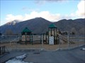 view gallery view galleryNW14 km |  Double Playground @ Hobble Creek Double Playground @ Hobble Creek
in Public Playgrounds There are two playgrounds across the parking lot from each other here at this elementary school, they are open to the public. posted by: JacobBarlow location: Utah date approved: 02/14/2007 last visited: 04/27/2011 |
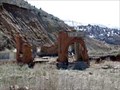
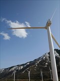 view gallery view galleryW14 km |  Spanish Fork Wind Farm Spanish Fork Wind Farm
in Windmills Wind Farm at the mouth of Spanish Fork Canyon. posted by: DrJay location: Utah date approved: 09/01/2008 last visited: 07/29/2021 |
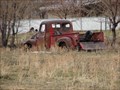 view gallery view galleryNW14.3 km |  The Neighbor's Dead Truck The Neighbor's Dead Truck
in Abandoned Dead Vehicles Just west of the home I grew up in, it is in a field, the coordinates are from the location I took the photo from. posted by: JacobBarlow location: Utah date approved: 02/11/2007 last visited: 08/23/2014 |
|