 view gallery view gallery SW14.5 km SW14.5 km
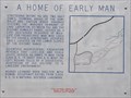
|   A Home of Early Man A Home of Early Man
in Nevada Historical Markers Nevada State Historical Marker No. 147 is located in the rest stop just south of Interstate Highway 80 on US Highway 95 posted by:  brwhiz brwhiz location: Nevada date approved: 09/11/2012 last visited: 03/10/2019 |
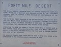 view gallery view gallerySW14.5 km | Forty Mile Desert in Nevada Historical Markers Nevada State Historical Marker No. 26 is located in the rest stop just south of Interstate Highway 80 on US Highway 95. posted by: brwhiz location: Nevada date approved: 09/11/2012 last visited: 11/06/2022 |
 view gallery view gallerySW14.5 km |  First Wagon Train to Cross Forty Mile Desert First Wagon Train to Cross Forty Mile Desert
in First of its Kind The Walker-Chiles party was the first to cross Forty Mile Desert on the California Trail. posted by: brwhiz location: Nevada date approved: 09/11/2012 last visited: 11/06/2022 |
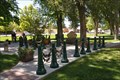
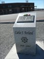 view gallery view gallerySW14.5 km |  Carlos Borland - Nevada Highway Patrol Trooper Carlos Borland - Nevada Highway Patrol Trooper
in Police Memorials This Police Memorial for Nevada Highway Patrol Trooper Carlos Borland is in the Fallon Rest Area on US 95 just south of I-80. posted by: PeterNoG location: Nevada date approved: 10/15/2016 last visited: 11/06/2022 |
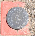
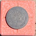
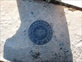
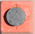 view gallery view gallerySW16.7 km |  NDOT 1158087K ~ US Highway 95 NDOT 1158087K ~ US Highway 95
in U.S. Benchmarks This Nevada Department of Transportation Right-of-Way marker is located on the east side of US 95 at Milepost CH57.16. posted by: brwhiz location: Nevada date approved: 09/13/2012 last visited: never |
 view gallery view gallery NE20.9 km NE20.9 km
|  Lovers Lock ~ Lovelock, Nevada Lovers Lock ~ Lovelock, Nevada
in Love Padlocks This Love Padlock is located in the park behind the historic Pershing County Courthouse at 400 Main Street in Lovelock, Nevada posted by: brwhiz location: Nevada date approved: 11/20/2012 last visited: 09/01/2018 |
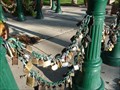 view gallery view galleryNE20.9 km |  Lovers Lock Plaza - Lovelock, NV Lovers Lock Plaza - Lovelock, NV
in Official Local Tourism Attractions Lovers Lock Plaza is located behind the historic Pershing County Courthouse. There you will find a circle of green metal pillars with linking chains and hundreds of attatched 'Lovers Locks'. posted by: find waldo location: Nevada date approved: 11/09/2010 last visited: 09/01/2018 |
 view gallery view galleryNE20.9 km |  Pershing County Courthouse - Lovelock, NV Pershing County Courthouse - Lovelock, NV
in Courthouses The Pershing County Courthouse is one of only two round courthouses in the nation. Tours of the inside are avaliable. posted by: find waldo location: Nevada date approved: 11/10/2010 last visited: 06/16/2019 |
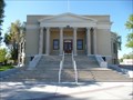 view gallery view galleryNE20.9 km |  Pershing County Courthouse - Lovelock, NV Pershing County Courthouse - Lovelock, NV
in U.S. National Register of Historic Places Located in the town of Lovelock along I-80 in Northern Nevada.
The Pershing County Courthouse sits in amongst large trees and picnic benches in the center of town. One of only two round courthouses in the nation.
Tours are avaliable. posted by: find waldo location: Nevada date approved: 11/12/2010 last visited: 06/16/2019 |
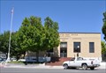 view gallery view galleryNE20.9 km |  Lovelock, Nevada 89419 Lovelock, Nevada 89419
in U.S. Post Offices This Post Office is located at 390 Main Street in Lovelock, Nevada. posted by: brwhiz location: Nevada date approved: 10/27/2011 last visited: 06/16/2019 |
 view gallery view galleryNE20.9 km |  McDonalds Free WiFi ~ Lovelock, Nevada McDonalds Free WiFi ~ Lovelock, Nevada
in Wi-Fi Hotspots Free WiFi Served Daily at the McDonalds at 1555 Main Street in Lovelock, Nevada. posted by: brwhiz location: Nevada date approved: 11/23/2012 last visited: 04/06/2017 |
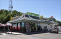
 view gallery view galleryNE20.9 km |  McDonalds ~ Lovelock, Nevada McDonalds ~ Lovelock, Nevada
in McDonald's Restaurants This McDonalds is located at 1555 Main Street in Lovelock, Nevada. posted by: brwhiz location: Nevada date approved: 12/01/2012 last visited: 04/06/2017 |
 view gallery view galleryNE21.6 km |  Sturgeons Motel & Casino ~ Lovelock, Nevada Sturgeons Motel & Casino ~ Lovelock, Nevada
in Casinos This small-town casino provides 24 hour-per-day action at 1420 Cornell Avenue in Lovelock, Nevada. posted by: brwhiz location: Nevada date approved: 09/19/2012 last visited: 04/06/2017 |
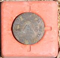 view gallery view gallerySW26.4 km | NDOT 1158068M ~ US Highway 95 in U.S. Benchmarks This Nevada Department of Transportation Right-of-Way marker is located on the east side of US 95 at Milepost CH50.68. posted by: brwhiz location: Nevada date approved: 09/13/2012 last visited: never |
 view gallery view gallery S38.9 km S38.9 km
| NDOT 1158043K ~ US Highway 95 in U.S. Benchmarks This Nevada Department of Transportation Right-of-Way marker is located on the east side of US 95 at Milepost CH42.05. posted by: brwhiz location: Nevada date approved: 09/13/2012 last visited: never |
 view gallery view galleryS40.1 km | NDOT 1158041K ~ US Highway 95 in U.S. Benchmarks This Nevada Department of Transportation Right-of-Way marker is located on the east side of US 95 at Milepost CH41.30. posted by: brwhiz location: Nevada date approved: 09/13/2012 last visited: never |
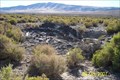 view gallery view gallerySW48.8 km |  Leete (Eagle Salt Works), Nevada Leete (Eagle Salt Works), Nevada
in Ghost Towns From 1871 through 1915, this town housed the mills and employees of Eagle Salt Works. posted by: Nitro929 location: Nevada date approved: 09/13/2007 last visited: 05/20/2012 |
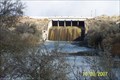 view gallery view galleryNE55.5 km |  Rye Patch Dam Rye Patch Dam
in Water Dams Located on the Humboldt River in Pershing County, Rye Patch Dam provides flood control & irrigation for the Lovelock basin. posted by: Nitro929 location: Nevada date approved: 10/22/2007 last visited: never |
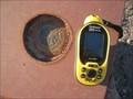 view gallery view galleryS61.3 km | Beacon Base; Muni Airport; Churchill County NV in U.S. Benchmarks Benchmark located in the concrete base of the light beacon at the Fallon Municipal Airport. posted by: Bobgetto location: Nevada date approved: 02/13/2012 last visited: never |
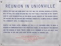 view gallery view galleryNE61.8 km | Reunion In Unionville in Nevada Historical Markers Nevada State Historical Marker No. 231 is located in Mohea Whitaker Memorial Youth Park of Unionville. posted by: brwhiz location: Nevada date approved: 09/11/2012 last visited: never |
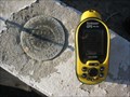 view gallery view galleryS61.8 km | N 390 Churchill County Nevada in U.S. Benchmarks This Benchmark in in the top of a concrete irrigation structure. Part of the Truckee Carson Irrigation System. posted by: Bobgetto location: Nevada date approved: 02/13/2012 last visited: 03/16/2012 |
 view gallery view galleryS62 km | USRS Benchmark Stillwater NV Ditchhouse Ln in U.S. Benchmarks Benchmark disc from the U.S. Reclamation Service. posted by: Bobgetto location: Nevada date approved: 02/09/2012 last visited: never |
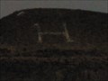 view gallery view gallerySW62.4 km |  H is for Hazen - Hazen, NV H is for Hazen - Hazen, NV
in Letters on Hills Hazen, Nevada is located along Highway 50 between Fernley and Fallon. posted by:  Chasing Blue Sky Chasing Blue Sky location: Nevada date approved: 02/14/2012 last visited: 10/06/2012 |
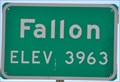 view gallery view galleryS62.8 km |  Fallon, Nevada (Northern Approach) ~ Elevation 3963 Feet Fallon, Nevada (Northern Approach) ~ Elevation 3963 Feet
in Elevation Signs This Elevation Sign is located on the west side of US Highway 95 at the northern city limit of Fallon, Nevada. posted by: brwhiz location: Nevada date approved: 02/10/2013 last visited: never |
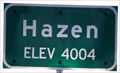 view gallery view gallerySW63.4 km | Hazen, Nevada (Southeastern Approach) ~ Elevation 4004 Feet in Elevation Signs Hazen is a small community along the highway between Fernley and Fallon, Nevada. posted by: brwhiz location: Nevada date approved: 06/03/2011 last visited: 09/28/2013 |
|