 view gallery view gallery E0.3 km E0.3 km
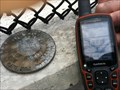
|   PENN DOT Survey Control Marker PENN DOT Survey Control Marker
in U.S. Benchmarks Survey Control Marker on a fairly new constructed bridge over railroad tracks - Rte 462 in Mountville, PA. The previous bridge here contained a benchmark KW0730 - that has probably been destroyed. posted by:  Lieblweb Lieblweb location: Pennsylvania date approved: 07/01/2012 last visited: never |
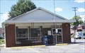 view gallery view galleryE0.3 km |  Mountville, Pennsylvania - 17554 Mountville, Pennsylvania - 17554
in U.S. Post Offices Mountville Post Office is located in Mountville Borough, Lancaster County, Pennsylvania.
posted by: deano1943 location: Pennsylvania date approved: 07/22/2007 last visited: 07/22/2007 |
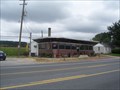 view gallery view gallery W2.6 km W2.6 km
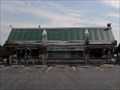
|  PROSPECT DINER - Columbia,Pa. PROSPECT DINER - Columbia,Pa.
in Independent Diners On Pa. st. Rt. 462 & a block west of Prospect Road exit of Pa. St. Rt. 30 & 1 mile west of Mountville,Pa. & 4 miles east of Columbia,Pa is a neat 1950's style diner;The Prospect. And Good Eats. posted by:  sclave sclave location: Pennsylvania date approved: 10/31/2009 last visited: 01/02/2015 |
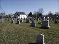 view gallery view gallery NE3.7 km NE3.7 km
|  Centerville Cemetery, East Hampfield Township, Lancaster County, Pennsylvania Centerville Cemetery, East Hampfield Township, Lancaster County, Pennsylvania
in Worldwide Cemeteries Centerville Cemetery is located in the small community of Centerville in East Hampfield Township, Lancaster County, Pennsylvania. posted by: deano1943 location: Pennsylvania date approved: 03/29/2010 last visited: 03/29/2010 |
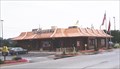 view gallery view galleryW3.9 km |  McDonald's, Columbia, Pennsylvania McDonald's, Columbia, Pennsylvania
in McDonald's Restaurants This McDonald's is located along Rt. 462, on Columbia Avenue, in Lancaster County, Pennsylvania. posted by: deano1943 location: Pennsylvania date approved: 09/04/2006 last visited: 03/23/2008 |
 view gallery view galleryW4.7 km | Lincoln Highway Diner - Columbia, PA in Independent Diners The prototypical diner may be found right here, on the historic Lincoln Highway. The place is reminiscent of a Jersey or Philly diner. posted by: Math Teacher location: Pennsylvania date approved: 08/08/2010 last visited: never |
 view gallery view galleryW4.8 km |  9/11 Remembrance @ Glatfelter Memorial Field - Columbia, PA 9/11 Remembrance @ Glatfelter Memorial Field - Columbia, PA
in 9/11 Memorial Sites A sturdy, metal sign on the right side of the road greets visitors to this 1937 Field. The sign explains the memorial and where to look for it. posted by: Math Teacher location: Pennsylvania date approved: 08/16/2010 last visited: never |
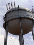
 view gallery view galleryW5 km | USMC Reserve Tank - Columbia, PA in U.S. Benchmarks Historic tower and benchmark overlooking Lincoln Highway? Not quite. Ironically enough, the water tower overlooks a liquor store. posted by: Math Teacher location: Pennsylvania date approved: 08/04/2010 last visited: 03/20/2013 |
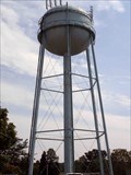
 view gallery view galleryW5 km |  Lincoln Highway Water Tower - Columbia, PA Lincoln Highway Water Tower - Columbia, PA
in Water Towers Historic tower overlooking Lincoln Highway? Not quite. Ironically enough, the water tower overlooks a liquor store. posted by: Math Teacher location: Pennsylvania date approved: 08/04/2010 last visited: 07/18/2008 |
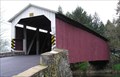 view gallery view gallery NW5.1 km NW5.1 km
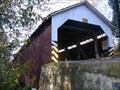
|  Forry's Mill Covered Bridge Forry's Mill Covered Bridge
in Covered Bridges This covered bridge is located on Bridge Valley Road in Lancaster County, Pennsylvania. posted by: deano1943 location: Pennsylvania date approved: 04/14/2006 last visited: 07/20/2019 |
 view gallery view galleryNW5.1 km |  Forry's Mill Covered Bridge Forry's Mill Covered Bridge
in U.S. National Register of Historic Places Forry's Mill Covered bridge is located on Bridge Valley Road, between Rapho and West Hempfield Township's, in Lancaster County, Pennsylvania. posted by: deano1943 location: Pennsylvania date approved: 08/28/2006 last visited: 11/07/2010 |
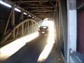
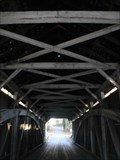
 view gallery view galleryNW5.1 km |  Forry's Mill Covered Bridge - West Hempfield Township, PA Forry's Mill Covered Bridge - West Hempfield Township, PA
in Wikipedia Entries As is typical of all Lancaster County bridges, this one too features a conventional double Burr arch trusses design with and the not often seen addition of steel hanger rods. posted by: Math Teacher location: Pennsylvania date approved: 11/10/2010 last visited: never |
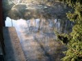 view gallery view galleryNW5.1 km | Little Chiques Creek - Lancaster County, PA in Wikipedia Entries Known by many variances on its original name, this beautiful, winding creek has gained it notoriety from being host to several 19th century covered bridges. This creek is a tributary of the larger Chickies or Chiques Creek. posted by: Math Teacher location: Pennsylvania date approved: 11/15/2010 last visited: 12/27/2014 |
 view gallery view galleryNW5.1 km |  Forry's Mill Covered Bridge - West Hempfield Township, PA Forry's Mill Covered Bridge - West Hempfield Township, PA
in Truss Bridges As is typical of all Lancaster County bridges, this one too features a conventional double Burr arch trusses design with and the not often seen addition of steel hanger rods. posted by: Math Teacher location: Pennsylvania date approved: 11/10/2010 last visited: never |
 view gallery view galleryNW5.1 km |  Little Chickies Creek - Lancaser County, PA Little Chickies Creek - Lancaser County, PA
in American Guide Series Known by many variances on its original name, this beautiful, winding creek has gained it notoriety from being host to several 19th century covered bridges. posted by: Math Teacher location: Pennsylvania date approved: 11/15/2010 last visited: 09/07/2015 |
 view gallery view galleryNW5.1 km |  Forry's Mill Covered Bridge - West Hempfield Township, PA Forry's Mill Covered Bridge - West Hempfield Township, PA
in Satellite Imagery Oddities As is typical of all Lancaster County bridges, this one too features a conventional double Burr arch trusses design with and the not often seen addition of steel hanger rods. posted by: Math Teacher location: Pennsylvania date approved: 08/11/2013 last visited: never |
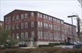
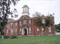 view gallery view galleryW5.3 km | Manor Street Elementary School in U.S. National Register of Historic Places Manor Street Elementary School is located at Tenth and Manor Street, in Columbia Borough, Lancaster County, Pennsylvania. posted by: deano1943 location: Pennsylvania date approved: 09/07/2006 last visited: 03/02/2008 |
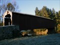
 view gallery view galleryNW5.5 km | Siegrist's Mill Covered Bridge - West Hempfield Township, PA in Wikipedia Entries As is typical of all Lancaster County bridges, this one too features a conventional double Burr arch trusses design with and the not often seen addition of steel hanger rods. Forry's Mill Covered, less than a mile away, is of similar construction. posted by: Math Teacher location: Pennsylvania date approved: 11/10/2010 last visited: 07/24/2018 |
 view gallery view galleryNW5.5 km | Siegrist's Mill Covered Bridge - West Hempfield Township, PA in Truss Bridges As is typical of all Lancaster County bridges, this one too features a conventional double Burr arch trusses design with and the not often seen addition of steel hanger rods. Forry's Mill Covered, less than a mile away, is of similar construction. posted by: Math Teacher location: Pennsylvania date approved: 11/10/2010 last visited: never |
 view gallery view galleryNW5.5 km | Seigrist's Mill Covered Bridge in U.S. National Register of Historic Places Seigrist's Mill Covered Bridge in on Seigrist Road
(T-360), in Rapho Township, Lancaster County, Pennsylvania. posted by: deano1943 location: Pennsylvania date approved: 08/28/2006 last visited: 04/16/2015 |
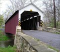 view gallery view galleryNW5.5 km | Seigrist's Mill Covered Bridge in Covered Bridges This covered bridge is located on Siegrist Road, in Rapho Township, Lancaster County, Pennsylvania. posted by: deano1943 location: Pennsylvania date approved: 04/14/2006 last visited: 07/20/2019 |
 view gallery view galleryW5.6 km | Columbia Wagon Works in U.S. National Register of Historic Places Columbia Wagon Works is located at 920 Plane Street, Columbia Borough, Lancaster County, Pennsylvania. posted by: deano1943 location: Pennsylvania date approved: 09/06/2006 last visited: 02/10/2008 |
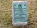 view gallery view galleryW5.8 km |  Lloyd Mifflin - Columbia, Pennsylvania, USA Lloyd Mifflin - Columbia, Pennsylvania, USA
in Dead Poets' Society Memorials The monument is located near the grave of Lloyd Mifflin. Located in the Mount Bethel Cemetery Columbia, Lancaster County, PA. posted by: ted28285 location: Pennsylvania date approved: 03/04/2024 last visited: 03/01/2024 |
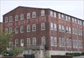 view gallery view galleryW5.8 km |  Columbia Wagon Work's, Columbia, Pennsylvania Columbia Wagon Work's, Columbia, Pennsylvania
in Ghost Signs This Ghost Sign is located to the rear of 920 Plane Street, Columbia Borough, Lancaster County, Pennsylvania. posted by: deano1943 location: Pennsylvania date approved: 09/04/2006 last visited: 02/10/2008 |
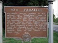 view gallery view gallery SW5.8 km SW5.8 km
|  N 40° 00.000 - Washington Boro, PA N 40° 00.000 - Washington Boro, PA
in Permanent Geographic Coordinates The title of this historic marker displays geographic coordinates in an unusual way, listing the perfect place to find zeroes, also known as the 40th parallel. The marker which tells the tale of the Mason-Dixon Line, revisiting old boundaries. posted by: Math Teacher location: Pennsylvania date approved: 09/16/2011 last visited: 06/02/2012 |
|