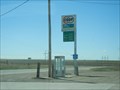
 view gallery view gallery N13.5 km N13.5 km
|   Yuma Country - Yuma, CO Yuma Country - Yuma, CO
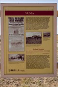
in Colorado Historical Markers A historical marker commemorating the Yuma Indian teamster who died somewhere along the Chicago, Burlington & Quincy Railroad tracks, giving name to the town and county of Yuma. posted by:  IJAdventures IJAdventures location: Colorado date approved: 10/04/2012 last visited: never |
 view gallery view galleryN13.5 km |  "Yuma" The Indian Railroad Hand - Yuma, CO "Yuma" The Indian Railroad Hand - Yuma, CO
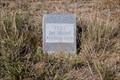
in Out of Place Graves A gravestone by the side of the highway recognizing the Yuma Indian teamster who died somewhere along the Chicago, Burlington & Quincy Railroad tracks, giving name to the town and county of Yuma. posted by: IJAdventures location: Colorado date approved: 10/06/2012 last visited: never |
 view gallery view galleryN13.5 km |  "You Are Here" at Yuma - Yuma, CO "You Are Here" at Yuma - Yuma, CO
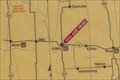
in 'You Are Here' Maps "You Are Here" sign at the Colorado Historical Society marker for the town and county of Yuma. posted by: IJAdventures location: Colorado date approved: 10/11/2012 last visited: never |
 view gallery view galleryN15 km |  George J. Shopp-Yuma, CO George J. Shopp-Yuma, CO
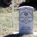
in Medal Of Honor Resting Places Civil War Medal of Honor Recipient for action at Five Forks, VA on April 1, 1865. He is buried in Yuma Cemetery, Yuma, CO. posted by:  Don.Morfe Don.Morfe location: Colorado date approved: 05/06/2019 last visited: 12/05/2021 |
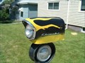 view gallery view gallery E40.9 km E40.9 km
|  Chevrolet Mailbox - Wray, Colorado Chevrolet Mailbox - Wray, Colorado
in Car Part Sculptures Mailbox made of various Chevrolet parts including headlight for the mailbox door. posted by:  BruceS BruceS location: Colorado date approved: 08/18/2007 last visited: never |
 view gallery view galleryE40.9 km |  Chevrolet Mailbox - Wray, Colorado Chevrolet Mailbox - Wray, Colorado
in Themed Homemade Mailboxes Mailbox made of various Chevrolet parts including headlight for the mailbox door. posted by: BruceS location: Colorado date approved: 08/19/2007 last visited: never |
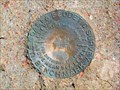 view gallery view gallery S45.4 km S45.4 km
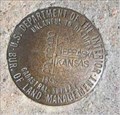
|  X 74 (KJ0159) - Washington County, Colorado X 74 (KJ0159) - Washington County, Colorado
in U.S. Benchmarks A benchmark disk in the northwest corner of the intersection of State Highway 59 and County Road 3. posted by: Tom.dog location: Colorado date approved: 11/17/2022 last visited: never |
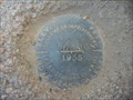 view gallery view gallery SW50.2 km SW50.2 km
| KJ0176 (L56) - Washington County, CO in U.S. Benchmarks KJ0176 (L56) Benchmark near Anton Colorado posted by: LT_Dream location: Colorado date approved: 03/29/2015 last visited: never |
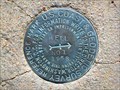
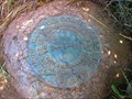
 view gallery view gallerySW53.3 km |  WASHKIT Azimuth Mark - Kit Carson County, Colorado WASHKIT Azimuth Mark - Kit Carson County, Colorado
in Azimuth Benchmarks The disturbed azimuth mark for triangulation station WASHKIT. posted by: Tom.dog location: Colorado date approved: 07/02/2023 last visited: never |
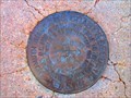 view gallery view gallerySW53.3 km | WASHKIT Azimuth Mark - Kit Carson County, Colorado in U.S. Benchmarks The disturbed azimuth mark for triangulation station WASHKIT. posted by: Tom.dog location: Colorado date approved: 11/17/2022 last visited: never |
 view gallery view gallerySW53.3 km |  Anton's Phone Booth Anton's Phone Booth
in Payphones Anton's Phone Booth posted by: LT_Dream location: Colorado date approved: 03/29/2015 last visited: never |
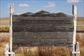 view gallery view galleryE53.9 km | Colorado: Entering the Centennial State - Laird, CO in Colorado Historical Markers This historical marker, located near the Colorado-Nebraska border off U.S. 34, gives a brief overview of the Centennial State. posted by: IJAdventures location: Colorado date approved: 10/11/2012 last visited: 04/21/2017 |
 view gallery view galleryE55 km |  Sixth Principle Meridian - Wray, CO Sixth Principle Meridian - Wray, CO
in Great Lines of Earth This marker commemorates the various surveys that were done in the 19th century near the corner point of of Kansas, Nebraska, and Colorado. Some of those surveys related to the 6th Principle Meridian which marks the border between Kansas & Nebraska. posted by: onfire4jesus location: Colorado date approved: 04/15/2014 last visited: 10/26/2021 |
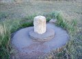 view gallery view galleryE55 km |  Chaffees Corner - NW Corner Border of Kansas Chaffees Corner - NW Corner Border of Kansas
in U.S. Historic Survey Stones and Monuments This carved pillar of Limestone marks the north west corner of Kansas. Actually it marks a location 615 feet south of the actual plotted corner as replotted in 1993. posted by: condor1 location: Kansas date approved: 07/11/2009 last visited: 05/08/2021 |
 view gallery view galleryE55 km |  3 Corners Boundary Marker - KS / CO / NE 3 Corners Boundary Marker - KS / CO / NE
in Tripoints and Multipoints The Tri-Point is identified by the 3-Corners Benchmark and is located at the junction of the borders of Colorado, Kansas and Nebraska. posted by: condor1 location: Colorado date approved: 04/11/2012 last visited: 10/26/2021 |
 view gallery view galleryE55 km | 3 Corners Boundry Marker - KS / CO / NE in U.S. Benchmarks The 3-Corners Benchmark is located at the junction of the borders of Colorado, Kansas and Nebraska. posted by: condor1 location: Kansas date approved: 07/12/2009 last visited: 10/26/2021 |
 view gallery view galleryS55 km | HELL NO 1 - Kit Carson County, Colorado in U.S. Benchmarks Reference mark 1 for triangulation station HELL. posted by: Tom.dog location: Colorado date approved: 11/17/2022 last visited: never |
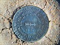 view gallery view galleryS55 km | HELL NO 2 - Kit Carson County, Colorado in U.S. Benchmarks Reference mark 2 for triangulation station HELL. posted by: Tom.dog location: Colorado date approved: 11/17/2022 last visited: never |
 view gallery view galleryS55 km | HELL (KJ0469) - Kit Carson County, Colorado in U.S. Benchmarks A triangulation station on the north side of LL Road, about 1 mile east of State Highway 59. posted by: Tom.dog location: Colorado date approved: 11/17/2022 last visited: never |
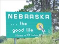 view gallery view galleryE55.5 km |  Colorado / Nebraska Border - Highway 34, Nebraska Colorado / Nebraska Border - Highway 34, Nebraska
in Border Crossings a border crossing between the US states of Colorado and Nebraska located on highway 34 in Nebraska, USA. posted by: oiseau_ca location: Nebraska date approved: 09/20/2015 last visited: never |
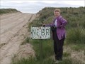 view gallery view galleryE57.8 km | Nebraska-Kansas - backroad sign in Border Crossings Nebraska-Kansas border on a county road. posted by: NevaP location: Nebraska date approved: 08/16/2005 last visited: 05/21/2021 |
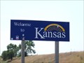 view gallery view galleryE65.2 km | Nebraska / Kansas Border - Highway 27, Kansas in Border Crossings a border crossing between the US states of Nebraska and Kansas located on highway 27 in Kansas, USA. posted by: oiseau_ca location: Kansas date approved: 09/20/2015 last visited: 04/28/2015 |
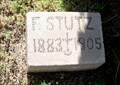 view gallery view galleryS66.5 km |  F. Stutz's Homemade Tombstone, Bethune, CO F. Stutz's Homemade Tombstone, Bethune, CO
in Homemade Tombstones Found among a number of homemade markers in a rural church cemetery posted by: ronjean location: Colorado date approved: 06/29/2010 last visited: never |
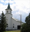 view gallery view galleryS66.6 km |  Immanuel Lutheran Church, Bethune, CO Immanuel Lutheran Church, Bethune, CO
in Country Churches Immanuel is the first American Lutheran Church in Colorado, founded in 1890 posted by: ronjean location: Colorado date approved: 06/30/2010 last visited: 06/02/2015 |
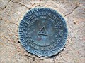
 view gallery view galleryS66.6 km | BOREN Azimuth Mark - Kit Carson County, Colorado in U.S. Benchmarks Azimuth mark for triangulation station BOREN. posted by: Tom.dog location: Colorado date approved: 11/17/2022 last visited: never |
|