 view gallery view gallery N2.6 km N2.6 km
|   Highway 83, South Nebraska Highway 83, South Nebraska
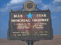
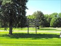
in Blue Star Memorial Highway Markers Blue Star Highway sign on Highway 83 in Southern Nebraska posted by:  Prying Pandora Prying Pandora location: Nebraska date approved: 05/27/2007 last visited: 05/07/2012 |
 view gallery view gallery S17.5 km S17.5 km
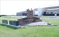
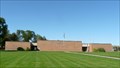
|  Oberlin Municipal Airport - Oberlin, KS Oberlin Municipal Airport - Oberlin, KS
in Airports Oberlin Municipal Airport is located in the city of Oberlin, Kansas. posted by: oiseau_ca location: Kansas date approved: 01/15/2016 last visited: never |
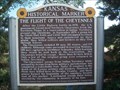 view gallery view galleryS18.5 km |  The Flight of the Cheyennes The Flight of the Cheyennes
in Kansas Historical Markers Historical marker about the escape and flight of a group of Cheyennes from a reservation to their homeland. posted by: Prying Pandora location: Kansas date approved: 05/23/2007 last visited: 05/07/2021 |
 view gallery view galleryN23.5 km |  Karrer Park - McCook, NE Karrer Park - McCook, NE
in Free Campsites Karrer Park is a city park in McCook, NE with 7 RV spots and plenty of room for primitive camping that are free and are available on a first come/first serve basis. posted by:  onfire4jesus onfire4jesus location: Nebraska date approved: 08/25/2013 last visited: 08/25/2013 |
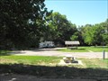 view gallery view galleryN23.5 km | Karrer Park - McCook, NE in Campgrounds Karrer Park is a city park in McCook, NE with 7 RV spots and plenty of room for primitive camping that are free and are available on a first come/first serve basis. posted by: onfire4jesus location: Nebraska date approved: 08/25/2013 last visited: 06/28/2013 |
 view gallery view galleryN23.5 km |  McCook, NE Karrer Park McCook, NE Karrer Park
in Free Overnight RV Parking Locations Karrer Park is a city park in McCook, NE with 7 RV spots that are free and are available on a first come/first serve basis. posted by: onfire4jesus location: Nebraska date approved: 07/07/2013 last visited: 06/28/2013 |
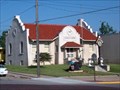 view gallery view galleryN24.1 km |  Carnegie Library, McCook, NE Carnegie Library, McCook, NE
in Carnegie Library Buildings Carnegie Library in McCook, Nebraska posted by: Prying Pandora location: Nebraska date approved: 05/23/2007 last visited: 03/13/2011 |
 view gallery view galleryN24.1 km |  Red Willow County Courthouse, McCook NE Red Willow County Courthouse, McCook NE
in Courthouses Red Willow County's Current Courthouse as served the county since 1927. posted by:  NevaP NevaP location: Nebraska date approved: 10/12/2008 last visited: 03/13/2011 |
 view gallery view galleryN24.1 km |  Red Willow County Courthouse - McCook, NE Red Willow County Courthouse - McCook, NE
in U.S. National Register of Historic Places This classical Revival Style courthouse was built in 1926. posted by: NevaP location: Nebraska date approved: 06/09/2009 last visited: 03/13/2011 |
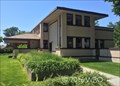 view gallery view galleryN24.3 km |  Harvey and Elizabeth Sutton House Harvey and Elizabeth Sutton House
in Frank Lloyd Wright Designed Buildings Only Frank Lloyd Wright house in the Cornhusker State... posted by: Darmok and Jalad location: Nebraska date approved: 08/24/2016 last visited: never |
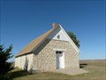 view gallery view gallery NW24.9 km NW24.9 km
| St. Paul's Methodist Protestant Church Also known as The Stone Church in U.S. National Register of Historic Places This stone church was built in 1900 and used for services until 1951. posted by: NevaP location: Nebraska date approved: 10/06/2008 last visited: never |
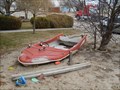 view gallery view galleryN25.4 km |  Boat Sandbox, McCook, NE Boat Sandbox, McCook, NE
in Landlocked Boats A creative use of an older boat. It is a sand box in the yard. posted by: lyonden_ut location: Nebraska date approved: 03/13/2011 last visited: never |
 view gallery view gallery NE30.3 km NE30.3 km
|  Pawnee Squaw - Indianola, NE Pawnee Squaw - Indianola, NE
in Graves Mentioning a Cause of Death The grave of a Pawnee Squaw whose name is unknown is located in the town park in Indianola, Nebraska, USA. She was killed by Indian arrows in 1873. posted by: Marine Biologist location: Nebraska date approved: 04/23/2015 last visited: never |
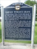 view gallery view galleryNE30.3 km |  Pawnee Woman's Grave - Indianola, NE Pawnee Woman's Grave - Indianola, NE
in Nebraska Historical Markers This historical marker about a Pawnee Woman's Grave is located in Indianola City Park in Indianola, Nebraska. posted by: Marine Biologist location: Nebraska date approved: 08/16/2011 last visited: never |
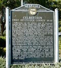 view gallery view galleryNW35.4 km | Culbertson - First Hitchcock County Seat in Nebraska Historical Markers This marker is in a small park in Culbertson. posted by: NevaP location: Nebraska date approved: 10/05/2008 last visited: 05/08/2012 |
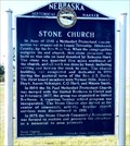 view gallery view galleryNW36.2 km | Stone Church in Nebraska Historical Markers A historic stone church is preserved at this site. posted by: NevaP location: Nebraska date approved: 10/05/2008 last visited: never |
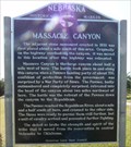 view gallery view galleryNW41.2 km | Massacre Canyon in Nebraska Historical Markers The marker stands near the site of the 1873 final battle between Pawnee and Sioux tribes in Nebraska. posted by: NevaP location: Nebraska date approved: 10/05/2008 last visited: 05/08/2012 |
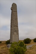 view gallery view galleryNW41.4 km |  Massacre Canyon Battlefield Memorial - Trenton, NE Massacre Canyon Battlefield Memorial - Trenton, NE
in Obelisks A monument erected in 1930 to commemorate the Massacre Canyon Battle between the Pawnee and the Sioux. The monument stands 35 feet tall and weighs over 90 tons. posted by: IJAdventures location: Nebraska date approved: 10/12/2012 last visited: 05/08/2012 |
 view gallery view galleryNW41.4 km |  Buffalo Hunt at Massacre Canyon Battlefield Memorial - Trenton, NE Buffalo Hunt at Massacre Canyon Battlefield Memorial - Trenton, NE
in Silhouette Public Art Sculptures A wooden silhouette depicting an Indian on horseback chasing a buffalo at the site of the Massacre Canyon Battlefield. posted by: IJAdventures location: Nebraska date approved: 10/12/2012 last visited: never |
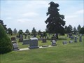 view gallery view galleryS41.8 km |  Dresden Cemetery - Dresden, KS Dresden Cemetery - Dresden, KS
in Worldwide Cemeteries Located in a small Northwestern town in Kansas. posted by: mr.volkswagen location: Kansas date approved: 07/18/2007 last visited: never |
 view gallery view galleryNW42.6 km | Hitchcock County Courthouse, Trenton, Nebraska in Courthouses This brick courthouse was built in 1969 posted by: NevaP location: Nebraska date approved: 10/18/2008 last visited: never |
 view gallery view gallery SW44.4 km SW44.4 km
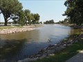
|  Atwood Lake-Through the Looking Glass - Atwood, Kansas, USA Atwood Lake-Through the Looking Glass - Atwood, Kansas, USA
in Natural Lakes This waymark is for Atwood Lake in Atwood, Kansas. posted by: OceanicCrew815 location: Kansas date approved: 08/16/2018 last visited: 08/06/2020 |
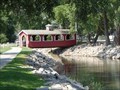 view gallery view gallerySW44.6 km |  Atwood Lake Covered Bridge- Lost Series of Waymarks Atwood Lake Covered Bridge- Lost Series of Waymarks
in Covered Bridges This is a covered bridge that is located at the Atwood Lake. posted by: OceanicCrew815 location: Kansas date approved: 08/16/2018 last visited: 08/06/2020 |
 view gallery view gallerySW44.6 km |  Buffalo - Atwood, Kansas Buffalo - Atwood, Kansas
in School Mascots The Atwood Buffalo is the mascot for the Rawlins County High School sports teams - in Atwood, Kansas. posted by: The Snowdog location: Kansas date approved: 01/08/2021 last visited: never |
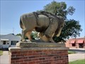 view gallery view gallerySW44.6 km |  Atwood Buffalo - Atwood, KS Atwood Buffalo - Atwood, KS
in Figurative Public Sculpture The Atwood Buffalo stands watch from the median of Main Street near the Rawlins County Courthouse in Atwood, Kansas. posted by: The Snowdog location: Kansas date approved: 01/09/2021 last visited: never |
|