 view gallery view gallery SE20.9 km SE20.9 km
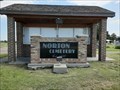
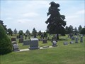
|   Norton Cemetery - Norton, KS Norton Cemetery - Norton, KS
in Worldwide Cemeteries This large cemetery is on the north side of Norton, Kansas. posted by:  The Snowdog The Snowdog location: Kansas date approved: 01/09/2021 last visited: never |
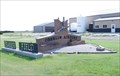
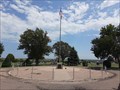 view gallery view gallerySE21.1 km |  Norton Veterans Memorial - Norton, KS Norton Veterans Memorial - Norton, KS
in Non-Specific Veteran Memorials This veterans memorial is the centerpiece of Norton Cemetery, on the northwest side of Norton, Kansas. posted by: The Snowdog location: Kansas date approved: 01/09/2021 last visited: never |
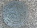
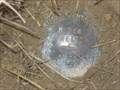
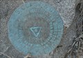 view gallery view gallerySE21.1 km |  KG0518: NORTON - Norton KS KG0518: NORTON - Norton KS
in U.S. Benchmarks This Benchmark is just west of the Water Tower on Warsaw Street and Jones Avenue in Norton, Kansas. posted by: PeterNoG location: Kansas date approved: 09/29/2013 last visited: 03/07/2022 |
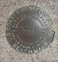
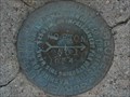 view gallery view gallerySE21.2 km | KG0518: NORTON RM1 - Norton KS in U.S. Benchmarks This Benchmark is 60 feet northwest of the Water Tower on Warsaw Street and Jones Avenue in Norton, Kansas. posted by: PeterNoG location: Kansas date approved: 12/24/2013 last visited: 08/06/2020 |
 view gallery view gallerySE21.2 km | KG0827: Norton Municipal Tank - Norton KS in U.S. Benchmarks This Benchmark is the Water Tower on Warsaw Street and Jones Avenue in Norton, Kansas. posted by: PeterNoG location: Kansas date approved: 09/29/2013 last visited: 03/07/2022 |
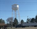 view gallery view gallerySE21.2 km |  Water Tower - Norton KS Water Tower - Norton KS
in Water Towers This Water Tower is at Warsaw Street and Jones Avenue in Norton, Kansas. posted by: PeterNoG location: Kansas date approved: 10/01/2013 last visited: 03/07/2022 |
 view gallery view gallerySE21.2 km | KG0518: NORTON RM2 - Norton KS in U.S. Benchmarks This Benchmark is 60 feet southwest of the Water Tower on Warsaw Street and Jones Avenue in Norton, Kansas. posted by: PeterNoG location: Kansas date approved: 12/24/2013 last visited: 08/06/2020 |
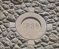
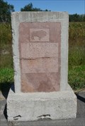
 view gallery view gallerySE22.2 km | NORTON 1933 - Norton, KS in U.S. Benchmarks This U.S. Coast and Geodetic Survey benchmark disk is near the old Norton Public Library; in Norton, Kansas. posted by: The Snowdog location: Kansas date approved: 01/08/2021 last visited: 03/07/2022 |
 view gallery view gallerySE22.2 km |  1938 - Norton Public Library, Norton, KS 1938 - Norton Public Library, Norton, KS
in Dated Buildings and Cornerstones The Norton Public Library building was constructed in 1938 - in Norton, Kansas. posted by: The Snowdog location: Kansas date approved: 01/07/2021 last visited: never |
 view gallery view gallerySE22.2 km |  Norton County Historical Museum - Norton, KS Norton County Historical Museum - Norton, KS
in History Museums The Norton County Historical Museum is housed in the old Norton Public Library in Norton, Kansas. posted by: The Snowdog location: Kansas date approved: 01/07/2021 last visited: never |
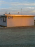 view gallery view gallerySE23.5 km |  KQNK FM 106.7 & AM 1530 KQNK FM 106.7 & AM 1530
in A.M./F.M. Radio Broadcasting Stations This is Norton's local radio station. It plays "Classic Rock" and it's highlight is "The Party Line" every week-day starting at 9:00a. posted by:  gpboutwell gpboutwell location: Kansas date approved: 03/06/2009 last visited: never |
 view gallery view gallery NE26.4 km NE26.4 km
|  Furnas County Courthouse, Beaver City, Nebraksa Furnas County Courthouse, Beaver City, Nebraksa
in Courthouses This 1951 courthouse is the second to serve the county posted by:  NevaP NevaP location: Nebraska date approved: 09/30/2008 last visited: never |
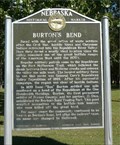
 view gallery view galleryNE27.5 km |  Nebraska's Flying Doctor Nebraska's Flying Doctor
in Nebraska Historical Markers This marker is about a pioneer of aviation use by a medical practice. posted by: NevaP location: Nebraska date approved: 10/03/2008 last visited: never |
 view gallery view gallerySE31.9 km | NGS M 364 RESET 1998, Kansas in U.S. Benchmarks NGS M 364 RESET 1998, KS, is a Vertical Control Mark located about 0.1 miles south of the intersection of US Highway 283 and Road T about eight miles south of Norton, Norton County, KS. posted by: seventhings location: Kansas date approved: 05/31/2006 last visited: never |
 view gallery view gallery N36.5 km N36.5 km
| Fort McPherson Trail in Nebraska Historical Markers This stone marker,located along Rt. 6, is on the route of the Fort McPherson Trail. posted by: NevaP location: Nebraska date approved: 09/30/2008 last visited: 12/23/2015 |
 view gallery view galleryN36.5 km | Burton's Bend in Nebraska Historical Markers The marker is about an early trading post on a bend of the Republican River near present day Holbrook posted by: NevaP location: Nebraska date approved: 09/30/2008 last visited: 08/10/2011 |
 view gallery view gallery NW41.8 km NW41.8 km
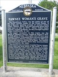
| Pawnee Woman's Grave - Indianola, NE in Nebraska Historical Markers This historical marker about a Pawnee Woman's Grave is located in Indianola City Park in Indianola, Nebraska. posted by: Marine Biologist location: Nebraska date approved: 08/16/2011 last visited: never |
 view gallery view galleryNW41.8 km |  Pawnee Squaw - Indianola, NE Pawnee Squaw - Indianola, NE
in Graves Mentioning a Cause of Death The grave of a Pawnee Squaw whose name is unknown is located in the town park in Indianola, Nebraska, USA. She was killed by Indian arrows in 1873. posted by: Marine Biologist location: Nebraska date approved: 04/23/2015 last visited: never |
 view gallery view gallery SW42.5 km SW42.5 km
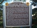
|  The Flight of the Cheyennes The Flight of the Cheyennes
in Kansas Historical Markers Historical marker about the escape and flight of a group of Cheyennes from a reservation to their homeland. posted by: Prying Pandora location: Kansas date approved: 05/23/2007 last visited: 05/07/2021 |
 view gallery view gallery S42.8 km S42.8 km
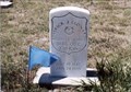
|  Patrick J. Leonard-New Almelo, KS Patrick J. Leonard-New Almelo, KS
in Medal Of Honor Resting Places Indian Campaigns Medal of Honor Recipient for action at Little Blue NE on May 15, 1870. He is buried in Saint Joseph Cemetery, New Almelo, KS in Section D posted by: Don.Morfe location: Kansas date approved: 05/21/2018 last visited: 12/13/2021 |
 view gallery view gallery W43.8 km W43.8 km
|  Oberlin Municipal Airport - Oberlin, KS Oberlin Municipal Airport - Oberlin, KS
in Airports Oberlin Municipal Airport is located in the city of Oberlin, Kansas. posted by: oiseau_ca location: Kansas date approved: 01/15/2016 last visited: never |
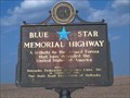 view gallery view galleryW43.8 km |  Highway 83, South Nebraska Highway 83, South Nebraska
in Blue Star Memorial Highway Markers Blue Star Highway sign on Highway 83 in Southern Nebraska posted by: Prying Pandora location: Nebraska date approved: 05/27/2007 last visited: 05/07/2012 |
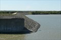 view gallery view galleryN46.3 km |  Medicine Creek Dam, Frontier County Nebraska Medicine Creek Dam, Frontier County Nebraska
in Water Dams This Bureau of Reclamation dam is located in the high plains region of southwestern Nebraska. posted by: NevaP location: Nebraska date approved: 10/07/2008 last visited: never |
 view gallery view gallerySW49.9 km | Dresden Cemetery - Dresden, KS in Worldwide Cemeteries Located in a small Northwestern town in Kansas. posted by: mr.volkswagen location: Kansas date approved: 07/18/2007 last visited: never |
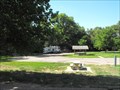 view gallery view galleryNW52.1 km |  Karrer Park - McCook, NE Karrer Park - McCook, NE
in Free Campsites Karrer Park is a city park in McCook, NE with 7 RV spots and plenty of room for primitive camping that are free and are available on a first come/first serve basis. posted by: onfire4jesus location: Nebraska date approved: 08/25/2013 last visited: 08/25/2013 |
|