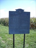
 view gallery view gallery E5.3 km E5.3 km
|   Pontiac Peace Treaty Pontiac Peace Treaty
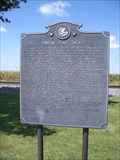
in Illinois Historical Markers Located on the west side of IL 1, 2.4 miles north of Chrisman posted by:  Stunod Stunod location: Illinois date approved: 09/05/2006 last visited: 11/05/2018 |
 view gallery view gallery NE6.6 km NE6.6 km
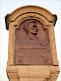
| Abraham Lincoln - Eighth Judicial District County (Vermilion / Edgar Counties) Line Marker - Ridge Farm, IL in Illinois Historical Markers The "border marker" for Vermilion and Edgar Counties along the Eighth Judicial District Circuit route that Lincoln traveled with his fellow lawyers to conduct legal duties. posted by:  adgorn adgorn location: Illinois date approved: 09/01/2014 last visited: never |
 view gallery view galleryNE6.6 km |  Abraham Lincoln - Eighth Judicial District County (Vermilion / Edgar Counties) Line Marker - Ridge Farm, IL Abraham Lincoln - Eighth Judicial District County (Vermilion / Edgar Counties) Line Marker - Ridge Farm, IL
in Abraham Lincoln The "border marker" for Vermilion and Edgar Counties along the Eighth Judicial District Circuit route that Lincoln traveled with his fellow lawyers to conduct legal duties. posted by: adgorn location: Illinois date approved: 09/01/2014 last visited: 05/28/2016 |
 view gallery view gallery SE7.7 km SE7.7 km
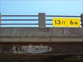
|  New York Central Railroad overpass - 1938 - Chrisman, IL New York Central Railroad overpass - 1938 - Chrisman, IL
in Bridge Date Stones and Plaques New York Central built this bridge in 1938 over US Highway 36. posted by: cldisme location: Illinois date approved: 07/19/2011 last visited: never |
 view gallery view gallery N9.5 km N9.5 km
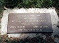
|  Ernest Calvin Williams-Indianola, IL Ernest Calvin Williams-Indianola, IL
in Medal Of Honor Resting Places Dominican Campaign Medal of Honor Recipient for action at San Francisco de Macoris, Dominican Republic on November 29, 1916. He is buried in Woodlawn Cemetery, Indianola, IL in Section 5, Lot 2. posted by:  Don.Morfe Don.Morfe location: Illinois date approved: 03/22/2018 last visited: 12/15/2021 |
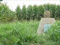
 view gallery view gallery S10.3 km S10.3 km
| Vincennes Trail Milestone # 97 - near Chrisman, IL in Illinois Historical Markers Small remnant of milestone marker preserved on concrete base with plaque. posted by: adgorn location: Illinois date approved: 08/18/2010 last visited: 06/15/2013 |
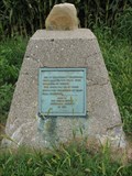 view gallery view galleryS10.3 km |  Vincennes Trail Milestone # 97 - near Chrisman, IL Vincennes Trail Milestone # 97 - near Chrisman, IL
in Milestones Small remnant of milestone marker preserved on concrete base with plaque. posted by: adgorn location: Illinois date approved: 08/18/2010 last visited: 06/15/2013 |
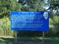 view gallery view gallerySE16.1 km | Thy Wondrous Story, Illinois in Illinois Historical Markers Located on the north side of US 36, just west of Indiana State line. posted by: Stunod location: Illinois date approved: 09/05/2006 last visited: 11/05/2018 |
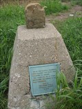 view gallery view galleryS16.6 km | Vincennes Trail Milestone # 93 - near Chrisman, IL in Illinois Historical Markers Small remnant of milestone marker preserved on concrete base with plaque. posted by: adgorn location: Illinois date approved: 08/18/2010 last visited: 07/16/2016 |
 view gallery view galleryS16.6 km | Vincennes Trail Milestone # 93 - near Chrisman, IL in Milestones Small remnant of milestone marker preserved on concrete base with plaque. posted by: adgorn location: Illinois date approved: 08/18/2010 last visited: 07/16/2016 |
 view gallery view galleryN17.5 km |  McCormick Blvd McDonalds - Skokie Illinois McCormick Blvd McDonalds - Skokie Illinois
in McDonald's Restaurants McDonalds located at McCormick and Touhy in Skokie, Illionois posted by: CHI-TOWN ROMEO location: Illinois date approved: 12/01/2012 last visited: 12/20/2012 |
 view gallery view gallery W18.2 km W18.2 km
| Pontiac's Conspiracy in Illinois Historical Markers Located on the south-east corner of Illinois Route 49 & Palermo Rd. posted by: Stunod location: Illinois date approved: 09/05/2006 last visited: 11/12/2017 |
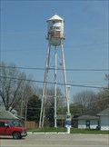 view gallery view galleryN18.5 km |  St Anne, IL St Anne, IL
in Water Towers Nice old tank. Was torn down Oct 13, 2008. Added pic of replacement tower. posted by: Team Fawlty location: Illinois date approved: 10/25/2008 last visited: never |
 view gallery view galleryN21.9 km |  C&EI 507 Caboose - Westville, IL C&EI 507 Caboose - Westville, IL
in Train Cabooses Chicago & Eastern Illinois 507 wood, bay window, built from boxcar 12/43, Station, Historical Society, Rt 1, from Cayuga, Indiana. Standing near the passenger depot originally built by the C&EI, now used as a museum. posted by: adgorn location: Illinois date approved: 06/07/2010 last visited: never |
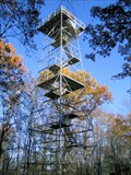 view gallery view galleryNE23 km |  Forest Glen Observation Tower Forest Glen Observation Tower
in Look-Out Towers The Forest Glen Preserve, a park in Vermillion County, IL, boasts a 72' observation tower. The tower provides a great view of the Vermillion River bottoms. posted by: NoLemon location: Illinois date approved: 10/30/2006 last visited: 06/10/2007 |
 view gallery view galleryN23.8 km | Potawatomi - A Trail of Death marker - Catlin, IL in Illinois Historical Markers Plaque on a stone next to the Catlin Heritage Museum, commemorating the Sandusky Point Encampment of the Potawatomi Trail of Death. posted by: adgorn location: Illinois date approved: 11/22/2011 last visited: never |
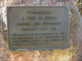 view gallery view galleryN23.8 km |  Potawatomi - A Trail of Death marker - Catlin, IL Potawatomi - A Trail of Death marker - Catlin, IL
in Trail of Tears Plaque on a stone next to the Catlin Heritage Museum, commemorating the Sandusky Point Encampment of the Potawatomi Trail of Death. posted by: adgorn location: Illinois date approved: 11/22/2011 last visited: never |
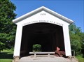 view gallery view galleryE24 km |  Hillsdale/Possum Bottom/Jackson's Ford Covered Bridge Hillsdale/Possum Bottom/Jackson's Ford Covered Bridge
in Orphaned Bridges This Covered Bridge has been relocated from its original site and now is located in the Ernie Pyle Rest Park on the north side of US Highway 36 about 4.5 miles west of Montezuma, Indiana. This bridge is on the National Register of Historic Places. posted by: brwhiz location: Indiana date approved: 07/16/2013 last visited: 10/29/2021 |
 view gallery view galleryE24 km |  Hillsdale/Possum Bottom/Jackson's Ford Covered Bridge Hillsdale/Possum Bottom/Jackson's Ford Covered Bridge
in Covered Bridges This Covered Bridge has been relocated from its original site and now is located in the Ernie Pyle Rest Park on the north side of US Highway 36 about 4.5 miles west of Montezuma, Indiana. This bridge is on the National Register of Historic Places. posted by: brwhiz location: Indiana date approved: 07/17/2013 last visited: 10/29/2021 |
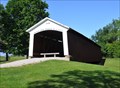
 view gallery view galleryE24 km |  Possom Bottom Covered Bridge ~ Dana, Indiana Possom Bottom Covered Bridge ~ Dana, Indiana
in U.S. National Register of Historic Places The Possom Bottom/Jackson's Ford/Hillsdale Covered Bridge was placed on the National Register of Historic Places on June 10, 1994 (#94000584). posted by: brwhiz location: Indiana date approved: 07/14/2013 last visited: 10/29/2021 |
 view gallery view galleryE24.1 km |  Ernie Pyle Rest Park Ernie Pyle Rest Park
in Highway Rest Areas This Highway Rest Area is located on the north side of US Highway 36 about 2.2 miles east of Dana, Indiana. posted by: brwhiz location: Indiana date approved: 07/14/2013 last visited: 10/29/2021 |
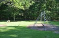 view gallery view galleryE24.1 km |  Ernie Pyle Rest Park Playground Ernie Pyle Rest Park Playground
in Public Playgrounds This Public Playground is located in the Ernie Pyle Rest Park on the north side of US Highway 36 about 4.5 miles west of Montezuma, Indiana. posted by: brwhiz location: Indiana date approved: 07/14/2013 last visited: 10/29/2021 |
 view gallery view galleryS24.3 km | Paris, Illinois in Illinois Historical Markers Located on the west side of Illinois Route 1 in Kiwanis Park in Paris Illinois posted by: Stunod location: Illinois date approved: 09/05/2006 last visited: 07/10/2016 |
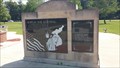 view gallery view galleryS24.3 km |  Korean War Memorial - Kiwanis Memorial Park, Paris, Illinois Korean War Memorial - Kiwanis Memorial Park, Paris, Illinois
in Korean War Memorials Memorial to Edgar County natives whose lives were lost in the Korean War posted by: switzr1 location: Illinois date approved: 07/12/2016 last visited: never |
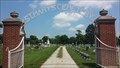 view gallery view galleryS24.8 km |  St. Mary's Cemetery, Paris, Illinois, USA St. Mary's Cemetery, Paris, Illinois, USA
in Worldwide Cemeteries St. Mary's Catholic Cemetery, by Twin Lakes in Paris, Illinois posted by: switzr1 location: Illinois date approved: 07/15/2016 last visited: never |
|