 view gallery view gallery W10 km W10 km
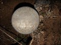
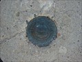
|   Kimball Benchmark Kimball Benchmark
in U.S. Benchmarks While looking for GCNCWR I ran across this Benchmark. posted by:  JacobBarlow JacobBarlow location: Utah date approved: 03/15/2007 last visited: 03/12/2011 |
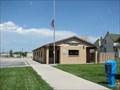
 view gallery view galleryW10 km |  Silver City Rest Area Silver City Rest Area
in Highway Rest Areas This simple rest area is located near the old mining ghost town of Silver City. posted by: brwhiz location: Utah date approved: 09/13/2013 last visited: never |
 view gallery view gallery E14 km E14 km
| USCGS KN0324 ~ L 55 in U.S. Benchmarks This US Benchmark is located on the west side of The Moana Road south of Santaquin, Utah. posted by: brwhiz location: Utah date approved: 09/09/2013 last visited: 02/22/2019 |
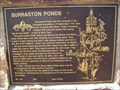
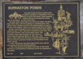 view gallery view galleryE14 km |  Burraston Ponds ~ 434 Burraston Ponds ~ 434
in D.U.P. Historic Markers This area was once a large cattle operation for the LDS Church. posted by: brwhiz location: Utah date approved: 04/08/2011 last visited: 06/17/2015 |
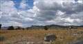
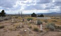
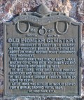
 view gallery view galleryE14 km |  Burraston Ponds Burraston Ponds
in Utah Historical Markers Burraston Ponds was the campsite of the Escalante Expedition, 27 September 1776, from Santa Fe to the Utah Basin. Father Escalante mapped this area and named this spring "Ojo de San Pablo" or Eye of Saint Paul.... posted by: JacobBarlow location: Utah date approved: 09/11/2007 last visited: 06/17/2015 |
 view gallery view gallery NW14.2 km NW14.2 km
|  The End of Silver City The End of Silver City
in Abandoned Cemeteries Silver City Utah, once a mining community, now a ghost town. posted by: JacobBarlow location: Utah date approved: 04/08/2007 last visited: 02/19/2011 |
 view gallery view galleryNW14.2 km |  Silver City, Utah Silver City, Utah
in Ghost Towns Silver City, Utah posted by: JacobBarlow location: Utah date approved: 04/08/2007 last visited: 03/25/2016 |
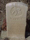
 view gallery view galleryNW14.2 km |  Silver City Cemetery Silver City Cemetery
in Worldwide Cemeteries This Cemetery served what is now the ghost town of Silver City in the Tintic Mining District. posted by: brwhiz location: Utah date approved: 09/10/2013 last visited: 03/25/2016 |
 view gallery view galleryE14.6 km | Dominguez - Escalante Trail Marker in Utah Historical Markers This concrete trail marker sits in front of city hall, on the south edge of Mona Bicentennial Memorial Park in Mona Utah. posted by: brwhiz location: Utah date approved: 10/03/2012 last visited: 03/25/2016 |
 view gallery view galleryE14.6 km |  Mona Bicentennial Memorial Park Bell Mona Bicentennial Memorial Park Bell
in Bells This bell is located next to a park in Mona, Utah. posted by: JacobBarlow location: Utah date approved: 09/12/2007 last visited: 06/19/2015 |
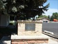
 view gallery view galleryE14.6 km | Mona Bicentennial Memorial Park in Utah Historical Markers This monument commemorates America's Bicentennial and appreciation for Mona's school teachers and staff. posted by: brwhiz location: Utah date approved: 04/09/2011 last visited: 10/05/2011 |
 view gallery view galleryE14.6 km |  Mona Bicentennial Memorial Park Mona Bicentennial Memorial Park
in Community Commemoration This monument commemorates America's Bicentennial and appreciation for Mona's school teachers and staff. posted by: brwhiz location: Utah date approved: 04/16/2011 last visited: 10/05/2011 |
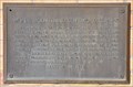 view gallery view galleryE14.6 km |  Mona Bicentennial Memorial Park Mona Bicentennial Memorial Park
in Citizen Memorials This monument commemorates America's Bicentennial and appreciation for Mona's School teachers, staff, students, and citizens. posted by: brwhiz location: Utah date approved: 04/10/2011 last visited: 10/05/2011 |
 view gallery view galleryE14.6 km |  Mona, Utah 84645 Mona, Utah 84645
in U.S. Post Offices The Post Office serving Mona, Utah. posted by: JacobBarlow location: Utah date approved: 09/11/2007 last visited: 10/05/2011 |
 view gallery view galleryE14.8 km |  First Grave in Mona First Grave in Mona
in First of its Kind Nancy Maria Biglow Love was the first burial in the new community of Mona. posted by: brwhiz location: Utah date approved: 03/24/2011 last visited: 10/04/2021 |
 view gallery view galleryE14.8 km | Old Pioneer Cemetery ~ 29 in D.U.P. Historic Markers This is a small cemetery, serving a community of few people, for a relatively short period of time. posted by: brwhiz location: Utah date approved: 03/24/2011 last visited: 10/04/2021 |
 view gallery view galleryE14.8 km | Old Pioneer Cemetery in Utah Historical Markers This monument is erected in memory of the pioneers buried here, there are about 20 whose resting place surrounds this monument.... posted by: JacobBarlow location: Utah date approved: 09/11/2007 last visited: 10/04/2021 |
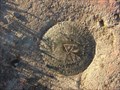
 view gallery view galleryE14.8 km | Benchmark: KN0325 " M 55 " in U.S. Benchmarks This Benchmark was recovered in good condition just as described. posted by: JacobBarlow location: Utah date approved: 11/20/2007 last visited: 11/20/2007 |
 view gallery view galleryE14.8 km |  Mona, Utah Mona, Utah
in Wikipedia Entries Mona is a town in Juab County, Utah, United States. The population was 850 at the 2000 census. posted by: JacobBarlow location: Utah date approved: 12/01/2007 last visited: 09/11/2016 |
 view gallery view galleryE15 km | Benchmark: KN0448 " MONA " RM 1 in U.S. Benchmarks This is reference mark # 1 for Benchmark: KN0448 " MONA " posted by: JacobBarlow location: Utah date approved: 11/20/2007 last visited: 02/22/2019 |
 view gallery view galleryE15 km | Benchmark: KN0448 " MONA " in U.S. Benchmarks Good condition and easy to find, just off the Cemetery road in Mona. posted by: JacobBarlow location: Utah date approved: 11/20/2007 last visited: 02/22/2019 |
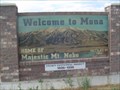
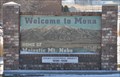 view gallery view galleryE15.4 km |  Welcome to Mona, Utah - Eastern Approach Welcome to Mona, Utah - Eastern Approach
in Welcome Signs Welcome to Mona, Home of Majestic Mt. Nebo. This sign welcomes you as you approach Mona from the east on Utah Highway 54. posted by: brwhiz location: Utah date approved: 04/16/2011 last visited: 10/05/2011 |
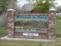 view gallery view galleryE15.4 km |  Welcome to Mona - Mona, Utah Welcome to Mona - Mona, Utah
in Artistic Welcome Signs Welcome to Mona, Home of Majestic Mt. Nebo. This sign welcomes you as you approach Mona from the east on Utah Highway 54. posted by:  Lord Mot Lord Mot location: Utah date approved: 05/26/2011 last visited: 10/05/2011 |
 view gallery view gallery SE15.6 km SE15.6 km
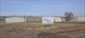
|  Nephi Municipal Airport ~ Nephi, UT Nephi Municipal Airport ~ Nephi, UT
in Airports This small general aviation airport serves as the municipal airport for the town of Nephi, Utah. posted by: brwhiz location: Utah date approved: 05/16/2012 last visited: never |
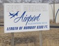 view gallery view gallerySE15.8 km |  Nephi Municipal Airport ~ Elevation 5010 feet Nephi Municipal Airport ~ Elevation 5010 feet
in Elevation Signs The Nephi Municipal Airport at Nephi Utah is at an altitude of 5010 feet. posted by: brwhiz location: Utah date approved: 03/07/2012 last visited: never |
|