 view gallery view gallery E1 km E1 km
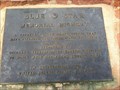
|   Berthoud Pass - Berthoud Pass, CO Berthoud Pass - Berthoud Pass, CO
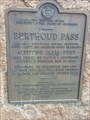
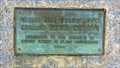
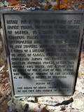
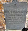
in Colorado Historical Markers This historical marker is located at the summit of Berthoud Pass at an elevation of 11,307 ft. posted by:  mr.volkswagen mr.volkswagen location: Colorado date approved: 08/19/2017 last visited: 08/17/2017 |
 view gallery view galleryE1 km |  Berthoud Pass, CO (11,307 ft) Berthoud Pass, CO (11,307 ft)
in Elevation Signs Located on the Continental Divide of Highway 40. posted by: mr.volkswagen location: Colorado date approved: 08/21/2017 last visited: 08/21/2017 |
 view gallery view gallery S1.3 km S1.3 km
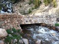
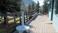
|  Hoop Creek Stone Bridge on Berthoud Pass US 40 Hoop Creek Stone Bridge on Berthoud Pass US 40
in Stone Bridges Decommissioned stoned bridge built in 1921 with view of Hoop Creek Waterfall. posted by: GreencoreOutfitters location: Colorado date approved: 06/06/2015 last visited: 07/15/2017 |
 view gallery view gallery SE9.5 km SE9.5 km
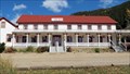
|  Peck House - Empire, CO Peck House - Empire, CO
in Antique Hotels The Peck House is the oldest hotel extant in the state [Colorado}. Many of the antiques used throughout the hotel came by oxcart with the Peck family in 1862. posted by: Outspoken1 location: Colorado date approved: 10/09/2012 last visited: 05/13/2013 |
 view gallery view gallerySE9.5 km |  Peck House - Empire, CO Peck House - Empire, CO
in U.S. National Register of Historic Places The Peck House is the oldest hotel extant in the state [Colorado}. Many of the antiques used throughout the hotel came by oxcart with the Peck family in 1862. posted by: Outspoken1 location: Colorado date approved: 10/06/2012 last visited: 05/13/2013 |
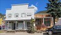 view gallery view gallerySE9.7 km | Mint Saloon - Empire, CO in U.S. National Register of Historic Places The Mint Saloon is the one story structure to the right, though the city placed the historic plaque on the two story structure that is NOT on the NRHP! posted by: Outspoken1 location: Colorado date approved: 10/06/2012 last visited: never |
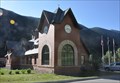
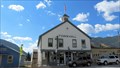 view gallery view gallerySE9.7 km |  Empire, Colorado, USA Empire, Colorado, USA
in City and Town Halls Empire was a mining town that has sadly become more of a drive-thru on the way to the ski slopes. posted by: Outspoken1 location: Colorado date approved: 10/06/2012 last visited: 05/13/2013 |
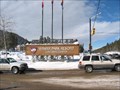
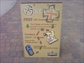
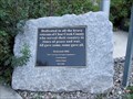
 view gallery view gallerySE9.7 km |  Visitor Center - Empire, CO Visitor Center - Empire, CO
in Coin-Op Binoculars This unstaffed Visitor Center does feature two coin-operated binoculars. posted by: Outspoken1 location: Colorado date approved: 10/06/2012 last visited: never |
 view gallery view gallerySE9.7 km | Valley City - Empire, CO in Colorado Historical Markers This little plaque was nicely landscaped on the city of Empire. posted by: Outspoken1 location: Colorado date approved: 10/06/2012 last visited: never |
 view gallery view gallery N9.8 km N9.8 km
|  Winter Park/Mary Jane Resort/-Colorado Winter Park/Mary Jane Resort/-Colorado
in Winter Sports Locations "Colorado's Favorite"-Winter Park with over 359 inches / 9.1 meters, has the most consistent snow season after season.
posted by:  Team Min Dawg Team Min Dawg location: Colorado date approved: 01/22/2006 last visited: 05/13/2013 |
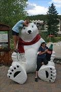 view gallery view galleryN10 km |  Coca-Cola Polar Bear - Winter Park, CO Coca-Cola Polar Bear - Winter Park, CO
in Coca Cola Memorabilia Located in Winter Park Village . posted by: mr.volkswagen location: Colorado date approved: 08/19/2017 last visited: 08/17/2017 |
 view gallery view galleryN10.1 km |  The Village Ski Resort at Winter Park - Geocaching 101 The Village Ski Resort at Winter Park - Geocaching 101
in Geocaching Tour Guides A geocaching course at "The Village" in Winter Park Ski Resort posted by: Team gEco Friendly location: Colorado date approved: 09/04/2011 last visited: never |
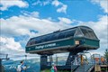 view gallery view galleryN10.1 km |  Zephyr Express - Winter Park, CO Zephyr Express - Winter Park, CO
in Aerial Lifts The Zephyr Express lift begins in Winter Parks main base village. posted by: mr.volkswagen location: Colorado date approved: 08/24/2017 last visited: 08/23/2017 |
 view gallery view galleryN10.3 km | The Pioneer Bore of the Moffat Tunnel - Winter Park, CO in Colorado Historical Markers The Pioneer Bore is the water system that runs along the Moffat Tunnel posted by: mr.volkswagen location: Colorado date approved: 08/24/2017 last visited: 08/23/2017 |
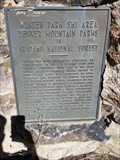 view gallery view galleryN10.3 km | Winter Park Ski Area - Winter Park, CO in Colorado Historical Markers Bronze plaque is mounted on a stone wall just off US Highway 40. posted by: mr.volkswagen location: Colorado date approved: 08/28/2017 last visited: 08/27/2017 |
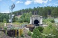 view gallery view galleryN10.3 km |  Moffat Tunnel Moffat Tunnel
in Wikipedia Entries The Moffat Tunnel is a Railroad and water tunnel that cuts through the Continental Divide in North-Central Colorado. posted by: mr.volkswagen location: Colorado date approved: 09/08/2017 last visited: 10/16/2020 |
 view gallery view galleryN10.3 km | Moffat Tunnel West Portal - Winter Park Village, CO in Colorado Historical Markers The Moffat Tunnel is a Railroad and water tunnel that cuts through the Continental Divide in North-Central Colorado. posted by: mr.volkswagen location: Colorado date approved: 08/23/2017 last visited: 08/21/2017 |
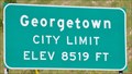 view gallery view gallerySE10.8 km | Georgetown, Colorado (Northern Approach) ~ Elevation 8519 Feet in Elevation Signs This Elevation Sign is located on the west side of Interstate Highway 70 at the northern town limits of Georgetown, Colorado. posted by: brwhiz location: Colorado date approved: 02/10/2013 last visited: 04/26/2017 |
 view gallery view galleryN11.6 km |  US-40 & Winter Park Dr. - Winter Park, CO US-40 & Winter Park Dr. - Winter Park, CO
in Blue Star Memorial Highway Markers Blue Star Memorial Highway Marker. posted by: GreencoreOutfitters location: Colorado date approved: 06/02/2015 last visited: 06/18/2015 |
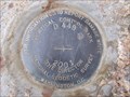 view gallery view gallerySE11.7 km |  DF5474 (D449) - Clear Creek : Empire, CO, USA DF5474 (D449) - Clear Creek : Empire, CO, USA
in U.S. Benchmarks Nearby Empire, CO on a county (i.e. public) right-of-way.
Great hiking area!
Historically rich area and the gold ain't bad either.
There's an Easter Seals(tm) camp, Frisbee(tm) golf and even a serene cemetery to explore. posted by: MrCOgeo location: Colorado date approved: 06/10/2009 last visited: 09/12/2014 |
 view gallery view gallerySE11.9 km |  Gateway Visitor Center Clock ~ Georgetown, Colorado Gateway Visitor Center Clock ~ Georgetown, Colorado
in Town Clocks This Town Clock is mounted on the Gateway Visitor Center at 1491 Argentine Street in Georgetown, Colorado. posted by: brwhiz location: Colorado date approved: 02/07/2013 last visited: 02/16/2020 |
 view gallery view gallerySE11.9 km |  Veterans of Clear Creek County Memorial - Georgetown, CO Veterans of Clear Creek County Memorial - Georgetown, CO
in Non-Specific Veteran Memorials Veterans Memorial to Clear Creek County service members posted by: Outspoken1 location: Colorado date approved: 10/31/2010 last visited: 04/26/2017 |
 view gallery view gallerySE11.9 km | Georgetown, Colorado, USA - Elevation 8,500 feet in Elevation Signs Last indoor potty stop before Eisenhower Tunnels!! 8,500 feet converts to 2,590.8 meters. posted by: Outspoken1 location: Colorado date approved: 03/02/2014 last visited: 04/03/2015 |
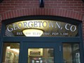
 view gallery view gallerySE11.9 km |  Georgetown, Colorado, USA - Pop. 1,100 Georgetown, Colorado, USA - Pop. 1,100
in Population Signs The population of the small mountain community of Georgetown is found on the entrance to the visitor center. posted by: Outspoken1 location: Colorado date approved: 03/04/2014 last visited: 04/03/2015 |
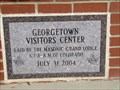 view gallery view gallerySE11.9 km |  2004 - Georgetown Visitors Center - Georgetown, CO 2004 - Georgetown Visitors Center - Georgetown, CO
in Dated Buildings and Cornerstones Recently built visitors center is now the last stop for a bathroom before Eisenhower Tunnel posted by: Outspoken1 location: Colorado date approved: 10/27/2010 last visited: 04/26/2017 |
|