 view gallery view gallery SW1.3 km SW1.3 km
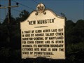
|   New Munster New Munster
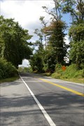
in Maryland Historical Markers Historical marker along Telegraph Road commemoration original surveying of land in area. posted by:  BruceS BruceS location: Maryland date approved: 07/17/2008 last visited: never |
 view gallery view gallery W2.1 km W2.1 km
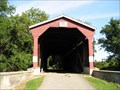
|  Foxcatcher Farm Covered Bridge - Fair Hill, MD Foxcatcher Farm Covered Bridge - Fair Hill, MD
in Satellite Imagery Oddities An original plank road is featured on this Bowstring (chord type) and Howe Truss Bridge, built between 1850 and 1860 and located on Tawes Drive in the Fairview Hill Natural Resource Management Area in Cecil County, Maryland. posted by:  Math Teacher Math Teacher location: Maryland date approved: 09/01/2013 last visited: never |
 view gallery view galleryW2.1 km |  Foxcatcher Farm Covered Bridge - Fair Hill, MD Foxcatcher Farm Covered Bridge - Fair Hill, MD
in Covered Bridges This Bowstring (chord type) and Howe Truss Bridge was built between 1850 and 1860 and is located on Tawes Drive in the Fairview Hill Natural Resource Management Area in Cecil County, Maryland. posted by: Math Teacher location: Maryland date approved: 08/19/2007 last visited: 10/16/2011 |
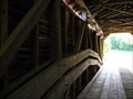 view gallery view galleryW2.1 km |  Foxcatcher Farm Covered Bridge - Fair Hill, MD Foxcatcher Farm Covered Bridge - Fair Hill, MD
in Plank Roads An original plank road is featured on this Bowstring (chord type) and Howe Truss Bridge, built between 1850 and 1860 and located on Tawes Drive in the Fairview Hill Natural Resource Management Area in Cecil County, Maryland. posted by: Math Teacher location: Maryland date approved: 09/01/2013 last visited: never |
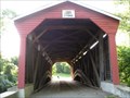 view gallery view galleryW2.1 km |  Foxcatcher Farm Covered Bridge - Fair Hill, MD Foxcatcher Farm Covered Bridge - Fair Hill, MD
in Truss Bridges This Bowstring (chord type) and Howe Truss Bridge was built between 1850 and 1860 and is located on Tawes Drive in the Fairview Hill Natural Resource Management Area in Cecil County, Maryland. posted by: Math Teacher location: Maryland date approved: 09/06/2010 last visited: 10/16/2011 |
 view gallery view gallery N2.1 km N2.1 km
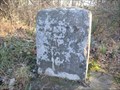
|  MASDIX West Line Stone 2, 1766, Maryland - Pennsylvania MASDIX West Line Stone 2, 1766, Maryland - Pennsylvania
in U.S. Historic Survey Stones and Monuments MASDIX West Line Stone 2, 1766, PA-MD, is a dressed Portland Stone shaft set by Mason and Dixon in 1766 to demarcate the boundary between PA and MD. posted by: seventhings location: Pennsylvania date approved: 01/04/2007 last visited: 03/04/2021 |
 view gallery view gallery E2.3 km E2.3 km
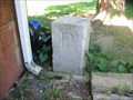
| MASDIX North Line Mile 86, 1766, Delaware - Maryland in U.S. Historic Survey Stones and Monuments MASDIX North Line Mile 86, 1766, DE-MD, is a dressed Portland Stone shaft set by Mason and Dixon in 1766 to demarcate the boundary between DE and MD. posted by: seventhings location: Delaware date approved: 07/01/2007 last visited: 10/06/2017 |
 view gallery view gallery SE2.4 km SE2.4 km
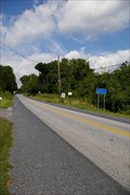
|  Delaware/Maryland - MD/DE RT 273 - Elkton MD Delaware/Maryland - MD/DE RT 273 - Elkton MD
in Border Crossings Road goes from Nottingham Rd in Delaware to Telegraph Rd in Maryland. posted by:  nomadwillie nomadwillie location: Maryland date approved: 11/11/2016 last visited: never |
 view gallery view gallerySE2.6 km | MASDIX North Line Mile 85, 1766, Delaware - Maryland in U.S. Historic Survey Stones and Monuments MASDIX North Line Mile 85, 1766, DE-MD, is a dressed Portland Stone shaft set by Mason and Dixon in 1766 to demarcate the boundary between DE and MD. posted by: seventhings location: Delaware date approved: 06/12/2008 last visited: never |
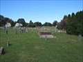 view gallery view gallerySE2.7 km |  Head of Christiana Church Cemetery - Newark, Delaware Head of Christiana Church Cemetery - Newark, Delaware
in Worldwide Cemeteries Cemetery adjacent to historic Presbyterian church just east of the Delaware-Maryland border near Newark, Delaware. posted by: BruceS location: Delaware date approved: 01/10/2014 last visited: never |
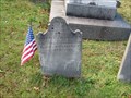
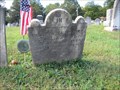 view gallery view gallerySE2.7 km |  William Crawford - Newark, Delaware William Crawford - Newark, Delaware
in American Revolutionary War Veteran Graves Grave of Revolutionary War veteran in the Head of Christiana Presbyterian Church Cemetery near Newark, Delaware. posted by: BruceS location: Delaware date approved: 01/19/2014 last visited: never |
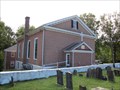
 view gallery view gallerySE2.7 km |  Head of Christiana Presbyterian Church (NC-115) - Newark, DE Head of Christiana Presbyterian Church (NC-115) - Newark, DE
in Delaware Historical Markers Located on Church Road, to the south of Nottingham Road (DE273), just east of the state line. posted by: S5280ft location: Delaware date approved: 07/17/2008 last visited: 10/13/2013 |
 view gallery view gallerySE2.7 km | Thomas Bradley - Newark, Delaware in American Revolutionary War Veteran Graves Grave of Revolutionary War veteran in the Head of Christiana Presbyterian Church Cemetery near Newark, Delaware. posted by: BruceS location: Delaware date approved: 01/19/2014 last visited: never |
 view gallery view gallerySE2.7 km | Levi Davis - Newark, Delaware in American Revolutionary War Veteran Graves Grave of Revolutionary War veteran in the Head of Christiana Presbyterian Church Cemetery near Newark, Delaware. posted by: BruceS location: Delaware date approved: 01/19/2014 last visited: never |
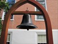 view gallery view gallerySE2.7 km |  Head of Christiana United Presbyterian Church Bell - Newark, Delaware Head of Christiana United Presbyterian Church Bell - Newark, Delaware
in Bells Bell at historic Head of Christiana United Presbyterian Church in Newark, Delaware. posted by: BruceS location: Delaware date approved: 01/08/2014 last visited: never |
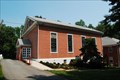
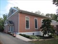 view gallery view gallerySE2.7 km |  Head of Christiana United Presbyterian Church - Newark, Delaware Head of Christiana United Presbyterian Church - Newark, Delaware
in Presbyterian Churches Historic Presbyterian Church located just east of the Delaware-Maryland border on Church Road, to the south of Nottingham Road (DE273). posted by: BruceS location: Delaware date approved: 01/09/2014 last visited: never |
 view gallery view gallerySE2.7 km |  Head of Christiana United Presbyterian Church - Newark, Delaware Head of Christiana United Presbyterian Church - Newark, Delaware
in Wikipedia Entries Historic Presbyterian Church located just east of the Delaware-Maryland border on Church Road, to the south of Nottingham Road (DE273). posted by: BruceS location: Delaware date approved: 01/07/2014 last visited: never |
 view gallery view gallerySE2.7 km |  Head of Christiana United Presbyterian Church - Newark, Delaware Head of Christiana United Presbyterian Church - Newark, Delaware
in U.S. National Register of Historic Places Historic Presbyterian Church located just east of the Delaware-Maryland border on Church Road, to the south of Nottingham Road (DE273). posted by: BruceS location: Delaware date approved: 01/08/2014 last visited: never |
 view gallery view gallerySE2.7 km |  Head of Christiana United Presbyterian Church - Newark, Delaware Head of Christiana United Presbyterian Church - Newark, Delaware
in This Old Church Historic Presbyterian Church located just east of the Delaware-Maryland border on Church Road, to the south of Nottingham Road (DE273). posted by: BruceS location: Delaware date approved: 01/08/2014 last visited: never |
 view gallery view gallerySE2.7 km |  Head of Christiana Presbyterian Church - Newark, Delaware Head of Christiana Presbyterian Church - Newark, Delaware
in American Guide Series Historic Presbyterian Church located just east of the Delaware-Maryland border. posted by: BruceS location: Delaware date approved: 01/09/2014 last visited: never |
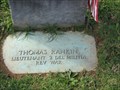 view gallery view gallerySE2.7 km | Lieutenant Thomas Rankin - Newark, Delaware in American Revolutionary War Veteran Graves Grave of Revolutionary War veteran in the Head of Christiana Presbyterian Church Cemetery near Newark, Delaware. posted by: BruceS location: Delaware date approved: 01/19/2014 last visited: never |
 view gallery view gallery NE2.9 km NE2.9 km
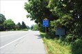
| Delaware/Maryland Border at DE896/MD896 in Border Crossings Rural border crossing near the point where Delaware, Maryland & Pennsylvania meet. posted by: Ernmark location: Delaware date approved: 09/19/2008 last visited: 09/25/2010 |
 view gallery view galleryNE2.9 km | Maryland/Pennsylvania Border at MD896/PA896 in Border Crossings Rural border crossing near the point where Delaware, Maryland & Pennsylvania meet. posted by: Ernmark location: Maryland date approved: 09/19/2008 last visited: 09/25/2010 |
 view gallery view galleryNE3.1 km | The Wedge (NC-36) - Newark, DE in Delaware Historical Markers Located on the north side of New London Road (DE-896), just inside the state border. posted by: S5280ft location: Delaware date approved: 07/17/2008 last visited: 10/30/2009 |
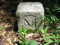
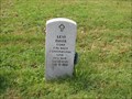
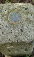 view gallery view galleryNE3.1 km |  BOUNDARY MON 87 DE MD PA=RM 2 (JU3841) - DE / MD / PA BOUNDARY MON 87 DE MD PA=RM 2 (JU3841) - DE / MD / PA
in U.S. Benchmarks A USC&GS Reference Mark disk sits atop a small granite post a few feet west of a hiking trail - it marks the exact spot where Delaware, Maryland & Pennsylvania meet. posted by: Ernmark location: Maryland date approved: 08/21/2009 last visited: 05/29/2022 |
|