 view gallery view gallery SW23.3 km SW23.3 km
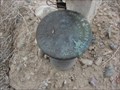
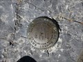
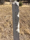
|   U. S. Cadastral Survey Marker - Gandy, Utah U. S. Cadastral Survey Marker - Gandy, Utah
in U.S. Benchmarks Another Benchmark at a fence corner in Gandy, Utah. posted by:  JacobBarlow JacobBarlow location: Utah date approved: 09/18/2007 last visited: 09/19/2007 |
 view gallery view gallerySW23.7 km | Cadastral Survey Marker - Gandy, Utah in U.S. Benchmarks The Benchmark is at a fence corner in Gandy, Utah. posted by: JacobBarlow location: Utah date approved: 09/18/2007 last visited: 09/19/2007 |
 view gallery view gallery N44.7 km N44.7 km
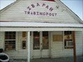
|  Ibapah Trading Post Ibapah Trading Post
in Payphones Working Payphone located at the Ibapah Trading post in Ibapah Utah. There is no cell service here so this is the only link to the outside world. posted by:  caverspencer caverspencer location: Utah date approved: 02/25/2007 last visited: never |
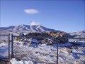 view gallery view galleryN45.2 km |  Canyon Station Canyon Station
in Pony Express Monuments Canyon Station Ruins located in Overland Canyon near Ibapah, Utah posted by: caverspencer location: Utah date approved: 02/16/2007 last visited: 11/30/2008 |
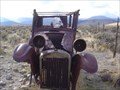 view gallery view gallerySW48.6 km |  Old Car near Baker, NV (Great Basin NP) Old Car near Baker, NV (Great Basin NP)
in Abandoned Dead Vehicles Old Car near a roadside interpretive display on the way up to Lehman Cave. posted by:  Uncle Alaska Uncle Alaska location: Nevada date approved: 11/23/2005 last visited: 09/05/2010 |
 view gallery view gallerySW48.9 km | MT MORIAH (KP0314) - White Pine County, NV in U.S. Benchmarks Benchmark at the high point of Mount Moriah. posted by: valhikes location: Nevada date approved: 01/29/2024 last visited: 10/24/2023 |
 view gallery view gallery S55.4 km S55.4 km
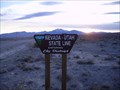
|  Utah Nevada, Gandy Utah Utah Nevada, Gandy Utah
in Border Crossings Border Crossing on a main Gravel road near Gandy Utah posted by: caverspencer location: Utah date approved: 02/25/2007 last visited: 10/22/2023 |
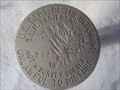
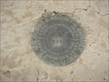 view gallery view galleryS55.5 km | Benchmark: KP0042 in U.S. Benchmarks We were out exploring the desert and came across this cool Benchmark on the State Line of Nevada & Utah. posted by: JacobBarlow location: Utah date approved: 09/18/2007 last visited: 09/19/2007 |
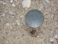 view gallery view galleryS55.5 km | 1/4 919 UTAH in U.S. Benchmarks Near the Nevada / Utah State Line we found this Benchmark placed in 1942. posted by: JacobBarlow location: Utah date approved: 09/18/2007 last visited: 09/19/2007 |
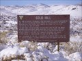 view gallery view galleryN58.4 km |  Gold Hill, Utah Gold Hill, Utah
in Ghost Towns Gold Hill posted by: caverspencer location: Utah date approved: 02/16/2007 last visited: never |
 view gallery view gallerySW64.7 km |  Black Horse Cemetery - White Pine County, NV Black Horse Cemetery - White Pine County, NV
in Worldwide Cemeteries Small graveyard near the former Black Horse town site. posted by: valhikes location: Nevada date approved: 01/22/2024 last visited: 10/13/2023 |
 view gallery view gallerySW66 km | NORTH SHELL (KP0332) - White Pine County, Nevada in U.S. Benchmarks This triangulation station is located atop the summit of North Schell Peak, which is the highpoint of the Schell Creek Range, the 8th highest ranked peak in Nevada, and 40th most prominent mountain summit in the Lower 48. posted by: Tom.dog location: Nevada date approved: 02/27/2023 last visited: 11/01/2023 |
 view gallery view galleryS66.1 km | USCGS KO0473 ~ Sorenson Azimuth Mark in U.S. Benchmarks This Azimuth Mark is several miles east of the Utah/Nevada border on US Highway 50/6. posted by: brwhiz location: Utah date approved: 03/28/2012 last visited: 08/27/2012 |
 view gallery view galleryS66.6 km |  Welcome to Utah ~ Life Elevated Welcome to Utah ~ Life Elevated
in Welcome Signs This Welcome Sign is located on the south side of US Highway 6 & 50, a few yards east of the Nevada/Utah border. posted by: brwhiz location: Utah date approved: 05/17/2013 last visited: 01/04/2014 |
 view gallery view galleryS66.6 km | Utah- Nevada Highway 6 in Border Crossings Border Crossing near Garrison on US 6 posted by: caverspencer location: Utah date approved: 02/25/2007 last visited: 07/03/2017 |
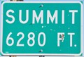 view gallery view galleryS66.9 km |  US Highway 50 & 6 Summit ~ Elevation 6280 feet US Highway 50 & 6 Summit ~ Elevation 6280 feet
in Elevation Signs This summit is the high point on US Highway 50 & 6 between Hincley and the Utah Nevada border. posted by: brwhiz location: Utah date approved: 03/28/2012 last visited: never |
 view gallery view gallery W67.4 km W67.4 km
| Schellbourne Pass in Pony Express Monuments Pony Express route marker at Schellbourne Pass, Nevada. posted by: Volcanoguy location: Nevada date approved: 01/17/2017 last visited: 09/29/2016 |
 view gallery view galleryW67.4 km | Schellbourne Pass, Nevada in U.S. Benchmarks Located on the original route of the Pony Express posted by: Uncle Alaska location: Nevada date approved: 12/12/2005 last visited: 09/29/2016 |
 view gallery view gallerySW67.4 km | Sacramento Pass - Elevation 7154 in Elevation Signs Elevation sign at Sacramento Pass. posted by: Volcanoguy location: Nevada date approved: 03/03/2017 last visited: 09/30/2016 |
 view gallery view gallerySW68.1 km |  Sacramento Pass Recreation Area Sacramento Pass Recreation Area
in 'You Are Here' Maps You Are Here marker at Sacramento Pass Recreation Area. posted by: Volcanoguy location: Nevada date approved: 03/13/2017 last visited: 08/24/2019 |
 view gallery view gallerySW68.1 km |  Sacramento Pass Recreation Area Sacramento Pass Recreation Area
in Nevada Historical Markers History information on area information sign at Sacramento Pass Recreation Area. posted by: Volcanoguy location: Nevada date approved: 03/16/2017 last visited: 08/24/2019 |
 view gallery view galleryS68.4 km | KP0317 - USCGS WYTE NO 1 - 1957 - Nevada in U.S. Benchmarks U.S. Coast & Geodetic Survey reference mark WYTE NO 1. posted by: Volcanoguy location: Nevada date approved: 03/12/2017 last visited: 09/30/2016 |
 view gallery view galleryS68.6 km | KP0317 - USCGS WYTE - 1957 - Nevada in U.S. Benchmarks U.S. Coast & Geodetic Survey triangulation station WYTE. posted by: Volcanoguy location: Nevada date approved: 03/12/2017 last visited: 09/30/2016 |
 view gallery view galleryS68.6 km | KP0317 - USCGS WYTE NO 2 - 1957 - Nevada in U.S. Benchmarks U.S. Coast & Geodetic Survey reference mark WYTE NO 2. posted by: Volcanoguy location: Nevada date approved: 03/12/2017 last visited: 09/30/2016 |
 view gallery view galleryS70.5 km |  Baker Village Trail - Baker Archeological Site - Nevada Baker Village Trail - Baker Archeological Site - Nevada
in Self Guided Walks and Trails Self guided trail the BLM’s Baker Village interpretive site. posted by: Volcanoguy location: Nevada date approved: 03/18/2017 last visited: 09/30/2016 |
|