 view gallery view gallery SE3.1 km SE3.1 km
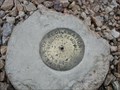
|   Bureau of Reclamation - Webster Pass - Colorado Bureau of Reclamation - Webster Pass - Colorado
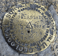
in U.S. Benchmarks Bronze disk on a concrete monument at the crest of Webster Pass near Montezuma CO. On the Continental Divide. Cannot find any datasheet for this benchmark, but it is shown on the topo map of the area. posted by:  mess50 mess50 location: Colorado date approved: 08/03/2007 last visited: 08/30/2016 |
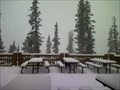 view gallery view gallery W6.9 km W6.9 km
|  The Outpost Lodge The Outpost Lodge
in Ski Lodges The Outpost Lodge at Keystone posted by:  mappicus mappicus location: Colorado date approved: 12/30/2006 last visited: 06/07/2006 |
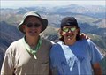 view gallery view gallery N9.3 km N9.3 km
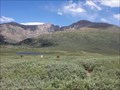
|  Grays Peak Grays Peak
in Mountain Summits One of the easier Colorado 14ers. posted by: t-xman location: Colorado date approved: 09/10/2005 last visited: 08/19/2010 |
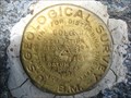 view gallery view gallery NE9.8 km NE9.8 km
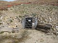
| US Geological Survey benchmark COLO KII 1924 in U.S. Benchmarks USGS benchmark on Argentine Pass posted by: jkselby location: Colorado date approved: 08/13/2009 last visited: never |
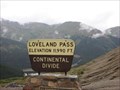 view gallery view galleryN12.4 km |  Loveland Pass, Colorado Loveland Pass, Colorado
in Elevation Signs Loveland Pass, just east of the Loveland ski area posted by: ronjean location: Colorado date approved: 09/07/2008 last visited: 07/06/2015 |
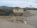 view gallery view galleryN12.4 km |  Loveland Pass Loveland Pass
in Wikipedia Entries Loveland Pass is a mountain pass on the continental divide in the Rocky Mountains in Colorado. The elevation of the pass is 11,990 feet above sea level. posted by: adenium location: Colorado date approved: 09/16/2010 last visited: 07/06/2015 |
 view gallery view gallery E12.9 km E12.9 km
|  Mount Bierstadt Trailhead Mount Bierstadt Trailhead
in Hiking and walking trailheads Mount Bierstadt trailhead is located at 11,065ft above sea level, just off of Guanella Pass. posted by: Team Laxson location: Colorado date approved: 07/07/2010 last visited: 07/09/2015 |
 view gallery view galleryN13.8 km | U.S. Dept. of Agriculture Forest Service AS P 551 1939 in U.S. Benchmarks Forest Service mark on summit of Mt. Sniktau posted by: jkselby location: Colorado date approved: 11/25/2010 last visited: 08/13/2014 |
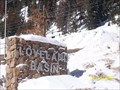 view gallery view galleryN14.5 km |  Loveland Basin Ski Area - Colorado Loveland Basin Ski Area - Colorado
in Winter Sports Locations Loveland Pass and Loveland Basin are two seperate sections of Loveland Ski Resort located in beautiful Georgetown, CO.
posted by: ganurse location: Colorado date approved: 01/27/2008 last visited: 03/02/2008 |
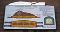
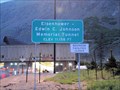
 view gallery view galleryN14.6 km |  Eisenhower Memorial Tunnel - Colorado Eisenhower Memorial Tunnel - Colorado
in Colorado Historical Markers Eisenhower Memorial Tunnels on I-70 in Colorado Central Mountain corridor posted by: Outspoken1 location: Colorado date approved: 02/02/2008 last visited: 11/08/2019 |
 view gallery view galleryN14.6 km |  HIGHEST & LONGEST & FIRST - Eisenhower-Johnson Memorial Tunnels - Colorado HIGHEST & LONGEST & FIRST - Eisenhower-Johnson Memorial Tunnels - Colorado
in Superlatives Simple known as "the Tunnel' in Colorado, these feats of engineering are critical to transportation in the United States posted by: Outspoken1 location: Colorado date approved: 08/07/2010 last visited: 07/18/2014 |
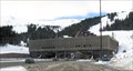 view gallery view galleryN14.6 km |  Eisenhower-Johnson Memorial Tunnel and Related Highway - Colorado Eisenhower-Johnson Memorial Tunnel and Related Highway - Colorado
in Engineering Landmarks Eisenhower-Johnson Tunnel is both the highest and longest auto tunnel on Colorado's I-70 corridor. The the ASCE bestowed on CDOT the 1993 Outstanding Civil Engineering Achievement Award for this section of highway. posted by: Outspoken1 location: Colorado date approved: 08/05/2012 last visited: 02/04/2023 |
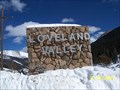 view gallery view galleryN14.6 km | Loveland Valley Ski Area - Colorado in Winter Sports Locations Loveland Pass and Loveland Basin are two seperate sections of Loveland Ski Resort located in beautiful Georgetown, CO. posted by: ganurse location: Colorado date approved: 01/27/2008 last visited: 03/02/2008 |
 view gallery view gallery SW15.1 km SW15.1 km
|  Carbonate Mine - Summit County, Colorado Carbonate Mine - Summit County, Colorado
in Mines A small working mine above timberline in Summit County, Colorado. Established in 1899, that Carbonate Mine is a producer of silver, zinc, and lead. posted by: adenium location: Colorado date approved: 09/17/2010 last visited: 09/12/2010 |
 view gallery view gallery NW15.6 km NW15.6 km
| Edwin C. Johnson Memorial Tunnel - Summit County, CO USA - 11,158' in Elevation Signs Elevation sign on westbound I-70 at 'The Tunnel' posted by: Outspoken1 location: Colorado date approved: 08/07/2010 last visited: 06/22/2018 |
 view gallery view galleryE15.9 km | Mount Bierstadt in Wikipedia Entries Mount Bierstadt is a mountain in the Front Range region of the Rocky Mountains, in Clear Creek County, Colorado. It is one of 54 fourteeners in Colorado. It is located approximately 1.5 miles WSW of Mount Evans. posted by: Team Laxson location: Colorado date approved: 07/08/2010 last visited: 08/16/2020 |
 view gallery view galleryE15.9 km |  Mount Bierstadt Summit Register (14,060) Mount Bierstadt Summit Register (14,060)
in Summit Registers Mount Bierstadt is the 39th tallest peak in Colorado, towering 14,060 feet above sea level. posted by: Team Laxson location: Colorado date approved: 07/06/2010 last visited: 08/16/2020 |
 view gallery view galleryE15.9 km |  Mount Bierstadt Summit Trail Mount Bierstadt Summit Trail
in Scenic Hikes Mount Bierstadt is the 39th tallest peak in Colorado, towering 14,060 feet posted by: Team Laxson location: Colorado date approved: 07/07/2010 last visited: 09/10/2020 |
 view gallery view galleryE15.9 km | Mount Bierstadt Summit (14,060) in Mountain Summits Mount Bierstadt is the 39th tallest peak in Colorado, towering 14,060 feet above sea level. posted by: Team Laxson location: Colorado date approved: 07/06/2010 last visited: 08/16/2020 |
 view gallery view galleryE15.9 km | KK2029 Bierstadt - Clear Creek County, CO in U.S. Benchmarks Survey Disk in Rock Outcrop on the summit of Mount Bierstadt. posted by: animjason location: Colorado date approved: 07/10/2015 last visited: 09/10/2020 |
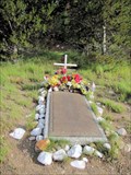 view gallery view galleryN15.9 km |  1970 Wichita State Football Team Crash - Summit County, CO 1970 Wichita State Football Team Crash - Summit County, CO
in Plane Crash Sites Crash in 1970 killed 31 of the 40 on board of the Wichita State University Football Team posted by: Outspoken1 location: Colorado date approved: 07/11/2010 last visited: 10/06/2014 |
 view gallery view galleryN15.9 km | 1970 Wichita State Football Team Crash - Summit County, CO in Colorado Historical Markers Crash in 1970 killed 31 of the 40 on board of the Wichita State University Football Team posted by: Outspoken1 location: Colorado date approved: 07/11/2010 last visited: 10/06/2014 |
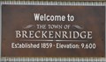 view gallery view galleryW16.6 km | Breckenridge, Colorado ~ Elevation 9600 Feet in Elevation Signs This Elevation is inscribed on the Welcome Sign at the northern city limits of Breckenridge, Colorado. posted by: brwhiz location: Colorado date approved: 02/15/2013 last visited: never |
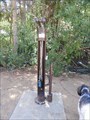 view gallery view gallerySW17.2 km |  Wellington Bike Park - Breckenridge, CO, USA Wellington Bike Park - Breckenridge, CO, USA
in Bicycle Repair Stations This tool unit is at the entrance of the Wellington Bike Park in Breckenridge, CO, USA. posted by: Outspoken1 location: Colorado date approved: 02/05/2019 last visited: never |
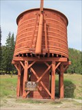 view gallery view gallerySW17.5 km |  Bakers Tank, Mile Post 102.16 - Boreas Pass Road, Summit County, Colorado Bakers Tank, Mile Post 102.16 - Boreas Pass Road, Summit County, Colorado
in Water Towers This is a restored railroad water tank. Between 1884 and 1937, locomotives of the Colorado and Southern line used this tank to refill the boilers of steam locomotives traversing this line. posted by: adenium location: Colorado date approved: 09/18/2010 last visited: 06/29/2016 |
|