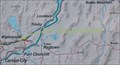
 view gallery view gallery N11.7 km N11.7 km
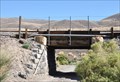
|   Wooden Railroad Overcrossing ~ Near Fernley, Nevada Wooden Railroad Overcrossing ~ Near Fernley, Nevada
in Railroad Bridges This short heavy wood-beam bridge carries the Union Pacific mainline across a gravel access road about 10 1/2 miles west of Fernley, Nevada. posted by:  brwhiz brwhiz location: Nevada date approved: 12/05/2012 last visited: never |
 view gallery view gallery NW11.7 km NW11.7 km
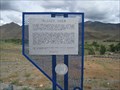
|  Truckee River - East Truckee River - East
in Nevada Historical Markers Located in a scenic viewpoint just off I-80, east of Reno, Nevada. posted by: lazyCachers location: Nevada date approved: 06/01/2008 last visited: 09/21/2014 |
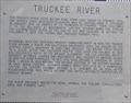 view gallery view galleryNW11.7 km |  First Recorded Discovery of Truckee River First Recorded Discovery of Truckee River
in First of its Kind The first recorded discovery of the Truckee River was by Captain John C. Frémont in 1844. posted by: brwhiz location: Nevada date approved: 10/10/2012 last visited: never |
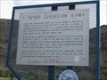
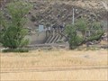 view gallery view galleryN11.7 km |  Derby Diversion Dam - Washoe County Derby Diversion Dam - Washoe County
in Water Dams Located just off I80 just west of Fernley, Nevada.
posted by: lazyCachers location: Nevada date approved: 06/08/2008 last visited: 06/09/2008 |
 view gallery view galleryN11.7 km | Derby Diversion Dam in Nevada Historical Markers Located just off I80 just west of Fernley, Nevada. posted by: lazyCachers location: Nevada date approved: 06/08/2008 last visited: 09/21/2014 |
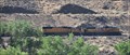
 view gallery view gallery NE14.6 km NE14.6 km
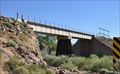
| Union Pacific Box-Girder Bridge - Painted Rock Rd Sparks, NV in Railroad Bridges This two-section box-girder bridge carries the Union Pacific mainline across the Truckee River below the Derby Diversion Dam, about 6 miles west of Fernley, Nevada. posted by: brwhiz location: Nevada date approved: 12/05/2012 last visited: never |
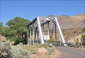 view gallery view galleryNE14.6 km |  Lincoln Highway Through-Truss Bridge Lincoln Highway Through-Truss Bridge
in Truss Bridges This one-lane Through-Truss Bridge carries an old alignment of the Lincoln Highway across the Truckee River about six miles west of Fernley, Nevada. posted by: brwhiz location: Nevada date approved: 12/03/2012 last visited: never |
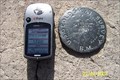 view gallery view galleryNE15.9 km |  "Unmarked" benchmark "Unmarked" benchmark
in U.S. Benchmarks This "blank" benchmark has no information stamped into it other than the generic USGS text. posted by: Nitro929 location: Nevada date approved: 05/20/2007 last visited: never |
 view gallery view gallery SE15.9 km SE15.9 km
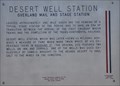
| Desert Well Station (Overland Mail and Stage Station) in Nevada Historical Markers Nevada State Historical Marker No. 177 is located on the south side of US Highway 50 California Emigrant Trail) at Palomino Street. posted by: brwhiz location: Nevada date approved: 09/10/2012 last visited: 08/03/2023 |
 view gallery view galleryNE17.2 km | Emigrant Trail Truckee River Route in Nevada Historical Markers Emigrant Trail Truckee River Route BLM Marker posted by: azayzel location: Nevada date approved: 07/31/2010 last visited: 07/28/2012 |
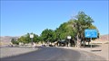 view gallery view galleryNE17.2 km |  Wadsworth Interstate 80 Westbound Rest Area Wadsworth Interstate 80 Westbound Rest Area
in Highway Rest Areas This Rest Area is located on the north side of Interstate Highway 80 about four miles west of Fernley, Nevada. posted by: brwhiz location: Nevada date approved: 12/03/2012 last visited: 08/24/2012 |
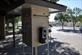 view gallery view galleryNE17.2 km |  Wadsworth Interstate 80 Westbound Rest Area Payphone Wadsworth Interstate 80 Westbound Rest Area Payphone
in Payphones This Payphone is located in the Wadsworth Rest Area on the north side of Interstate Highway 80 about four miles west of Fernley, Nevada. posted by: brwhiz location: Nevada date approved: 12/02/2012 last visited: never |
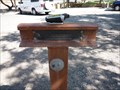
 view gallery view galleryNE17.2 km |  Wadsworth California Trail Marker Wadsworth California Trail Marker
in 'You Are Here' Maps You Are Here at the Wadsworth California Trail Marker in the Wadsworth Interstate 80 Westbound Rest Area on the north side of Interstate Highway 80 about four miles west of Fernley, Nevada. posted by: brwhiz location: Nevada date approved: 12/02/2012 last visited: never |
 view gallery view galleryNE17.4 km |  Wadsworth Rest Area Wadsworth Rest Area
in Active Rail Locations You can catch a lot of Union Pacific mainline action from the Wadsworth Rest Areas on either side of Interstate Highway 80 about four miles west of Fernley, Nevada. posted by: brwhiz location: Nevada date approved: 12/07/2012 last visited: never |
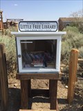 view gallery view gallery S19 km S19 km
|  Republic Of Molossia - Little Free Library Republic Of Molossia - Little Free Library
in Free Community Book Exchanges Located at 226 Mary Lane Road, Dayton, NV 89403. posted by: CharlyBaltimore location: Nevada date approved: 09/16/2017 last visited: 09/16/2017 |
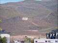 view gallery view gallery W20.6 km W20.6 km
|  S on Hill - Sparks , Nevada S on Hill - Sparks , Nevada
in Letters on Hills This Large S on the Hillside stands for Sparks Nevada. posted by:  GT.US GT.US location: Nevada date approved: 05/05/2010 last visited: 09/17/2011 |
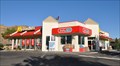
 view gallery view galleryW20.8 km |  McDonald's Brierley Way Free WiFi ~ Sparks, Nevada McDonald's Brierley Way Free WiFi ~ Sparks, Nevada
in Wi-Fi Hotspots Free WiFi Served Daily at the McDonald's at 2095 Brierley Way in Sparks, Nevada. posted by: brwhiz location: Nevada date approved: 11/23/2012 last visited: never |
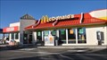
 view gallery view galleryW20.8 km |  McDonalds Brierley Way ~ Sparks, Nevada McDonalds Brierley Way ~ Sparks, Nevada
in McDonald's Restaurants This McDonalds is located at 2095 Brierley Way in Sparks, Nevada. posted by: brwhiz location: Nevada date approved: 12/01/2012 last visited: never |
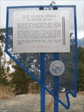 view gallery view gallery SW21.2 km SW21.2 km
| Old Geiger Grade - Virginia City, NV in Nevada Historical Markers This historical marker is located near Geiger Summit, between Reno and Virginia City, Nevada, along State Road 341. posted by: Chasing Blue Sky location: Nevada date approved: 05/03/2012 last visited: 08/30/2014 |
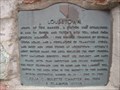 view gallery view gallerySW21.4 km | Lousetown - Virginia City, Nevada in Nevada Historical Markers In 1860, the uniquely named, Lousetown, was established as a toll road station, north of Viriginia City, Nevada. posted by: Chasing Blue Sky location: Nevada date approved: 05/03/2012 last visited: 08/30/2014 |
 view gallery view gallerySW21.4 km |  Lousetown, NV Lousetown, NV
in Ghost Towns In 1860, the uniquely named, Lousetown, was established as a toll road station, north of Viriginia City, Nevada. Before 1880, it was abandoned. posted by: Chasing Blue Sky location: Nevada date approved: 04/09/2012 last visited: 07/04/2016 |
 view gallery view gallerySW21.4 km | FIRST - Ice Project - Lousetown, NV in First of its Kind In 1860, the uniquely named, Lousetown, was established as a toll road station, north of Viriginia City, Nevada. This marker list a number of area firsts. posted by: Chasing Blue Sky location: Nevada date approved: 04/09/2012 last visited: 10/15/2010 |
 view gallery view gallerySW21.4 km | FIRST - Telegraph Line to Reno - Lousetown, NV in First of its Kind In 1860, the uniquely named, Lousetown, was established as a toll road station, north of Viriginia City, Nevada. This marker list a number of area firsts. posted by: Chasing Blue Sky location: Nevada date approved: 04/09/2012 last visited: 10/15/2010 |
 view gallery view gallerySW21.4 km |  Lousetown - Virginia City, Nevada Lousetown - Virginia City, Nevada
in E Clampus Vitus Historical Markers In 1860, the uniquely named, Lousetown, was established as a toll road station, north of Viriginia City, Nevada. posted by: Chasing Blue Sky location: Nevada date approved: 04/09/2012 last visited: 06/01/2014 |
 view gallery view gallerySW21.4 km | FIRST - Virginia City Railroad Surveys - Lousetown, NV in First of its Kind In 1860, the uniquely named, Lousetown, was established as a toll road station, north of Viriginia City, Nevada. This marker list a number of area firsts. posted by: Chasing Blue Sky location: Nevada date approved: 04/09/2012 last visited: 10/15/2010 |
|