 view gallery view gallery N0 km N0 km
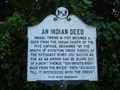
|   An Indian Deed An Indian Deed
in Maryland Historical Markers The historical marker titled "An Indian Deed" is located on Harpers Ferry Road near Limekiln Road in Antietam, Maryland. The marker is located on the south side of the bridge over Antietam Creek. posted by:  Marine Biologist Marine Biologist location: Maryland date approved: 08/20/2008 last visited: 02/23/2014 |
 view gallery view gallery E0.2 km E0.2 km
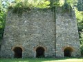
|  Antietam Iron Furnace - Sharpsburg, MD Antietam Iron Furnace - Sharpsburg, MD
in Ovens and Kilns The remains of the Antietam Iron Works are located along Antietam Creek in Sharpsburg, Maryland, USA. posted by: Marine Biologist location: Maryland date approved: 03/05/2011 last visited: 02/22/2014 |
 view gallery view galleryE0.2 km |  Antietam Iron Furnace - Sharpsburg, MD Antietam Iron Furnace - Sharpsburg, MD
in Iron Furnace Ruins The remains of the Antietam Iron Works are located along Antietam Creek in Sharpsburg, Maryland, USA. posted by: Marine Biologist location: Maryland date approved: 08/11/2008 last visited: 02/22/2014 |
 view gallery view galleryE0.2 km |  Antietam Iron Furnace Site and Antietam Village - Sharpsburg, MD Antietam Iron Furnace Site and Antietam Village - Sharpsburg, MD
in U.S. National Register of Historic Places The Antietam Iron Furnace Site and Antietam Village is a historic district located in Sharpsburg, Maryland. It consists of the remains of a mid-18th to late-19th century iron furnace site and the nearby related village. posted by: Marine Biologist location: Maryland date approved: 08/21/2008 last visited: 02/22/2014 |
 view gallery view gallery NW0.3 km NW0.3 km
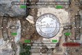
|  Antietam Aquaduct Antietam Aquaduct
in U.S. Benchmarks Benchmark in stone construction of the Antietam Aquaduct posted by: Red Starred location: Maryland date approved: 07/06/2012 last visited: 02/23/2014 |
 view gallery view gallery SW2.9 km SW2.9 km
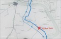
|  You Are Here - Moler Crossroads, A.P. Hill's March Sign - Shepardstown, WV You Are Here - Moler Crossroads, A.P. Hill's March Sign - Shepardstown, WV
in 'You Are Here' Maps This map is on an historical sign at a rural intersection by a small church. posted by: NorStar location: West Virginia date approved: 04/06/2015 last visited: never |
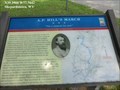 view gallery view gallerySW2.9 km |  A.P. Hill’s March “Not a moment too soon” - Harpers Ferry WV A.P. Hill’s March “Not a moment too soon” - Harpers Ferry WV
in U.S. Civil War Sites Gen. A.P. Hill division arrived on the battlefield less than eight hours after leaving Harpers Ferry, just in time to be thrown into the fight. When Hill reported, Lee exclaimed, “General Hill, I was never so glad to see you.” posted by:  Don.Morfe Don.Morfe location: West Virginia date approved: 05/05/2023 last visited: 05/06/2023 |
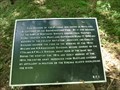
 view gallery view gallerySW2.9 km | A.P. Hill’s March “Not a moment too soon” - Bakerton WV in Civil War Discovery Trail Sites About two o’clock in the afternoon of September 17, 1862, Confederate Gen. A.P. Hill’s 3,000-man division began crossing the Potomac River at Boteler’s Ford posted by: Don.Morfe location: West Virginia date approved: 09/01/2020 last visited: 10/04/2021 |
 view gallery view gallery W3.4 km W3.4 km
| Boteler’s Ford Tablet B. F. 1. - Shepherdstown WV in U.S. Civil War Sites Marker is at the intersection of River Road (County Route 17/1) and Trough Road (County Route 31/1) near Shepherdstown, West Virginia, in Jefferson County. posted by: Don.Morfe location: West Virginia date approved: 01/30/2024 last visited: 01/30/2024 |
 view gallery view galleryW3.4 km |  Boteler’s Ford Tablet B. F. 1. - Shepherdstown WV Boteler’s Ford Tablet B. F. 1. - Shepherdstown WV
in Signs of History Marker is at the intersection of River Road (County Route 17/1) and Trough Road (County Route 31/1) near Shepherdstown, West Virginia, in Jefferson County. posted by: Don.Morfe location: West Virginia date approved: 01/30/2024 last visited: 01/30/2024 |
 view gallery view galleryW3.4 km | Boteler’s Ford Tablet B. F. 1. - Shepherdstown WV in American Civil War Monuments and Memorials Marker is at the intersection of River Road (County Route 17/1) and Trough Road (County Route 31/1) near Shepherdstown, West Virginia, in Jefferson County. posted by: Don.Morfe location: West Virginia date approved: 02/01/2024 last visited: 02/01/2024 |
 view gallery view galleryW3.4 km | Boteler’s Ford Tablet B. F. 3 - Shepherdstown WV in U.S. Civil War Sites Marker is at the intersection of River Road (County Route 17/1) and Trough Road (County Route 31/1) near Shepherdstown, West Virginia, in Jefferson County. posted by: Don.Morfe location: Maryland date approved: 01/30/2024 last visited: 01/30/2024 |
 view gallery view galleryW3.4 km | Boteler’s Ford Tablet B. F. 3 - Shepherdstown WV in Signs of History Marker is at the intersection of River Road (County Route 17/1) and Trough Road (County Route 31/1) near Shepherdstown, West Virginia, in Jefferson County. posted by: Don.Morfe location: Maryland date approved: 01/30/2024 last visited: 01/30/2024 |
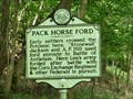
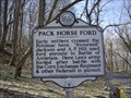 view gallery view galleryW3.4 km |  Pack Horse Ford Pack Horse Ford
in West Virginia Historical Markers Tells about different groups that used the area to cross the Potomac. posted by: Paintedwarrior location: West Virginia date approved: 03/25/2013 last visited: 11/05/2023 |
 view gallery view galleryW3.4 km | Pack Horse Ford - Shepherdstown, WV in American Civil War Monuments and Memorials The Pack Horse Ford marker is located on River Road, Shepherdstown WV. posted by: Don.Morfe location: West Virginia date approved: 11/19/2023 last visited: 11/19/2023 |
 view gallery view galleryN3.5 km | Battery E, 4th U.S. Artillery No 107 - Sharpsburg MD in Signs of History At daybreak Battery E, 4th U.S. Artillery, was in bivouac in rear of the high ground east of the Burnside Bridge. Soon after daybreak it took position on the ridge overlooking the Antietam posted by: Don.Morfe location: Maryland date approved: 09/25/2020 last visited: 11/02/2021 |
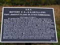 view gallery view galleryN3.5 km | U.S.A. Battery E, 4th U.S. Artillery No 107 - Sharpsburg MD in American Civil War Monuments and Memorials At daybreak Battery E, 4th U.S. Artillery, was in bivouac in rear of the high ground east of the Burnside Bridge. Soon after daybreak it took position on the ridge overlooking the Antietam. posted by: Don.Morfe location: Maryland date approved: 09/28/2022 last visited: 09/28/2022 |
 view gallery view galleryW3.5 km |  Cement Mill Ruins - Near Sheperdstown, WV Cement Mill Ruins - Near Sheperdstown, WV
in Preserved Architectural Remnants and Ruins Ruins of an old cement mill are found on either side of this windy country road. posted by: NorStar location: West Virginia date approved: 12/13/2014 last visited: never |
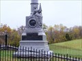 view gallery view galleryN3.7 km |  Official William McKinley Coffee Break Monument - Sharpsburg MD Official William McKinley Coffee Break Monument - Sharpsburg MD
in Roadside Attractions In 1903, two years after President McKinley had been assassinated, a group of Ohio Civil War veterans erected a 33-foot-tall pillar on the battlefield at Antietam near Sharpsburg, Maryland. posted by: Don.Morfe location: Maryland date approved: 01/18/2022 last visited: 02/12/2023 |
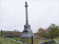 view gallery view galleryN3.7 km |  William McKinley Monument - Sharpsburg MD William McKinley Monument - Sharpsburg MD
in Specific Veteran Memorials Monument is in Antietam National Battlefield, Sharpsburg MD.
The inscription is: William McKinley January 29, 1843-September 14, 1901 Fourteen Years Member of Congress, Twice Governor of Ohio 1892-3 and 1894-5 posted by: Don.Morfe location: Maryland date approved: 06/03/2020 last visited: 07/20/2022 |
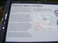 view gallery view galleryN3.9 km | Repulsed Again and Again - Sharpsburg MD in U.S. Civil War Sites Throughout the early hours of the battle, Confederate Gen. Lee moved soldiers from this part of his line north toward the Cornfield and the West Woods. posted by: Don.Morfe location: Maryland date approved: 09/25/2020 last visited: 11/02/2021 |
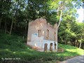
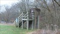 view gallery view galleryN3.9 km |  Antietam Creek Streamflow Gage House - Sharpsburg MD Antietam Creek Streamflow Gage House - Sharpsburg MD
in River Gauges Streamflow at Antietam Creek was first measured in 1897. This streamflow-gaging station was built in 1933. The nearby control dam was added in 1934. posted by: HaricotVert_52 location: Maryland date approved: 11/17/2009 last visited: 08/15/2011 |
 view gallery view galleryN3.9 km |  Burnside Bridge - Sharpsburg, Maryland Burnside Bridge - Sharpsburg, Maryland
in Arch Bridges The Burnside Bridge is located in the Antietam National Military Park near Sharpsburg, Maryland.
posted by: Sneakin Deacon location: Maryland date approved: 02/25/2008 last visited: 07/20/2022 |
 view gallery view galleryN3.9 km |  Burnside Bridge - Sharpsburg, Maryland Burnside Bridge - Sharpsburg, Maryland
in Stone Bridges The Burnside Bridge is located in the Antietam National Military Park near Sharpsburg, Maryland posted by: Sneakin Deacon location: Maryland date approved: 01/04/2007 last visited: 07/20/2022 |
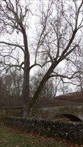 view gallery view galleryN3.9 km |  Burnside Bridge Witness Tree - Sharpsburg MD Burnside Bridge Witness Tree - Sharpsburg MD
in Historic Trees This stately sycamore still stands beside the Burnside Bridge on Antietam Battlefield and saw the battle action on that day in September 1862. posted by: HaricotVert_52 location: Maryland date approved: 11/18/2009 last visited: 07/20/2022 |
|