 view gallery view gallery W8 km W8 km
|   Tahoe National Forest, Island Lake Tahoe National Forest, Island Lake
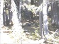
in Campgrounds Located in the Tahoe National Forest at 6885'
posted by:  BackPak BackPak location: California date approved: 11/04/2005 last visited: 08/24/2008 |
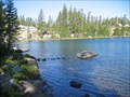 view gallery view galleryW8 km | Island Lake Tahoe National Forest, CA in Free Campsites FANTASTIC!! posted by: BackPak location: California date approved: 10/08/2007 last visited: 08/25/2008 |
 view gallery view gallery S8.4 km S8.4 km
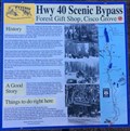
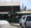
|  #3 - Forest Gift Shop, Cisco Grove - Cisco Grove, CA #3 - Forest Gift Shop, Cisco Grove - Cisco Grove, CA
in Signs of History History sign along the Hwy 40 Scenic Bypass. posted by: Volcanoguy location: California date approved: 06/21/2017 last visited: 10/09/2016 |
 view gallery view gallery E13.8 km E13.8 km
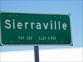
|  Sierraville CA pop. 350 Sierraville CA pop. 350
in Population Signs Hay and cattle country. The largest, high elevation valley in the Sierra mountains. 4,950 ft. posted by:  sbcamper sbcamper location: California date approved: 07/12/2016 last visited: never |
 view gallery view gallery SE14.3 km SE14.3 km
|  Soda Springs, CA - 95728 Soda Springs, CA - 95728
in U.S. Post Offices A small post office in Soda Springs, CA. posted by: saopaulo1 location: California date approved: 05/18/2011 last visited: never |
 view gallery view gallery SW15 km SW15 km
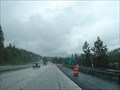
|  Emigrant Gap Emigrant Gap
in Wikipedia Entries Emigrant Gap is a gap in the Sierra Nevada mountain range and is located near the town of Emigrant Gap, California, USA. posted by: Marine Biologist location: California date approved: 06/03/2008 last visited: 09/12/2014 |
 view gallery view gallerySW15 km |  Emigrant Gap - Emigrant Gap, CA Emigrant Gap - Emigrant Gap, CA
in Named Mountain Gaps Emigrant Gap is a gap in the Sierra Nevada mountain range and is located near the town of Emigrant Gap, California, USA. posted by: Marine Biologist location: California date approved: 06/02/2008 last visited: 09/12/2014 |
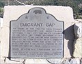 view gallery view gallerySW15.8 km |  Emigrant Gap Emigrant Gap
in California Historical Markers This marker stands at a hazardous location on the overland Emigrant Trail. posted by:  NevaP NevaP location: California date approved: 06/04/2007 last visited: 10/30/2011 |
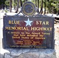
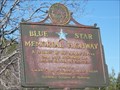 view gallery view gallerySW15.8 km |  I-80, westbound vista point, Emigrant Gap, CA I-80, westbound vista point, Emigrant Gap, CA
in Blue Star Memorial Highway Markers This marker is in a vista point pull off between exits 160 and 156 on westbound I-80. posted by: NevaP location: California date approved: 06/04/2007 last visited: never |
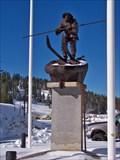 view gallery view galleryE16.1 km |  "Snowshoe" Thompson - Soda Springs CA "Snowshoe" Thompson - Soda Springs CA
in Statues of Historic Figures This statue was found just outside the Western America Skisport Museum
near Soda Springs, California. posted by: GT.US location: California date approved: 05/06/2010 last visited: never |
 view gallery view galleryE16.1 km |  Boreal Mountain Resort - Truckee, CA Boreal Mountain Resort - Truckee, CA
in Sledding Places Located off of I-80 in between Soda Springs and Truckee, CA. Coordinates are for the parking lot.
posted by: lazyCachers location: California date approved: 07/22/2008 last visited: 06/29/2011 |
 view gallery view galleryE16.1 km |  Boreal Mountain Resort - Truckee, CA Boreal Mountain Resort - Truckee, CA
in Winter Sports Locations Located off of I-80 in between Soda Springs and Truckee, CA. posted by: lazyCachers location: California date approved: 07/01/2008 last visited: 07/06/2011 |
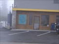 view gallery view gallerySW16.7 km | Emigrant Gap, CA 95715 in U.S. Post Offices A little store-front post office attached to a gas station and store posted by: WitzAbout location: California date approved: 06/12/2008 last visited: 07/04/2011 |
 view gallery view galleryE16.7 km | I-80 at Donner Pass, near Soda Springs, CA in Blue Star Memorial Highway Markers Donner Pass rest area has this marker on the east-bound lot posted by: ronjean location: California date approved: 05/23/2009 last visited: 03/10/2019 |
 view gallery view galleryE16.7 km |  Donner Summit - I80 - California Donner Summit - I80 - California
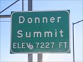
in Elevation Signs At 7227 feet above sea level, along I80 between Sacramento, CA and Reno, Nv. posted by: fishingwishing location: California date approved: 06/18/2008 last visited: 08/10/2014 |
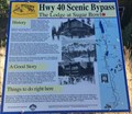 view gallery view gallerySE18 km | #21 - The Lodge at Sugar Bowl - Donner Pass, CA in Signs of History History sign along the Hwy 40 Scenic Bypass. posted by: Volcanoguy location: California date approved: 06/21/2017 last visited: 10/09/2016 |
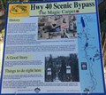 view gallery view gallerySE18 km | #20 - The Magic Carpet - Donner Pass, CA in Signs of History History sign along the Hwy 40 Scenic Bypass. posted by: Volcanoguy location: California date approved: 06/21/2017 last visited: 10/09/2016 |
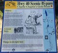 view gallery view gallerySE18 km | #19 - Charlie Chaplin’s Gold Rush - Donner Pass, CA in Signs of History History sign along the Hwy 40 Scenic Bypass. posted by: Volcanoguy location: California date approved: 06/21/2017 last visited: 10/09/2016 |
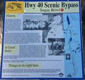 view gallery view gallerySE18 km | #18 - Sugar Bowl - Donner Pass, CA in Signs of History History sign along the Hwy 40 Scenic Bypass. posted by: Volcanoguy location: California date approved: 06/21/2017 last visited: 10/09/2016 |
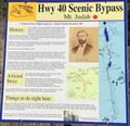 view gallery view gallerySE18.2 km | #__ - Mt. Judah - Donner Pass, CA in Signs of History #__ - Mt. Judah - Donner Pass, CA posted by: Volcanoguy location: California date approved: 06/21/2017 last visited: 10/09/2016 |
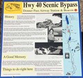 view gallery view gallerySE18.8 km | #25 - Donner Pass Airway Station & Beacon - Donner Pass, CA in Signs of History History sign along the Hwy 40 Scenic Bypass at Donner Summit Overlook. posted by: Volcanoguy location: California date approved: 06/19/2017 last visited: 10/09/2016 |
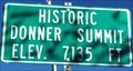 view gallery view gallerySE18.8 km | Historic Donner Summit - Elevation 7135 feet in Elevation Signs Elevation sign at Historic Donner Summit on U.S. Hwy. 50. posted by: Volcanoguy location: California date approved: 06/19/2017 last visited: 10/09/2016 |
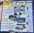 view gallery view gallerySE18.8 km | #26 - Sugar Bowl Academy - Donner Pass, CA in Signs of History History sign along the Hwy 40 Scenic Bypass at Donner Summit Overlook. posted by: Volcanoguy location: California date approved: 06/19/2017 last visited: 10/09/2016 |
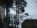
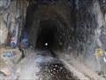 view gallery view gallerySE19.2 km |  Transcontinental Railroad Tunnel #6 - Donner Summit Transcontinental Railroad Tunnel #6 - Donner Summit
in Abandoned Train Tunnels The old Transcontinental Railroad Tunnel #6 at Donner Summit. posted by: Volcanoguy location: California date approved: 07/02/2017 last visited: 06/16/2019 |
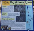 view gallery view gallerySE19.2 km | #31 - Petroglyphs - Donner Pass, CA in Signs of History History sign along the Hwy 40 Scenic Bypass. posted by: Volcanoguy location: California date approved: 06/17/2017 last visited: 10/09/2016 |
|