 view gallery view gallery SW5.5 km SW5.5 km
|   Van Meter State Park Overlook Van Meter State Park Overlook
in Scenic Overlooks Scenic overlook in Van Meter State Park located at end of a short trail with a trail head at the end of the park road. posted by:  BruceS BruceS location: Missouri date approved: 04/15/2007 last visited: never |
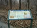 view gallery view gallerySW5.5 km |  Lewis and Clark Across Missouri - Van Meter State Park Lewis and Clark Across Missouri - Van Meter State Park
in Missouri Historical Markers Historical marker telling the story of the Lewis and Clark expedition in this area of Missouri. posted by: BruceS location: Missouri date approved: 04/15/2007 last visited: never |
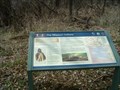 view gallery view gallerySW5.6 km | The Missouri Indians - Van Meter State Park in Missouri Historical Markers Historical marker commemorating the Missouri Indians located in Van Meter State Mark near Marshall, Missouri. posted by: BruceS location: Missouri date approved: 04/15/2007 last visited: never |
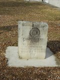
 view gallery view gallerySW5.8 km |  Utz Site - Van Meter State Park - Marshall, Missouri Utz Site - Van Meter State Park - Marshall, Missouri
in U.S. National Register of Historic Places Prehistoric Missouri Indian village site at Van Meter State Park near Marshall, Missouri. posted by: BruceS location: Missouri date approved: 04/16/2007 last visited: never |
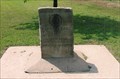
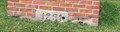
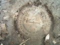 view gallery view gallerySW6 km |  UTZ -1928 - Van Meter State Park UTZ -1928 - Van Meter State Park
in U.S. Benchmarks Survey marker located near Indian burial mounds in Van Meter State Park. posted by: BruceS location: Missouri date approved: 04/15/2007 last visited: never |
 view gallery view gallerySW6.1 km |  Van Meter State Park Quonset Hut Van Meter State Park Quonset Hut
in Quonset Huts Quonset hut located on an old farmstead which has recently been acquired and is now part of Van Meter State Park near Marshall, Missouri. posted by: BruceS location: Missouri date approved: 04/15/2007 last visited: never |
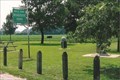
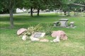
 view gallery view gallerySW6.1 km |  Van Meter State Park Burial Mounds - Marshall, Missouri Van Meter State Park Burial Mounds - Marshall, Missouri
in New World Ancient Evidence Indian mounds located in Van Meter State Park near Marshall, Missouri. posted by: BruceS location: Missouri date approved: 04/15/2007 last visited: never |
 view gallery view gallerySW6.4 km | Old Fort - Van Meter State Park - Missouri in U.S. National Register of Historic Places Historic Indian fort located at Van Meter State Park near Marshall, Missouri. posted by: BruceS location: Missouri date approved: 04/15/2007 last visited: never |
 view gallery view gallery N6.9 km N6.9 km
|  De Witt, MO. 64639 De Witt, MO. 64639
in U.S. Post Offices Very small town post office posted by:  YoSam. YoSam. location: Missouri date approved: 12/04/2014 last visited: never |
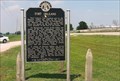
 view gallery view galleryN6.9 km |  Fort Orleans - near DeWitt, MO Fort Orleans - near DeWitt, MO
in Roadside Attractions Recently the markers have been moved to DeWitt Community Center Park. "The exact location of the fort is unknown; however, a marker is located on US Highway 24 in the Wiese Roadside Park about one mile northeast of De Witt, Missouri." ~ Legends posted by: YoSam. location: Missouri date approved: 02/09/2020 last visited: never |
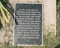
 view gallery view galleryN6.9 km |  First Settlement in Missouri made by the French - De Witt, Mo. First Settlement in Missouri made by the French - De Witt, Mo.
in First of its Kind This limestone marker is located in the City Park - 7th and Jefferson in De Witt, Mo. posted by: iconions location: Missouri date approved: 02/26/2014 last visited: 08/30/2014 |
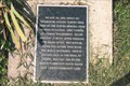
 view gallery view galleryN6.9 km |  Fort Orleans - De Witt, Mo. Fort Orleans - De Witt, Mo.
in Wikipedia Entries This limestone marker is located in the City Park - 7th and Jefferson in De Witt, Mo. posted by: iconions location: Missouri date approved: 02/27/2014 last visited: 08/30/2014 |
 view gallery view galleryN6.9 km | First Settlement in Missouri made by the French - De Witt, Mo. in Missouri Historical Markers This limestone marker is located in the City Park - 7th and Jefferson in De Witt, Mo. posted by: iconions location: Missouri date approved: 02/26/2014 last visited: 06/10/2008 |
 view gallery view galleryN6.9 km |  De Witt Bicentennial Flagpole - De Witt, Mo. De Witt Bicentennial Flagpole - De Witt, Mo.
in Spirit of '76 This flagpole has two bronze markers. The flagpole is on the southeast corner of the De Witt Community Center - 7th and Jefferson. posted by: iconions location: Missouri date approved: 02/28/2014 last visited: 08/31/2014 |
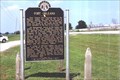
 view gallery view galleryN6.9 km |  Fort Orleans, Carroll County, Missouri Fort Orleans, Carroll County, Missouri
in Human Migration Monuments The French, and their contact with the natives of this land. posted by: YoSam. location: Missouri date approved: 03/24/2020 last visited: never |
![Image for FIRST - European [French] Post in Missouri Valley - DeWitt, MO](https://img.geocaching.com/waymarking/small/74ed8c3b-5211-40a0-9aca-09f45a06d9d9.jpg) view gallery view galleryN6.9 km | FIRST - European [French] Post in Missouri Valley - DeWitt, MO in First of its Kind The French, and their contact with the natives of this land. Also, First Catholic Church, first navigation maps of Missouri River, and first naming of the tribe of Indians now called "Misuri's" or Missuri's...extinct tribe, last member died in 1907 posted by: YoSam. location: Missouri date approved: 01/29/2020 last visited: never |
 view gallery view galleryN6.9 km |  Fort Orleans - DeWitt, MO, USA Fort Orleans - DeWitt, MO, USA
in Daughters of the American Revolution This limestone marker is located in the Community Park - 7th and Jefferson in De Witt, Mo. Originally this marker was in a roadside park about 1-1/2 miles N of here, on US-24. The entire roadside park has been removed by MoDot. posted by: YoSam. location: Missouri date approved: 11/25/2023 last visited: never |
 view gallery view galleryN6.9 km | Fort Orleans - DeWitt, MO in Missouri Historical Markers The French, and their contact with the natives of this land. posted by: YoSam. location: Missouri date approved: 03/22/2008 last visited: 02/22/2014 |
 view gallery view galleryN6.9 km | Potawatomi Camp - De Witt, MO in Missouri Historical Markers Traveled 10 miles this day, then camped here cold and wet. 23 Oct, 1838. posted by: YoSam. location: Missouri date approved: 06/22/2008 last visited: 02/22/2014 |
 view gallery view galleryN6.9 km |  Potawatomi Camp - De Witt, MO Potawatomi Camp - De Witt, MO
in Civil Rights Memorials Traveled 10 miles this day, then camped here cold and wet. 23 Oct, 1838. posted by: YoSam. location: Missouri date approved: 02/05/2020 last visited: never |
 view gallery view galleryN6.9 km |  Potawatomi Camp DeWitt, MO Potawatomi Camp DeWitt, MO
in Trail of Tears Oct. 23, 1838. Ferried the Grand River, traveled 10 miles then camped at Thomas' Encampment. posted by: YoSam. location: Missouri date approved: 06/25/2008 last visited: 02/22/2014 |
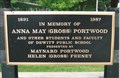 view gallery view galleryN6.9 km |  Anna May (Gross) Portwood - DeWitt, MO Anna May (Gross) Portwood - DeWitt, MO
in Citizen Memorials Born in De Witt in 1910 posted by: YoSam. location: Missouri date approved: 08/28/2014 last visited: never |
 view gallery view galleryN6.9 km |  1891 - De Witt Public School Building - De Witt, MO 1891 - De Witt Public School Building - De Witt, MO
in Dated Buildings and Cornerstones This town is now very, very small...city streets show on Google, but not many buildings left posted by: YoSam. location: Missouri date approved: 08/27/2014 last visited: never |
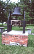 view gallery view galleryN6.9 km |  Dewitt School Bell - De Witt, MO Dewitt School Bell - De Witt, MO
in Bells Community center hold the memories, as town evolves from self sufficient to residential. posted by: YoSam. location: Missouri date approved: 11/06/2008 last visited: never |
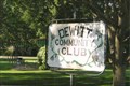 view gallery view galleryN6.9 km |  DeWitt Community Club - De Witt, MO DeWitt Community Club - De Witt, MO
in Municipal Community Centers I found this community center when I was searching for historic markers. posted by: YoSam. location: Missouri date approved: 12/01/2014 last visited: never |
|