 view gallery view gallery S1.3 km S1.3 km
|   Point of Rocks-Point of Rocks During the War - Point of Rocks MD Point of Rocks-Point of Rocks During the War - Point of Rocks MD
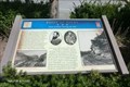
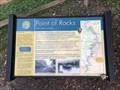
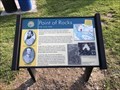
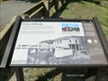
in Civil War Discovery Trail Sites The rail line immediately before you served as an important means of supply and communication during the Civil War (the station, and tracks to Washington, D.C., on the southern or right side of the station were built later). posted by:  Don.Morfe Don.Morfe location: Maryland date approved: 03/20/2020 last visited: 10/08/2021 |
 view gallery view galleryS1.3 km | Point of Rocks-Point of Rocks During the War - Point of Rocks MD in U.S. Civil War Sites In 1864, Confederate Lt. Col. John S. Mosby, in what became known as the “Calico Raid” or the “Crinoline Raid,” attacked the Union garrison here. posted by: Don.Morfe location: Maryland date approved: 03/27/2023 last visited: 04/02/2023 |
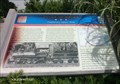 view gallery view galleryS1.3 km | Point of Rocks-Confederates Capture Train - Point of Rocks MD in Civil War Discovery Trail Sites In mid-June 1863, with rumors of a pending reinvasion of Maryland by Confederate forces, most Baltimore and Ohio trains stopped running past here. posted by: Don.Morfe location: Maryland date approved: 03/20/2020 last visited: 10/08/2021 |
 view gallery view galleryS1.3 km | Point of Rocks Confederates Capture Train - Point of Rocks MD in U.S. Civil War Sites In the predawn hours of June 17, 1863 Confederate cavalry crossed the Potomac River and attacked Union cavalry at nearby Catoctin Station, while another unit captured a military train here. posted by: Don.Morfe location: Maryland date approved: 03/27/2023 last visited: 04/02/2023 |
 view gallery view galleryS1.3 km |  Point of Rocks Station - Point of Rocks, Maryland Point of Rocks Station - Point of Rocks, Maryland
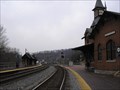
in Active Rail Locations The Point of Rocks Station is located between two CSX mainlines - the Metropolitan Branch and the Old Main Line. posted by:  Bluejacket01 Bluejacket01 location: Maryland date approved: 10/18/2009 last visited: 07/28/2022 |
 view gallery view galleryS1.3 km |  Point of Rocks station - Point of Rocks MD Point of Rocks station - Point of Rocks MD
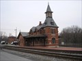
in Wikipedia Entries The station was built by the Baltimore and Ohio Railroad in 1873, and designed by E. Francis Baldwin. It is situated at the junction of the B&O Old Main Line (running to Baltimore) and the Metropolitan Branch (running to Washington, D.C.). posted by: Don.Morfe location: Maryland date approved: 10/23/2021 last visited: 04/02/2023 |
 view gallery view galleryS1.3 km |  Point of Rocks Railroad Station - Point of Rocks MD Point of Rocks Railroad Station - Point of Rocks MD
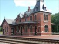
in U.S. National Register of Historic Places The Point of Rocks Railroad Station is a Gothic Revival building vaguely triangular in shape with a four-story tower on the apex and a 1 1/2-story wing at the base. The central 2 1/2-story section forms the main block of the station. posted by: Don.Morfe location: Maryland date approved: 10/24/2021 last visited: 04/02/2023 |
 view gallery view galleryS1.3 km |  Point of Rocks Station - Point of Rocks, Maryland Point of Rocks Station - Point of Rocks, Maryland
in Official Local Tourism Attractions Fine Victorian railroad station, late 1800s. Used today by MARC passenger trains. It was completed in 1876 and was designed by renowned architect E. Francis Baldwin who would construct a number of stations and depots for the B&O Railroad. posted by: Don.Morfe location: Maryland date approved: 07/28/2022 last visited: 04/02/2023 |
 view gallery view galleryS1.3 km |  Point of Rocks Station - Point of Rocks, Maryland Point of Rocks Station - Point of Rocks, Maryland
in Train Stations/Depots The Point of Rocks Station, one of the most photographed stations in the United States, was completed in 1876 as part of the construction of the Metropolitan Branch from Washington, DC. posted by: Bluejacket01 location: Maryland date approved: 02/02/2009 last visited: 12/17/2022 |
 view gallery view galleryS1.3 km |  1873 Train Station - Point of Rocks, MD 1873 Train Station - Point of Rocks, MD
in Philatelic Photographs Built in 1873 by the Baltimore & Ohio Railroad, the Point of Rocks train station was one of five historic stations to appear on a set of U.S. postage stamps in 2023. posted by: hykesj location: Maryland date approved: 06/21/2023 last visited: 05/23/2021 |
 view gallery view gallery SW1.3 km SW1.3 km
| Point of Rocks, Maryland in Wikipedia Entries Point of Rocks is an unincorporated community and census-designated place (CDP) in Frederick County, Maryland, United States. As of the 2010 census it had a population of 1,466. posted by: Don.Morfe location: Maryland date approved: 07/28/2022 last visited: 04/02/2023 |
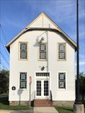 view gallery view gallerySW1.4 km |  Fervency Lodge No. 200 A.F.& A.M. - Point of Rocks, Maryland Fervency Lodge No. 200 A.F.& A.M. - Point of Rocks, Maryland
in Masonic Temples Located on the eastbound side of Clay Street prior to the train station. posted by: flyingmoose location: Maryland date approved: 10/13/2021 last visited: 04/02/2023 |
 view gallery view gallerySW1.4 km |  Flood Obelisk - Point of Rocks, Maryland Flood Obelisk - Point of Rocks, Maryland
in Obelisks Located within the Point of Rocks Community Commons Park. posted by: flyingmoose location: Maryland date approved: 10/11/2021 last visited: 04/02/2023 |
 view gallery view gallerySW1.4 km |  Flood Obelisk - Point of Rocks, Maryland Flood Obelisk - Point of Rocks, Maryland
in High Level Marks Located within the Point of Rocks Community Commons Park. posted by: flyingmoose location: Maryland date approved: 10/07/2021 last visited: 04/02/2023 |
 view gallery view gallerySW1.4 km |  The C&O Canal - Point of Rocks, Maryland The C&O Canal - Point of Rocks, Maryland
in Signs of History Located within the Point of Rocks Community Commons Park. posted by: flyingmoose location: Maryland date approved: 10/13/2021 last visited: 04/02/2023 |
 view gallery view gallerySW1.4 km |  Changes Over Time - Point of Rocks, Maryland Changes Over Time - Point of Rocks, Maryland
in Timelines Located within the Point of Rocks Community Commons Park. posted by: flyingmoose location: Maryland date approved: 10/13/2021 last visited: 04/02/2023 |
 view gallery view gallerySW1.4 km | Point of rocks in U.S. Civil War Sites Located within the Point of Rocks Community Commons Park. posted by: flyingmoose location: Virginia date approved: 10/13/2021 last visited: 04/02/2023 |
 view gallery view gallerySW1.4 km | ") C & O Canal Lock 28-Point of Rocks C & O Canal Lock 28-Point of Rocks
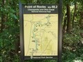
in National Parks (U.S.) Preserving America's early transportation history, the C&O Canal began as a dream of passage to Western wealth. Operating for nearly 100 years the canal was a lifeline for communities along the Potomac River. posted by: Don.Morfe location: Maryland date approved: 12/27/2019 last visited: 10/28/2021 |
 view gallery view gallerySW1.4 km |  Chesapeake and Ohio Canal National Historical Park-Lock 28 - Point of Rocks MD Chesapeake and Ohio Canal National Historical Park-Lock 28 - Point of Rocks MD
in National Parks of the World Point of Rocks, 14 miles south of Frederick, has for centuries been a transportation crossroads, starting with the Native Americans who used the area for major river crossings, lodging, and hunting. posted by: Don.Morfe location: Maryland date approved: 07/29/2022 last visited: 04/02/2023 |
 view gallery view gallerySW1.6 km | Point of Rocks Chesapeake and Ohio Canal National Historical Park - Point of Rocks MD in Signs of History In 1832, Point of Rocks served as the western terminus for the C&O Canal and the B&O Railroad. posted by: Don.Morfe location: Maryland date approved: 07/28/2022 last visited: 04/02/2023 |
 view gallery view gallerySW1.6 km |  C & O Canal Lockhouse 28-Point of Rocks C & O Canal Lockhouse 28-Point of Rocks
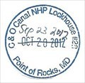
in NPS Passport Cancellation Stations Preserving America's early transportation history, the C&O Canal began as a dream of passage to Western wealth. Operating for nearly 100 years the canal was a lifeline for communities along the Potomac River. posted by: Don.Morfe location: Maryland date approved: 12/27/2019 last visited: 10/10/2021 |
 view gallery view gallery W1.6 km W1.6 km
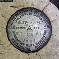
|  ET 156 AZ - C&O Canal Lock 28 Frederick County, Maryland ET 156 AZ - C&O Canal Lock 28 Frederick County, Maryland
in U.S. Benchmarks Located on top of canal lock stone work - no datasheet? posted by: macpurity location: Maryland date approved: 07/20/2007 last visited: 07/06/2013 |
 view gallery view gallerySW1.6 km |  Point of Rocks (US 15) Bridge - Point of Rocks, MD-VA Point of Rocks (US 15) Bridge - Point of Rocks, MD-VA
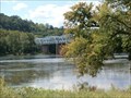
in Truss Bridges This camel truss bridge spans over the Potomac River at a landscape feature called Point of Rocks. posted by: NorStar location: Maryland date approved: 11/09/2014 last visited: 07/28/2022 |
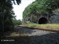 view gallery view gallerySW1.6 km |  Potomac River and Catoctin Mountain at Point of Rocks, MD Potomac River and Catoctin Mountain at Point of Rocks, MD
in Places of Geologic Significance At this location complex geological forces allowed the Potomac River to cut through the Catoctin Mountain, and the rock from this area was used to form the walls of the C&O Canal and the bed of the railroad tracks of the B&O Railroad. posted by: NorStar location: Maryland date approved: 11/12/2014 last visited: 07/29/2022 |
 view gallery view gallerySW1.6 km |  USGS 01638500 Potomac River at Point of Rocks, MD USGS 01638500 Potomac River at Point of Rocks, MD
in River Gauges This station is on the Maryland side of the Potomac River, a shallow and slow moving stream passing by a feature known as Point of Rocks. posted by: NorStar location: Maryland date approved: 11/04/2014 last visited: 07/29/2022 |
|