 view gallery view gallery NE0 km NE0 km
|   1862 Antietam Campaign Lee Invades Maryland - Dickerson MD 1862 Antietam Campaign Lee Invades Maryland - Dickerson MD
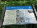
in Civil War Discovery Trail Sites Fresh from victory at the Second Battle of Manassas, Gen. Robert E. Lee’s Army of Northern Virginia crossed the Potomac River on September 4–6, 1862, to bring the Civil War to Northern soil and to recruit sympathetic Marylanders. posted by:  Don.Morfe Don.Morfe location: Maryland date approved: 03/20/2020 last visited: 10/08/2021 |
 view gallery view galleryNE0 km | Gettysburg Campaign Invasion & Retreat - Dickerson MD in Civil War Discovery Trail Sites After stunning victories at Fredericksburg and Chancellorsville, Virginia, early in May 1863, Confederate Gen. Robert E. Lee carried the war through Maryland, across the Mason and Dixon Line and into Pennsylvania. posted by: Don.Morfe location: Maryland date approved: 03/12/2020 last visited: 10/08/2021 |
 view gallery view gallery SE1.4 km SE1.4 km
|  Welcome to Frederick Co. Welcome to Frederick Co.
in Your Name Here This sign has my middle name, Frederick. posted by:  pseudoprime pseudoprime location: Maryland date approved: 11/09/2008 last visited: 04/15/2012 |
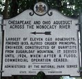 view gallery view gallerySE2.4 km |  Chesapeake and Ohio Aqueduct Across the Monocacy River Chesapeake and Ohio Aqueduct Across the Monocacy River
in Maryland Historical Markers Located at the intersection of route 28 and the Mouth of Monocacy Rd. This marker points down the road to the site of the largest of the 11 aqueducts along the C&O Canal. posted by: flyingmoose location: Maryland date approved: 09/01/2006 last visited: 06/28/2022 |
 view gallery view gallery SW2.4 km SW2.4 km
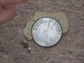
|  USDOI-GS AZDisk ET171, 1967, MD USDOI-GS AZDisk ET171, 1967, MD
in U.S. Benchmarks This Azimuth Marker is located on the NW corner of the Monocacy Aquaduct along the C&O canal. posted by: flyingmoose location: Maryland date approved: 02/27/2008 last visited: 04/15/2012 |
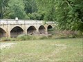
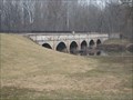
 view gallery view gallerySW2.4 km |  Monocacy Aqueduct - Dickerson MD Monocacy Aqueduct - Dickerson MD
in Wikipedia Entries The Monocacy Aqueduct — or C&O Canal Aqueduct No. 2 — is the largest aqueduct on the Chesapeake and Ohio Canal, crossing the Monocacy River just before it empties into the Potomac River in Frederick County. posted by: Don.Morfe location: Maryland date approved: 06/28/2022 last visited: 03/26/2023 |
 view gallery view gallerySW2.4 km |  Chesapeake and Ohio Canal National Historical Park- Monocacy Aqueduct - Dickerson MD Chesapeake and Ohio Canal National Historical Park- Monocacy Aqueduct - Dickerson MD
in Satellite Imagery Oddities The Monocacy Aqueduct — or C&O Canal Aqueduct No. 2 — is the largest aqueduct on the Chesapeake and Ohio Canal, crossing the Monocacy River just before it empties into the Potomac River in Frederick County, Maryland, USA. posted by: Don.Morfe location: Maryland date approved: 07/30/2022 last visited: 03/26/2023 |
 view gallery view gallerySW2.4 km | ") Chesapeake and Ohio Canal National Historical Park- Monocacy Aqueduct - Dickerson MD Chesapeake and Ohio Canal National Historical Park- Monocacy Aqueduct - Dickerson MD
in National Parks (U.S.) The Monocacy Aqueduct — or C&O Canal Aqueduct No. 2 — is the largest aqueduct on the Chesapeake and Ohio Canal, crossing the Monocacy River just before it empties into the Potomac River in Frederick County, Maryland, USA. posted by: Don.Morfe location: Maryland date approved: 08/02/2022 last visited: 03/26/2023 |
 view gallery view gallerySW2.4 km |  Chesapeake and Ohio Canal National Historical Park- Monocacy Aqueduct - Dickerson MD Chesapeake and Ohio Canal National Historical Park- Monocacy Aqueduct - Dickerson MD
in National Parks of the World The Monocacy Aqueduct — or C&O Canal Aqueduct No. 2 — is the largest aqueduct on the Chesapeake and Ohio Canal, crossing the Monocacy River just before it empties into the Potomac River in Frederick County, Maryland, USA. posted by: Don.Morfe location: Maryland date approved: 08/02/2022 last visited: 03/26/2023 |
 view gallery view gallerySW2.4 km |  Chesapeake and Ohio Canal National Historical Park- Monocacy Aqueduct - Dickerson MD Chesapeake and Ohio Canal National Historical Park- Monocacy Aqueduct - Dickerson MD
in Official Local Tourism Attractions The Monocacy Aqueduct — or C&O Canal Aqueduct No. 2 — is the largest aqueduct on the Chesapeake and Ohio Canal, crossing the Monocacy River just before it empties into the Potomac River in Frederick County, Maryland, USA. posted by: Don.Morfe location: Maryland date approved: 07/31/2022 last visited: 03/26/2023 |
 view gallery view gallerySW2.4 km |  LARGEST - Monocacy Aqueduct-Chesapeake and Ohio Canal - Dickerson MD - LARGEST - Monocacy Aqueduct-Chesapeake and Ohio Canal - Dickerson MD -
in Superlatives The Monocacy Aqueduct — or C&O Canal Aqueduct No. 2 — is the largest aqueduct on the Chesapeake and Ohio Canal, crossing the Monocacy River just before it empties into the Potomac River in Frederick County. posted by: Don.Morfe location: Maryland date approved: 06/28/2022 last visited: 03/26/2023 |
 view gallery view gallerySW2.4 km |  Monocacy Aqueduct Monocacy Aqueduct
in Stone Bridges This Stone aqueduct is not only the longest along the C&O Canal but easy to get to as well!
posted by: flyingmoose location: Maryland date approved: 04/06/2008 last visited: 06/28/2022 |
 view gallery view gallerySW2.4 km |  Monocacy Aqueduct Monocacy Aqueduct
in Ancient Aqueducts This aqueduct is not only the longest along the C&O Canal but easy to get to as well! posted by: flyingmoose location: Maryland date approved: 02/28/2008 last visited: 05/29/2022 |
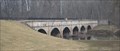 view gallery view gallerySW2.4 km |  Monocacy Aqueduct Monocacy Aqueduct
in Arch Bridges An Arched Aqueduct that has 7 arched spans. There is much storied history that extends well past the construction of this beauty. posted by: flyingmoose location: Maryland date approved: 03/01/2008 last visited: 06/28/2022 |
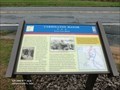
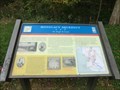 view gallery view gallerySW2.4 km | Monocacy Aqueduct Too Tough To Crack - Dickerson MD in U.S. Civil War Sites Confederate Gen. D. H. Hill’s division crossed the Potomac at Point of Rocks on September 4, 1862, and marched south to clear Union forces from the area. His men breached and drained the Chesapeake and Ohio Canal at several places. posted by: Don.Morfe location: Maryland date approved: 03/25/2023 last visited: 03/26/2023 |
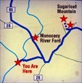 view gallery view gallerySW2.4 km |  You Are Here Map - Monocacy Aqueduct Too Tough To Crack - Dickerson MD You Are Here Map - Monocacy Aqueduct Too Tough To Crack - Dickerson MD
in 'You Are Here' Maps The You Are Here Map shows that you are near the Monocacy River Ford. posted by: Don.Morfe location: Maryland date approved: 03/25/2023 last visited: 03/26/2023 |
 view gallery view gallerySW2.6 km | Monocacy Aqueduct in Civil War Discovery Trail Sites Located along the C & O canal this is a well preserved site for all historians. posted by: flyingmoose location: Maryland date approved: 04/03/2008 last visited: 06/28/2022 |
 view gallery view gallery NW2.9 km NW2.9 km
| George Washington-The Dutchman's in Maryland Historical Markers George Washington-The Dutchman's-on his way to Frederick Friday, August 5, 1785 dined in a building on this site known as The Dutchman's posted by: Don.Morfe location: Maryland date approved: 10/28/2019 last visited: 09/28/2021 |
 view gallery view gallerySW3.2 km | Clapham's Ferry - Leesburg, Virginia in Wikipedia Entries Historic farm and ferry landing in rural Loudoun, Virginia. posted by:  BruceS BruceS location: Virginia date approved: 11/12/2013 last visited: 04/13/2014 |
 view gallery view gallerySW3.2 km |  Clapham's Ferry - Leesburg, Virginia Clapham's Ferry - Leesburg, Virginia
in U.S. National Register of Historic Places Historic farm and ferry landing in rural Loudoun, Virginia posted by: BruceS location: Virginia date approved: 11/14/2013 last visited: 04/13/2014 |
 view gallery view gallery E4 km E4 km
| Sugarloaf Mountain A Signalman’s Lot - Stronghold MD in Civil War Discovery Trail Sites You are at the foot of Sugarloaf Mountain, where on September 5-6, 1862, Union observers watched the Army of Northern Virginia cross the Potomac River to invade Maryland. posted by: Don.Morfe location: Maryland date approved: 03/22/2020 last visited: 10/08/2021 |
 view gallery view galleryE4 km | Sugarloaf Mountain A Signalman’s Lot - Dickerson MD in U.S. Civil War Sites You are at the foot of Sugarloaf Mountain, where on September 5-6, 1862, Union observers watched the Army of Northern Virginia cross the Potomac River to invade Maryland. posted by: Don.Morfe location: Maryland date approved: 03/28/2023 last visited: 04/02/2023 |
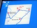 view gallery view galleryE4 km | You Are Here Map - Sugarloaf Mountain - Stronghold MD in 'You Are Here' Maps The You Are Here map shows that you are on Comus Road at the foot of Sugarloaf Mountain in Stronghold MD. The formal address is 7901 Comus Road, Dickerson MD 20842. posted by: Don.Morfe location: Maryland date approved: 03/28/2023 last visited: 04/02/2023 |
 view gallery view galleryNW4.7 km | Carrollton Manor-Green Corn March - Adamstown, MD in Civil War Discovery Trail Sites On Saturday, September 6, 1862, the Army of Northern Virginia was spread along the entire length of Buckeystown Turnpike all the way to Frederick. posted by: Don.Morfe location: Maryland date approved: 03/20/2020 last visited: 10/08/2021 |
 view gallery view galleryNW4.7 km | Carrollton Manor-Green Corn March - Adamstown MD in U.S. Civil War Sites On Saturday, September 6, 1862, the Army of Northern Virginia was spread along the entire length of Buckeystown Turnpike all the way to Frederick. The soldiers camped in the fields on either side of the road on the evenings of September 5-6. posted by: Don.Morfe location: Maryland date approved: 03/27/2023 last visited: 04/02/2023 |
|