 view gallery view gallery W0.3 km W0.3 km
|   Barnesville “… a bad night of it…” - Barnesville MD Barnesville “… a bad night of it…” - Barnesville MD
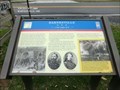
in U.S. Civil War Sites The advance of Union Gen. John F. Reynolds’ I Corps began slogging through Barnesville on the morning of Friday, June 26, 1863, having crossed the Potomac River the afternoon before and camped west of town. posted by:  Don.Morfe Don.Morfe location: Maryland date approved: 03/27/2023 last visited: 04/02/2023 |
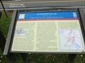 view gallery view galleryW0.3 km | Barnesville “Before night our town changed hands five times!” - Barnesville MD in Civil War Discovery Trail Sites On the evening of September 5, 1862, Gen. Wade Hampton’s and Gen. Fitzhugh Lee’s Confederate cavalry brigades bivouacked around Barnesville. posted by: Don.Morfe location: Maryland date approved: 03/22/2020 last visited: 10/08/2021 |
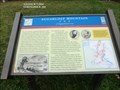
 view gallery view galleryW0.3 km | Barnesville “... a bad night of it...” - Barnesville, MD in Civil War Discovery Trail Sites The advance of Union Gen. John F. Reynolds’ I Corps began slogging through Barnesville on the morning of Friday, June 26, 1863, having crossed the Potomac River the afternoon before and camped west of town. posted by: Don.Morfe location: Maryland date approved: 03/22/2020 last visited: 10/08/2021 |
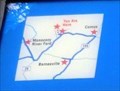
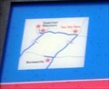
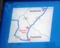
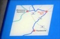 view gallery view galleryW0.3 km |  You Are Here Map - Barnesville “… a bad night of it…” - Barnesville MD You Are Here Map - Barnesville “… a bad night of it…” - Barnesville MD
in 'You Are Here' Maps The You Are Here Map shows that you are at the intersection of Barnesville Road and West Harris Road in Barnesville MD in the parking lot of the St. Mary’s Church. posted by: Don.Morfe location: Maryland date approved: 03/27/2023 last visited: 04/02/2023 |
 view gallery view gallery N3.7 km N3.7 km
| Sugarloaf Mountain A Signalman’s Lot - Dickerson MD in U.S. Civil War Sites You are at the foot of Sugarloaf Mountain, where on September 5-6, 1862, Union observers watched the Army of Northern Virginia cross the Potomac River to invade Maryland. posted by: Don.Morfe location: Maryland date approved: 03/28/2023 last visited: 04/02/2023 |
 view gallery view galleryN3.7 km | Sugarloaf Mountain A Signalman’s Lot - Stronghold MD in Civil War Discovery Trail Sites You are at the foot of Sugarloaf Mountain, where on September 5-6, 1862, Union observers watched the Army of Northern Virginia cross the Potomac River to invade Maryland. posted by: Don.Morfe location: Maryland date approved: 03/22/2020 last visited: 10/08/2021 |
 view gallery view galleryN3.7 km | You Are Here Map - Sugarloaf Mountain - Stronghold MD in 'You Are Here' Maps The You Are Here map shows that you are on Comus Road at the foot of Sugarloaf Mountain in Stronghold MD. The formal address is 7901 Comus Road, Dickerson MD 20842. posted by: Don.Morfe location: Maryland date approved: 03/28/2023 last visited: 04/02/2023 |
 view gallery view gallery NE3.9 km NE3.9 km
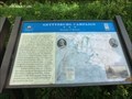
| Mt. Ephraim Crossroads Sharpshooters Hold the Line - Comus MD in U.S. Civil War Sites You are looking at Sugarloaf Mountain, where the running cavalry fight that began in the late afternoon on September 9, 1862, in Barnesville came to a halt. posted by: Don.Morfe location: Maryland date approved: 03/28/2023 last visited: 04/02/2023 |
 view gallery view galleryNE3.9 km | Mt. Ephraim Crossroads Sharpshooters Hold the Line - Dickerson, MD in Civil War Discovery Trail Sites You are looking at Sugarloaf Mountain, where the running cavalry fight that began in the late afternoon on September 9, 1862, in Barnesville came to a halt. posted by: Don.Morfe location: Maryland date approved: 03/27/2020 last visited: 10/08/2021 |
 view gallery view galleryNE3.9 km | Mt. Ephraim Crossroads - Comus MD in 'You Are Here' Maps You Are Hear map shows that you are at the foot of Sugarloaf Mountain on Comus Road. It is located in the rear of a parking lot for the Comus Inn at 23900 Old Hundred Rd, Dickerson MD 20842 posted by: Don.Morfe location: Maryland date approved: 03/28/2023 last visited: 04/02/2023 |
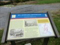
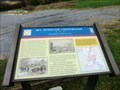 view gallery view galleryNE3.9 km |  Battle at Sugarloaf Mountain-Mt. Ephraim Crossroads Sharpshooters Hold the Line - Comus MD Battle at Sugarloaf Mountain-Mt. Ephraim Crossroads Sharpshooters Hold the Line - Comus MD
in Battlefields You are looking at Sugarloaf Mountain, where the running cavalry fight that began in the late afternoon on September 9, 1862, in Barnesville came to a halt. posted by: Don.Morfe location: Maryland date approved: 03/29/2023 last visited: 04/02/2023 |
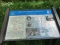
 view gallery view galleryNE3.9 km | 1862 Antietam Campaign Lee Invades Maryland- Dickerson MD in U.S. Civil War Sites Fresh from victory at the Second Battle of Manassas, Gen. Robert E. Lee’s Army of Northern Virginia crossed the Potomac River on September 4-6, 1862, to bring the Civil War to Northern soil and to recruit sympathetic Marylanders. posted by: Don.Morfe location: Maryland date approved: 03/28/2023 last visited: 04/02/2023 |
 view gallery view galleryNE3.9 km | 1862 Antietam Campaign Lee Invades Maryland - Dickerson MD in Civil War Discovery Trail Sites Fresh from victory at the Second Battle of Manassas, Gen. Robert E. Lee’s Army of Northern Virginia crossed the Potomac River on September 4-6, 1862, to bring the Civil War to Northern soil and to recruit sympathetic Marylanders. posted by: Don.Morfe location: Maryland date approved: 03/29/2020 last visited: 10/08/2021 |
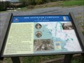
 view gallery view galleryW4.2 km |  Chesapeake and Ohio Aqueduct Across the Monocacy River Chesapeake and Ohio Aqueduct Across the Monocacy River
in Maryland Historical Markers Located at the intersection of route 28 and the Mouth of Monocacy Rd. This marker points down the road to the site of the largest of the 11 aqueducts along the C&O Canal. posted by:  flyingmoose flyingmoose location: Maryland date approved: 09/01/2006 last visited: 06/28/2022 |
 view gallery view galleryW4.8 km |  Welcome to Frederick Co. Welcome to Frederick Co.
in Your Name Here This sign has my middle name, Frederick. posted by: pseudoprime location: Maryland date approved: 11/09/2008 last visited: 04/15/2012 |
 view gallery view gallery SW5.1 km SW5.1 km
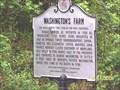
| WASHINGTON'S FARM in Maryland Historical Markers WASHINGTON'S FARM posted by: mrfixitman location: Maryland date approved: 05/14/2006 last visited: 04/15/2012 |
 view gallery view gallerySW5.5 km | Beallsville Squabble at the cemetery: Whose flag flies today? - Beallsville MD in Civil War Discovery Trail Sites On September 9, 1862, the running engagement between Illinois, Indiana, and Virginia cavalry units that began the day before in Poolesville continued in Beallsville when two Federal regiments forced the single regiment of Virginia cavalrymen posted here to flee to Barnesville. posted by: Don.Morfe location: Maryland date approved: 03/22/2020 last visited: 10/08/2021 |
 view gallery view gallerySW5.6 km | Beallsville Squabble at the cemetery: Whose flag flies today? - Beallsville MD in U.S. Civil War Sites On September 9, 1862, the running engagement between Illinois, Indiana, and Virginia cavalry units that began the day before in Poolesville continued in Beallsville. posted by: Don.Morfe location: Maryland date approved: 03/27/2023 last visited: 04/02/2023 |
 view gallery view gallerySW5.6 km | You Are Here Map - Beallsville Squabble at the cemetery: Whose flag flies today? - Beallsville MD in 'You Are Here' Maps You Are Here map shows that you are at the intersection of Beallsville Road (Maryland Route 109) and Darnestown Road (Maryland Route 28) in Beallsville MD posted by: Don.Morfe location: Maine date approved: 03/27/2023 last visited: 04/02/2023 |
 view gallery view gallery NW6 km NW6 km
| 1862 Antietam Campaign Lee Invades Maryland - Dickerson MD in Civil War Discovery Trail Sites Fresh from victory at the Second Battle of Manassas, Gen. Robert E. Lee’s Army of Northern Virginia crossed the Potomac River on September 4–6, 1862, to bring the Civil War to Northern soil and to recruit sympathetic Marylanders. posted by: Don.Morfe location: Maryland date approved: 03/20/2020 last visited: 10/08/2021 |
 view gallery view galleryNW6 km | Gettysburg Campaign Invasion & Retreat - Dickerson MD in Civil War Discovery Trail Sites After stunning victories at Fredericksburg and Chancellorsville, Virginia, early in May 1863, Confederate Gen. Robert E. Lee carried the war through Maryland, across the Mason and Dixon Line and into Pennsylvania. posted by: Don.Morfe location: Maryland date approved: 03/12/2020 last visited: 10/08/2021 |
 view gallery view galleryW6.3 km | Monocacy Aqueduct in Civil War Discovery Trail Sites Located along the C & O canal this is a well preserved site for all historians. posted by: flyingmoose location: Maryland date approved: 04/03/2008 last visited: 06/28/2022 |
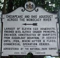
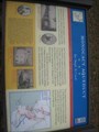
 view gallery view galleryW6.3 km | Monocacy Aqueduct Too Tough To Crack - Dickerson MD in U.S. Civil War Sites Confederate Gen. D. H. Hill’s division crossed the Potomac at Point of Rocks on September 4, 1862, and marched south to clear Union forces from the area. His men breached and drained the Chesapeake and Ohio Canal at several places. posted by: Don.Morfe location: Maryland date approved: 03/25/2023 last visited: 03/26/2023 |
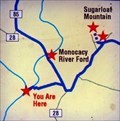 view gallery view galleryW6.3 km | You Are Here Map - Monocacy Aqueduct Too Tough To Crack - Dickerson MD in 'You Are Here' Maps The You Are Here Map shows that you are near the Monocacy River Ford. posted by: Don.Morfe location: Maryland date approved: 03/25/2023 last visited: 03/26/2023 |
 view gallery view galleryW6.4 km | ") Chesapeake and Ohio Canal National Historical Park- Monocacy Aqueduct - Dickerson MD Chesapeake and Ohio Canal National Historical Park- Monocacy Aqueduct - Dickerson MD
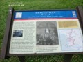
in National Parks (U.S.) The Monocacy Aqueduct — or C&O Canal Aqueduct No. 2 — is the largest aqueduct on the Chesapeake and Ohio Canal, crossing the Monocacy River just before it empties into the Potomac River in Frederick County, Maryland, USA. posted by: Don.Morfe location: Maryland date approved: 08/02/2022 last visited: 03/26/2023 |
|