 view gallery view gallery W3.1 km W3.1 km
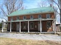
|   Sandy Springs Friends Meeting House - Sandy Springs MD Sandy Springs Friends Meeting House - Sandy Springs MD
in Quaker Meeting Houses Located in the heart of Sandy Spring is this wonderful meeting house. posted by:  flyingmoose flyingmoose location: Maryland date approved: 03/31/2008 last visited: 08/14/2009 |
 view gallery view gallery SW3.2 km SW3.2 km
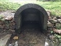
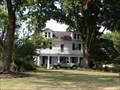
|  Sandy Spring - Sandy Spring, Maryland Sandy Spring - Sandy Spring, Maryland
in Natural Springs Located at the end of Meeting House Road. posted by: flyingmoose location: Maryland date approved: 08/21/2021 last visited: 10/11/2021 |
 view gallery view gallery NE3.7 km NE3.7 km
|  Four Stained Glass Windows on the side of St. Mark's Episcopal Church - Highland MD Four Stained Glass Windows on the side of St. Mark's Episcopal Church - Highland MD
in Stained Glass Windows There are four stained glass windows on the sides of the church. Also there are additional ones in the front of the church. The church was built in 1874. posted by:  Don.Morfe Don.Morfe location: Maryland date approved: 08/26/2021 last visited: 09/06/2021 |
 view gallery view galleryNE3.7 km |  St. Mark's Episcopal Church - Highland MD St. Mark's Episcopal Church - Highland MD
in This Old Church Founded in 1871, we are a parish church in the Episcopal Diocese of Maryland. Since 1874, our simple “rural gothic” white wainscoted church has served families, communities, and the larger world in service to God and his people. posted by: Don.Morfe location: Maryland date approved: 08/27/2021 last visited: 09/06/2021 |
 view gallery view galleryNE3.7 km |  St. Mark's Episcopal Church - Highland MD St. Mark's Episcopal Church - Highland MD
in Anglican and Episcopal Churches Founded in 1871, we are a parish church in the Episcopal Diocese of Maryland. Since 1874, our simple “rural gothic” white wainscoted church has served families, communities, and the larger world in service to God and his people. posted by: Don.Morfe location: Maryland date approved: 08/26/2021 last visited: 09/06/2021 |
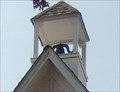 view gallery view galleryNE3.7 km |  Bell in steeple at St. Mark's Episcopal Church - Highland MD Bell in steeple at St. Mark's Episcopal Church - Highland MD
in Bell Towers A bell is in the steeple at St. Mark's Episcopal Church. The church was built in 1874. posted by: Don.Morfe location: Maryland date approved: 08/26/2021 last visited: 09/06/2021 |
 view gallery view galleryNE3.7 km |  Highland, Maryland Highland, Maryland
in Wikipedia Entries The GPS coordinates are for the U.S. Post Office in Highland, MD. Zip code 20777. Highland is an unincorporated community and census-designated place in Howard County, Maryland, United States. As of the 2020 census it had a population of 1,133. posted by: Don.Morfe location: Maryland date approved: 06/09/2024 last visited: 09/06/2021 |
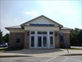 view gallery view galleryNE3.7 km |  Highland, Maryland 20777 Highland, Maryland 20777
in U.S. Post Offices 20777 is the Zip Code for Highland MD located in Howard County. The Post Office does not have a sign showing their name or Zip Code number. posted by: Don.Morfe location: Maryland date approved: 08/26/2021 last visited: 09/06/2021 |
 view gallery view galleryNE4.2 km | Fulton, Maryland in Wikipedia Entries The GPS coordinates are for Wheatland Farm, NRHP, located in Fulton, MD. Fulton is a census-designated place located in southern Howard County, Maryland, United States. As of the 2010 census it had a population of 2,049. posted by: Don.Morfe location: Maryland date approved: 06/09/2024 last visited: 09/06/2021 |
 view gallery view galleryNE4.2 km |  Wheatland - Fulton MD Wheatland - Fulton MD
in U.S. National Register of Historic Places "Bleakwood Farm," or "Wheatland Farm," was the property of the Adams family of Anne Arundel County through much of the first half of the nineteenth century, and at that time was a farm of 254 acres. posted by: Don.Morfe location: Maryland date approved: 07/26/2021 last visited: 09/06/2021 |
 view gallery view gallery N4.2 km N4.2 km
|  B.M. MM - W.S.S.C Survey Marker - Brighton Dam, Maryland B.M. MM - W.S.S.C Survey Marker - Brighton Dam, Maryland
in U.S. Benchmarks This is a WSSC benchmark on the Brighton Dam on the Patuxent River. posted by: Cacher_Alec location: Maryland date approved: 05/06/2024 last visited: 05/09/2024 |
 view gallery view galleryN4.2 km | B.M. M5 - W.S.S.C Survey Marker - Brighton Dam, Maryland in U.S. Benchmarks This is a WSSC benchmark on the Brighton Dam on the Patuxent River. posted by: Cacher_Alec location: Maryland date approved: 05/06/2024 last visited: 05/09/2024 |
 view gallery view galleryN4.2 km | B.M. M9 - W.S.S.C Survey Marker - Brighton Dam, Maryland in U.S. Benchmarks This is a WSSC benchmark on the Brighton Dam on the Patuxent River. posted by: Cacher_Alec location: Maryland date approved: 05/06/2024 last visited: 05/09/2024 |
 view gallery view galleryN4.2 km | B.M. M13 - W.S.S.C Survey Marker - Brighton Dam, Maryland in U.S. Benchmarks This is a WSSC benchmark on the Brighton Dam on the Patuxent River. posted by: Cacher_Alec location: Maryland date approved: 05/06/2024 last visited: 05/09/2024 |
 view gallery view galleryN4.2 km |  Brighton Dam - Brookeville, Maryland, USA Brighton Dam - Brookeville, Maryland, USA
in Water Dams This is Brighton Dam, a WSSC water dam in Brookeville, Maryland. posted by: Cacher_Alec location: Maryland date approved: 05/03/2024 last visited: 05/09/2024 |
 view gallery view galleryN4.2 km |  Brighton Dam Water Level Indicator - Brookeville, Maryland Brighton Dam Water Level Indicator - Brookeville, Maryland
in River Gauges This is the water level indicator at Brighton Dam and the Triadelphia Reservoir on the Patuxent River in Brookeville, Maryland. posted by: Cacher_Alec location: Maryland date approved: 05/06/2024 last visited: 05/09/2024 |
 view gallery view galleryN4.2 km | B.M. M15 - W.S.S.C Survey Marker - Brighton Dam, Maryland in U.S. Benchmarks This is a WSSC benchmark on the Brighton Dam on the Patuxent River. posted by: Cacher_Alec location: Maryland date approved: 05/06/2024 last visited: 05/09/2024 |
 view gallery view galleryN4.2 km | B.M. M17 - W.S.S.C Survey Marker - Brighton Dam, Maryland in U.S. Benchmarks This is a WSSC benchmark on the Brighton Dam on the Patuxent River. posted by: Cacher_Alec location: Maryland date approved: 05/06/2024 last visited: 05/09/2024 |
 view gallery view galleryN4.2 km | B.M. M19 - W.S.S.C Survey Marker - Brighton Dam, Maryland in U.S. Benchmarks This is a WSSC benchmark on the Brighton Dam on the Patuxent River. posted by: Cacher_Alec location: Maryland date approved: 05/06/2024 last visited: 05/09/2024 |
 view gallery view galleryN4.2 km | B.M. M21 - W.S.S.C Survey Marker - Brighton Dam, Maryland in U.S. Benchmarks This is a WSSC benchmark on the Brighton Dam on the Patuxent River. posted by: Cacher_Alec location: Maryland date approved: 05/06/2024 last visited: 05/09/2024 |
 view gallery view galleryN4.2 km | B.M. M23 - W.S.S.C Survey Marker - Brighton Dam, Maryland in U.S. Benchmarks This is a WSSC benchmark on the Brighton Dam on the Patuxent River. posted by: Cacher_Alec location: Maryland date approved: 05/06/2024 last visited: 05/09/2024 |
 view gallery view galleryN4.2 km | B.M. M25 - W.S.S.C Survey Marker - Brighton Dam, Maryland in U.S. Benchmarks This is a WSSC benchmark on the Brighton Dam on the Patuxent River. posted by: Cacher_Alec location: Maryland date approved: 05/06/2024 last visited: 05/09/2024 |
 view gallery view galleryN4.2 km | B.M. M29 - W.S.S.C Survey Marker - Brighton Dam, Maryland in U.S. Benchmarks This is a WSSC benchmark on the Brighton Dam on the Patuxent River. posted by: Cacher_Alec location: Maryland date approved: 05/06/2024 last visited: 05/09/2024 |
 view gallery view gallery E4.2 km E4.2 km
| Mt. Zion United Methodist Church - Highland MD in This Old Church On July 10, 1862 we began our journey as a faith community. In August 1918 the cornerstone was laid for a new two story masonry church building at the same corner as the preceding building. posted by: Don.Morfe location: Maryland date approved: 02/19/2023 last visited: 02/20/2023 |
 view gallery view galleryE4.2 km |  Mt. Zion United Methodist Church - Highland MD Mt. Zion United Methodist Church - Highland MD
in Methodist Churches July 10, 1862: We begin our journey as a faith community with a deed for 1.1 acre plot at the corner of Brown's Bridge Road and the Laurel Road (now Rt. 216). August, 1918: The cornerstone was laid for a new two story masonry church building. posted by: Don.Morfe location: Maryland date approved: 08/27/2021 last visited: 02/20/2023 |
|