 view gallery view gallery SW3.7 km SW3.7 km
|   Fort Pleasant Fort Pleasant
in West Virginia Historical Markers A marker about a Revolutionary War fort. posted by:  Markerman62 Markerman62 location: West Virginia date approved: 03/14/2015 last visited: 03/20/2016 |
 view gallery view gallerySW3.7 km |  Old Fields, WV 26845 Old Fields, WV 26845
in U.S. Post Offices Old Fields WV 26845 Post Office posted by: dukemartin location: West Virginia date approved: 05/31/2012 last visited: never |
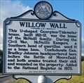 view gallery view gallerySW3.7 km | Willow Wall in West Virginia Historical Markers Home of McNeill family used during Civil War. posted by: dukemartin location: West Virginia date approved: 06/19/2022 last visited: never |
 view gallery view gallerySW4 km |  Battle of Moorefield-Where the Fighting Started - Old Fields WV Battle of Moorefield-Where the Fighting Started - Old Fields WV
in U.S. Civil War Sites Marker is at Old Fields, West Virginia, in Hardy County on U.S. 220. posted by:  Don.Morfe Don.Morfe location: West Virginia date approved: 07/11/2023 last visited: 07/11/2023 |
 view gallery view gallerySW4 km | Battle of Moorefield-Where the Fighting Started - Old Fields WV in Civil War Discovery Trail Sites The Confederate cavalry brigade of Gen. Bradley T. Johnson bivouacked in the fields to your left on August 7, 1864. Willow Wall (built ca. 1830), visible to your left down the road, was Johnson’s headquarters. posted by: Don.Morfe location: West Virginia date approved: 08/25/2020 last visited: 10/04/2021 |
 view gallery view gallery N6.9 km N6.9 km
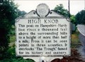
| High Knob in West Virginia Historical Markers A high peak along the county line between Hampshire and Hardy Counties. posted by: Markerman62 location: West Virginia date approved: 04/08/2015 last visited: 03/20/2016 |
 view gallery view gallerySW8.4 km | Battle of Moorefield-Running for the Hills - Moorefield WV in Civil War Discovery Trail Sites Confederate Gen. John McCausland's cavalry brigade was camped in the fields in front of you on this side of the South Branch of the Potomac River posted by: Don.Morfe location: West Virginia date approved: 08/25/2020 last visited: 10/04/2021 |
 view gallery view gallerySW8.4 km | Battle of Moorefield-Running for the Hills - Moorefield WV in U.S. Civil War Sites Marker is in Moorefield, West Virginia, in Hardy County at 596 Harness Rd, Moorefield WV 26836 posted by: Don.Morfe location: West Virginia date approved: 07/11/2023 last visited: 07/11/2023 |
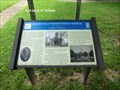
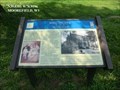
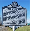 view gallery view gallerySW9 km | Battle of Moorefield in West Virginia Historical Markers A sign describing some the the civil war activities that took place here. posted by: dukemartin location: West Virginia date approved: 04/09/2018 last visited: 04/09/2018 |
 view gallery view gallerySW10 km | Moorefield, WV 26836 in U.S. Post Offices Moorefield WV 26836 Post Office posted by: dukemartin location: West Virginia date approved: 05/31/2012 last visited: never |
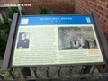
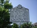 view gallery view gallerySW10.6 km | McNeill's Raid / Gen Joseph Neville in West Virginia Historical Markers Tells some of the raids that Mc Neill's Rangers went on and the grave site of General Joseph Neville. posted by: Paintedwarrior location: West Virginia date approved: 07/07/2012 last visited: 09/01/2004 |
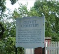 view gallery view gallerySW10.8 km | Olivet Cemetery - Moorefield WV in U.S. Civil War Sites Soldiers of both north and south buried here, battles took place on the cemetery and adjoining hill Jan. 3, 1863. posted by: Don.Morfe location: West Virginia date approved: 08/25/2020 last visited: 10/04/2021 |
 view gallery view gallery S10.8 km S10.8 km
| Cemetery Hill-Fighting Among the Tombstones - Moorefield WV in U.S. Civil War Sites Marker is in Moorefield, West Virginia, in Hardy County at 192 Olivet Drive, Moorefield WV 26836 in Olivet Cemetery. posted by: Don.Morfe location: West Virginia date approved: 07/11/2023 last visited: 07/11/2023 |
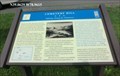
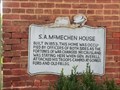 view gallery view gallerySW11.1 km | S. A. McMechen House - Moorefield WV in U.S. Civil War Sites This home was occupied by officers of both sides as the fortunes of war changed. posted by: Don.Morfe location: West Virginia date approved: 08/25/2020 last visited: 10/04/2021 |
 view gallery view gallerySW11.1 km | McMechen House-Confederate Headquarters - Moorefield WV 26836 in Civil War Discovery Trail Sites This house was constructed about 1853 for Samuel A. McMechen, merchant, father of five daughters and deacon of Moorefield Presbyterian Church up the street on your right. posted by: Don.Morfe location: West Virginia date approved: 08/25/2020 last visited: 10/04/2021 |
 view gallery view gallerySW11.1 km | McMechen House Confederate Headquarters - Moorefield WV in U.S. Civil War Sites Marker is in Moorefield, West Virginia, in Hardy County at 109 N Main St, Moorefield WV 26836. posted by: Don.Morfe location: West Virginia date approved: 07/11/2023 last visited: 07/11/2023 |
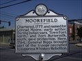 view gallery view gallerySW11.1 km | Moorefield in West Virginia Historical Markers Tells how Moorefield got its name. posted by: Paintedwarrior location: West Virginia date approved: 07/07/2012 last visited: 09/01/2004 |
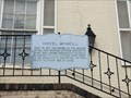 view gallery view gallerySW11.3 km | Hotel McNeill - Moorefield WV in U.S. Civil War Sites This building offered shelter to many well-known personages. posted by: Don.Morfe location: West Virginia date approved: 08/25/2020 last visited: 10/04/2021 |
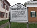 view gallery view gallerySW11.3 km | Presbyterian Church in West Virginia Historical Markers Tells the use of the church during he civil war. posted by: Paintedwarrior location: West Virginia date approved: 03/21/2016 last visited: 03/20/2016 |
 view gallery view gallerySW11.3 km | Moorefield Presbyterian Church-Confederate Sanctuary - Moorefield WV in U.S. Civil War Sites Marker is in Moorefield, West Virginia, in Hardy County at 109 South Main Street, Moorefield WV 26836. posted by: Don.Morfe location: West Virginia date approved: 07/11/2023 last visited: 07/11/2023 |
 view gallery view gallerySW11.3 km | Moorefield Presbyterian Church Confederate Sanctuary - Moorefield WV in Civil War Discovery Trail Sites The Rev. William V. Wilson, the minister, was an outspoken Confederate sympathizer as was his congregation, which was composed of Moorefield's prominent, wealthy residents. Many sons of the older congregants served in the county militia and in regular Confederate army units. posted by: Don.Morfe location: West Virginia date approved: 03/11/2020 last visited: 10/08/2021 |
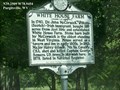 view gallery view galleryN11.3 km | White House Farm - Summit Point WV in West Virginia Historical Markers In 1740, Dr. John McCormick, a Scots (Scotch)-Irish immigrant bought 395 acres from Jost Hite and established White House Farm posted by: Don.Morfe location: West Virginia date approved: 03/12/2020 last visited: 10/24/2021 |
 view gallery view gallery NW11.7 km NW11.7 km
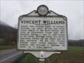
| Vincent Williams in West Virginia Historical Markers A sign telling us about the Native Americans attack on his home. posted by: Paintedwarrior location: West Virginia date approved: 03/21/2016 last visited: 03/20/2016 |
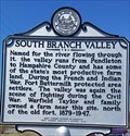 view gallery view gallerySW13.2 km | South Branch Valley in West Virginia Historical Markers A sign telling us about Fort Buttermilk. posted by: dukemartin location: West Virginia date approved: 04/09/2018 last visited: 04/09/2018 |
 view gallery view galleryS13.4 km | Mill Island-Confederate Hospital - Moorefield WV in U.S. Civil War Sites Marker is in Moorefield, West Virginia, in Hardy County on Mill Island Drive, Moorefield WV 26836 posted by: Don.Morfe location: West Virginia date approved: 07/11/2023 last visited: 07/11/2023 |
|