 view gallery view gallery SE1.4 km SE1.4 km
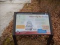
|   Observing the Enemy - Pasadena MD Observing the Enemy - Pasadena MD
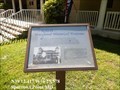
in Signs of History Marker is located at 2795 Bayside Beach Road, Pasadena, MD United States
21122. posted by:  Don.Morfe Don.Morfe location: Maryland date approved: 09/17/2023 last visited: 09/17/2023 |
 view gallery view gallerySE1.4 km |  Observing the Enemy - Pasadena MD Observing the Enemy - Pasadena MD
in Battlefields In 1814, British vessels combing the Chesapeake had a good view of the Bodkin, too. On August 24, a lookout on the HMS Menelaus spotted a "fine schooner," behind Bodkin Point. The Royal Marines reported they destroyed the Lion of Baltimore. posted by: Don.Morfe location: Maryland date approved: 09/17/2023 last visited: 09/17/2023 |
 view gallery view gallerySE1.4 km |  Observing the Enemy - Pasadena MD Observing the Enemy - Pasadena MD
in War of 1812 Local Militia Captain Francis Hancock, master of Hancock's Resolution Plantation, commanded a company in the 22nd Regiment, Maryland Militia. The company's duties included observation of enemy movements south of the mouth of the Patapsco. posted by: Don.Morfe location: Maryland date approved: 03/09/2022 last visited: 03/09/2022 |
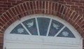
 view gallery view gallerySE1.6 km |  Hancock's Resolution - Pasadena MD Hancock's Resolution - Pasadena MD
in U.S. National Register of Historic Places Hancock's Resolution is architecturally significant as one of the few existing 18th century stone dwellings in Anne Arundel County. posted by: Don.Morfe location: Maryland date approved: 03/09/2022 last visited: 03/09/2022 |
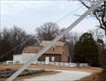 view gallery view gallerySE1.6 km |  Hancock's Resolution - Pasadena MD Hancock's Resolution - Pasadena MD
in Satellite Imagery Oddities Hancock's Resolution is a historic two-story gambrel-roofed stone farm house with shed-roofed dormers and interior end chimneys located on a 15-acre (6.1 ha) farm at 2795 Bayside Beach Road in Pasadena, Anne Arundel County, Maryland, United States. posted by: Don.Morfe location: Maryland date approved: 09/16/2023 last visited: 09/16/2023 |
 view gallery view gallerySE1.6 km |  Hancock's Resolution - Pasadena MD Hancock's Resolution - Pasadena MD
in Wikipedia Entries Hancock's Resolution is a historic two-story gambrel-roofed stone farm house with shed-roofed dormers and interior end chimneys located on a 15-acre (6.1 ha) farm at 2795 Bayside Beach Road in Pasadena, Anne Arundel County, Maryland, United States. posted by: Don.Morfe location: Maryland date approved: 03/08/2022 last visited: 03/09/2022 |
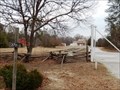 view gallery view gallerySE1.6 km |  Hancock's Resolution - Pasadena MD Hancock's Resolution - Pasadena MD
in Official Local Tourism Attractions Hancock's Resolution is a historic two-story gambrel-roofed stone farm house with shed-roofed dormers and interior end chimneys located on a 15-acre (6.1 ha) farm at 2795 Bayside Beach Road in Pasadena, Anne Arundel County, Maryland, United States. posted by: Don.Morfe location: Maryland date approved: 09/17/2023 last visited: 09/17/2023 |
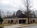 view gallery view gallery S3.9 km S3.9 km
|  Our Lady of the Chesapeake - Pasadena MD Our Lady of the Chesapeake - Pasadena MD
in Roman Catholic Churches The groundbreaking ceremony for the church building took place on October 14, 1984. On Sunday, March 16, 1986, William D. Borders, thirteenth Ordinary of the Archdiocese of Baltimore presided over the ancient rite of dedication of a church building. posted by: Don.Morfe location: Maryland date approved: 03/11/2022 last visited: 03/10/2022 |
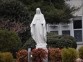 view gallery view gallery W5 km W5 km
|  St. Jane Frances de Chantal Statue - Pasadena MD St. Jane Frances de Chantal Statue - Pasadena MD
in Statues of Religious Figures The statue of St. Jane Frances de Chantal is on the grounds of St. Jane Frances de Chantal Catholic Church in Pasadena, Anne Arundel County, Maryland. posted by: Don.Morfe location: Maryland date approved: 03/10/2022 last visited: 03/10/2022 |
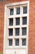 view gallery view galleryW5 km |  Stained Glass Windows on the side of St. Jane Frances de Chantal Catholic Church - Pasadena MD Stained Glass Windows on the side of St. Jane Frances de Chantal Catholic Church - Pasadena MD
in Stained Glass Windows There is a block of stained glass windows on the side of St. Jane Frances de Chantal Catholic Church. The church was organized in 1945 and the current church was built in 1960. posted by: Don.Morfe location: Maryland date approved: 03/10/2022 last visited: 03/10/2022 |
 view gallery view galleryW5 km |  1960 - St. Jane Frances de Chantal Catholic Church - Pasadena MD 1960 - St. Jane Frances de Chantal Catholic Church - Pasadena MD
in Dated Buildings and Cornerstones In September 2020, St. Jane Frances de Chantal Parish celebrated its 75th Anniversary! They were organized in 1945. The current church building has a cornerstone dated 1960. posted by: Don.Morfe location: Maryland date approved: 03/09/2022 last visited: 03/10/2022 |
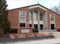 view gallery view galleryW5 km | St. Jane Frances de Chantal Catholic Church - Pasadena MD in Roman Catholic Churches In September 2020, St. Jane Frances de Chantal Parish celebrated its 75th Anniversary! They were organized in 1945. The current church building has a cornerstone dated 1960. posted by: Don.Morfe location: Maryland date approved: 03/11/2022 last visited: 03/10/2022 |
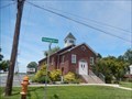
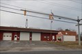 view gallery view gallery SW5.3 km SW5.3 km
|  Lake Shore Volunteer Fire Department Lake Shore Volunteer Fire Department
in Firehouses The Fire Company for formed in August 1944. The Fire Company building was started in 1945. The building was to contain: A large room for the engine, meeting room, kitchen, 2 restrooms and a large basement room. posted by: Don.Morfe location: Maryland date approved: 03/10/2022 last visited: 03/11/2022 |
 view gallery view gallery N5.8 km N5.8 km
|  Fort Howard Park, Blackberries, MD Fort Howard Park, Blackberries, MD
in Berry Picking A nice patch of blueberries located on top of an old military installation. posted by:  ODragon ODragon location: Maryland date approved: 07/16/2008 last visited: 04/26/2014 |
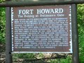 view gallery view galleryN6 km | Fort Howard The Bulldog at Baltimore's Gate Marker-Fort Howard, MD in Signs of History Fort Howard had its beginning when the U. S. Government began to purchase land for the post in 1896. posted by: Don.Morfe location: Maryland date approved: 10/07/2019 last visited: 09/28/2021 |
 view gallery view galleryN6 km |  Fort Howard-Fort Howard, MD Fort Howard-Fort Howard, MD
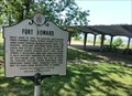
in Maryland Historical Markers Fort Howard was built here in 1896 to defend Baltimore from possible naval attack. Named for Col. John Eager Howard, Revolutionary hero. posted by: Don.Morfe location: Maryland date approved: 10/08/2019 last visited: 09/28/2021 |
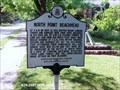 view gallery view galleryN6.4 km | North Point Beachhead-Fort Howard, MD in Maryland Historical Markers North Point Beachhead-At 3 a.m. on September 12, 1814, British began landing troops and supplies here from ships anchored in Old Road Bay. posted by: Don.Morfe location: Maryland date approved: 10/08/2019 last visited: 09/28/2021 |
 view gallery view galleryN7.1 km | Fort Howard, Maryland in Wikipedia Entries Fort Howard is an unincorporated community and census-designated place in Baltimore County. The GPS Coordinates are for the Fort Howard U.S. Post Office located at 9200 Fort Howard Ave, Fort Howard MD. 21052. posted by: Don.Morfe location: Maryland date approved: 12/02/2023 last visited: 07/15/2020 |
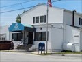
 view gallery view galleryN7.1 km |  Fort Howard, Maryland 21052 Fort Howard, Maryland 21052
in U.S. Post Offices This a small post office located on 9200 Fort Howard Ave, Fort Howard MD. 21052 posted by: Don.Morfe location: Maryland date approved: 07/20/2021 last visited: 08/28/2021 |
 view gallery view galleryN7.1 km | Stained Glass Window above the front door - Fort Howard Community Church - Fort Howard MD in Stained Glass Windows The stained Glass Window above the front door of the church. Fort Howard Community Church is a Gospel-Centered Ministry in Fort Howard, Maryland, located on North Point Peninsula in Baltimore County. posted by: Don.Morfe location: Maryland date approved: 07/20/2021 last visited: 08/28/2021 |
 view gallery view galleryN7.1 km |  Fort Howard Community Church - Fort Howard MD Fort Howard Community Church - Fort Howard MD
in Baptist Churches Fort Howard Community Church is a Gospel-Centered Ministry in Fort Howard, Maryland, located on North Point Peninsula in Baltimore County. We partner with the SBC and affirm The Baptist Faith and Message (2000). posted by: Don.Morfe location: Maryland date approved: 07/20/2021 last visited: 08/28/2021 |
 view gallery view galleryN7.2 km | The Landing Star-Spangled Banner National Historic Trail - Fort Howard MD in War of 1812 Transport ships carrying a British invasion force arrived in Old Road Bay, September 11, 1814. posted by: Don.Morfe location: Maryland date approved: 03/19/2020 last visited: 11/02/2021 |
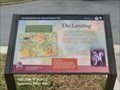 view gallery view galleryN7.2 km | The Landing Star-Spangled Banner National Historic Trail - Fort Howard MD in Signs of History Transport ships carrying a British invasion force arrived in Old Road Bay, September 11, 1814. posted by: Don.Morfe location: Maryland date approved: 09/01/2022 last visited: 01/16/2023 |
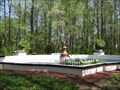 view gallery view galleryN7.2 km |  North Point State Park North Point State Park
in Fountains This fountain was built in the early 1900's as part of the Bayshore Amusment Park. posted by: stratus location: Maryland date approved: 04/20/2006 last visited: 04/26/2014 |
 view gallery view galleryN7.2 km | The Rebirth of a Maryland Historical Treasure - Sparrows Point, MD in Signs of History Originally built in 1906 by the United Railways and Electric Company on this site, stood the once grand Bay Shore Park Restaurant. posted by: Don.Morfe location: Maryland date approved: 01/19/2020 last visited: 09/25/2021 |
|