 view gallery view gallery N2.1 km N2.1 km
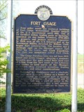
|   Fort Osage - Buckner, Mo. Fort Osage - Buckner, Mo.
in Missouri Historical Markers This marker is located at Heisler Park in Buckner, Mo. posted by:  iconions iconions location: Missouri date approved: 07/22/2012 last visited: 04/01/2012 |
 view gallery view gallery E5.8 km E5.8 km
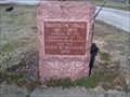
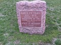
|  Santa Fe Trail Marker - Levasy Santa Fe Trail Marker - Levasy
in Wagon Roads and Trails Santa Fe Trail marker placed off of Old Lexington Road in Levasy. posted by:  betaylor73 betaylor73 location: Missouri date approved: 04/01/2009 last visited: 04/01/2012 |
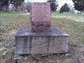 view gallery view galleryN6.6 km | Santa Fe Trail Marker - Fort Osage in Wagon Roads and Trails Santa Fe Trail marker placed near historic Fort Osage. posted by: betaylor73 location: Missouri date approved: 04/03/2009 last visited: 05/24/2009 |
 view gallery view galleryN6.9 km |  Fort Osage - Sibley, MO Fort Osage - Sibley, MO
in U.S. National Register of Historic Places Fort Osage (also known as Fort Clark or Fort Sibley) was an early 19th-century factory trading post run by the United States Government in western Missouri on the American frontier; it was located in present-day Sibley, Missouri. posted by: nomadwillie location: Missouri date approved: 02/26/2022 last visited: never |
 view gallery view galleryN6.9 km |  Fort Osage - Sibley, MO Fort Osage - Sibley, MO
in Historic Forts Fort Osage (also known as Fort Clark or Fort Sibley) was an early 19th-century factory trading post run by the United States Government in western Missouri on the American frontier; it was located in present-day Sibley, Missouri. posted by: nomadwillie location: Missouri date approved: 03/02/2022 last visited: never |
 view gallery view galleryN6.9 km |  Fort Osage - Sibley MO Fort Osage - Sibley MO
in Lewis and Clark Trail During their famous expedition up the Missouri River in seeking the Northwest Passage to the Pacific Ocean, Americans Meriwether Lewis and William Clark noted this spot in June 1804, as they camped for the night just across the river. posted by: nomadwillie location: Missouri date approved: 03/08/2022 last visited: never |
 view gallery view galleryN6.9 km |  Fort Osage - Sibley, MO Fort Osage - Sibley, MO
in Wikipedia Entries Fort Osage (also known as Fort Clark or Fort Sibley) was an early 19th-century factory trading post run by the United States Government in western Missouri on the American frontier; it was located in present-day Sibley, Missouri. posted by: nomadwillie location: Missouri date approved: 02/26/2022 last visited: never |
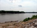 view gallery view galleryN7.1 km |  Fort Osage Boat Ramp Fort Osage Boat Ramp
in Boat Ramps Missouri River boat ramp. posted by: wardnkathy location: Missouri date approved: 05/31/2009 last visited: never |
 view gallery view gallery NW7.2 km NW7.2 km
| Santa Fe Trail Marker - Six Mile Church in Wagon Roads and Trails Santa Fe Trail marker located on Blue Mills Road west of the Fort Osage/Sibley turnoff. posted by: betaylor73 location: Missouri date approved: 04/10/2009 last visited: 10/23/2010 |
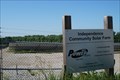 view gallery view gallery W7.7 km W7.7 km
|  Independence Community Solar Farm - Independence, MO Independence Community Solar Farm - Independence, MO
in Solar Power Utility scale photovoltaic solar farm located at 24451 E. Bundschu Road, Independence, MO. posted by: wardnkathy location: Missouri date approved: 06/18/2018 last visited: never |
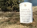 view gallery view gallery S7.7 km S7.7 km
|  Harold William Bauer-Grain Valley, MO Harold William Bauer-Grain Valley, MO
in Medal Of Honor Resting Places World War II Medal of Honor Recipient for action at Guadalcanal, Solomon Islands in 1942. He was killed in action and his remains were never recovered. He has a cenotaph marker in Swan Lake Memorial Park, Grain Valley, MO. posted by: Don.Morfe location: Missouri date approved: 04/11/2018 last visited: 12/14/2021 |
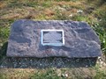 view gallery view galleryW8.9 km |  Potawatomi Trail of Death Marker Potawatomi Trail of Death Marker
in Trail of Tears A marker on the Potawatomi Trail of Death, near Independence, MO. It is located on the Little Blue Trace hiking & bicylcing trail near highway M-78. posted by: mapfan1 location: Missouri date approved: 11/02/2010 last visited: never |
 view gallery view gallery SW10.8 km SW10.8 km
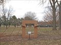
|  Veterans Way Memorial - Blue Springs, MO Veterans Way Memorial - Blue Springs, MO
in Non-Specific Veteran Memorials Veterans memorial in Pink Hill Park. posted by: wardnkathy location: Missouri date approved: 01/23/2021 last visited: never |
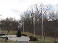
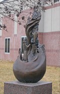
 view gallery view gallerySW10.8 km |  Quasarc - Blue Springs, MO Quasarc - Blue Springs, MO
in Abstract Public Sculptures Blue Springs public art in Pink Hill Park at 2715 NW Park Drive. posted by: wardnkathy location: Missouri date approved: 01/23/2021 last visited: never |
 view gallery view galleryS11.1 km |  Red Bicycle - Blue Springs, MO Red Bicycle - Blue Springs, MO
in Realistic Object Sculptures Public art in Blue Springs along Adams Dairy Parkway. posted by: wardnkathy location: Missouri date approved: 01/25/2021 last visited: never |
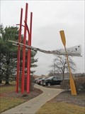
 view gallery view galleryS11.3 km | Subdued Radiance - Blue Springs, MO in Abstract Public Sculptures Blue Springs public art along Adams Dairy Parkway. posted by: wardnkathy location: Missouri date approved: 01/25/2021 last visited: never |
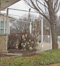
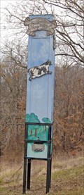 view gallery view galleryS11.4 km |  Sleep Tight - Blue Springs, MO Sleep Tight - Blue Springs, MO
in Unique Bird Houses A chimney swift tower for the swift’s living and nesting that has been enhanced with art along Adams Dairy Parkway. posted by: wardnkathy location: Missouri date approved: 02/12/2021 last visited: never |
 view gallery view gallerySW11.6 km | Selfless - Blue Springs, MO in Abstract Public Sculptures Blue Springs public art at Central Jackson County Fire Protection District Station No. 3. posted by: wardnkathy location: Missouri date approved: 01/25/2021 last visited: never |
 view gallery view galleryS11.7 km | BlueSprings.Net - Blue Springs, MO in Abstract Public Sculptures Blue Springs public art at the Adams Pointe Conference Center. posted by: wardnkathy location: Missouri date approved: 01/27/2021 last visited: never |
 view gallery view galleryS11.9 km | From East of Here - Blue Springs, MO in Abstract Public Sculptures Blue Springs public art at the Adams Pointe Golf Clubhouse. posted by: wardnkathy location: Missouri date approved: 01/27/2021 last visited: never |
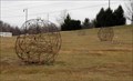 view gallery view galleryS11.9 km | Tumbleweeds - Blue Springs, MO in Abstract Public Sculptures Blue Springs public art at 1601 northeast R. D. Mize Road. This is located near the entrance to the Adams Pointe Golf Club. posted by: wardnkathy location: Missouri date approved: 01/27/2021 last visited: never |
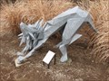
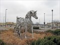 view gallery view galleryS11.9 km |  Arabian - Blue Springs, MO Arabian - Blue Springs, MO
in Figurative Public Sculpture Blue Springs public art in a roundabout at the Adams Dairy Landing shopping center. posted by: wardnkathy location: Missouri date approved: 01/26/2021 last visited: never |
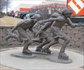 view gallery view galleryS11.9 km | Catch Me If You Can - Blue springs, MO in Figurative Public Sculpture Blue Springs public art near Home Depot at Adams Dairy Parkway and Coronado Dr. posted by: wardnkathy location: Missouri date approved: 01/30/2021 last visited: never |
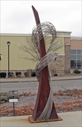 view gallery view galleryS11.9 km | Duel Aspiration - Blue Springs, MO in Abstract Public Sculptures Blue Springs public art at the Adams Dairy Landing shopping center. posted by: wardnkathy location: Missouri date approved: 01/25/2021 last visited: never |
 view gallery view galleryS12.1 km | Bag - Blue Springs, MO in Realistic Object Sculptures Blue Springs public art at the Adams Dairy Landing shopping center. posted by: wardnkathy location: Missouri date approved: 01/25/2021 last visited: never |
|