 view gallery view gallery SE8.4 km SE8.4 km
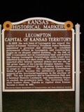
|   Lecompton Capital of Kansas Territory Lecompton Capital of Kansas Territory
in Kansas Historical Markers Kansas historical marker located in service area along I-70 posted by:  BruceS BruceS location: Kansas date approved: 08/09/2007 last visited: 11/05/2021 |
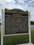 view gallery view gallerySE8.4 km |  Lecompton Capital of Kansas Territory - Tecumseh, KS Lecompton Capital of Kansas Territory - Tecumseh, KS
in Civil Rights Memorials A marker that talks about the beginnings of the Lincoln-Douglas debates. posted by:  bluesnote bluesnote location: Kansas date approved: 04/03/2016 last visited: 04/03/2016 |
 view gallery view gallerySE8.4 km |  Lecompton Capital of Kansas Territory - Tecumseh, KS Lecompton Capital of Kansas Territory - Tecumseh, KS
in U.S. 40 - The National Road Located at a rest area long Interstate 70, just east of Topeka. posted by: bluesnote location: Kansas date approved: 07/30/2015 last visited: 07/30/2015 |
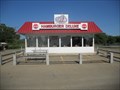
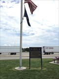 view gallery view gallerySE8.4 km |  Topeka Service Plaza - Tecumseh, KS Topeka Service Plaza - Tecumseh, KS
in Free Overnight RV Parking Locations A rest stop between Kansas City and Topeka on Interstate 70. posted by: bluesnote location: Kansas date approved: 02/20/2016 last visited: 02/20/2016 |
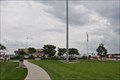 view gallery view gallerySE8.4 km |  Topeka Interstate 70 Westbound Service Plaza Topeka Interstate 70 Westbound Service Plaza
in Highway Rest Areas This Service Plaza is located on westbound Interstate Highway 70 at milepost 188 in Tecumseh, Kansas. posted by: brwhiz location: Kansas date approved: 02/22/2013 last visited: 09/14/2019 |
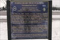
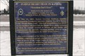
 view gallery view gallerySE8.4 km | Purple Heart Trail in Kansas - Douglas County, KS in Kansas Historical Markers One of 32 markers or signs, each dedicated to a different MOPH recipient. posted by: YoSam. location: Kansas date approved: 03/22/2015 last visited: 09/30/2021 |
 view gallery view gallerySE8.4 km |  Purple Heart Trail Now Goes Through Kansas Purple Heart Trail Now Goes Through Kansas
in News Article Locations One of 32 markers or signs, each dedicated to a different MOPH recipient. posted by: YoSam. location: Kansas date approved: 04/28/2019 last visited: 09/30/2021 |
 view gallery view gallerySE8.4 km |  Purple Heart Trail in Kansas - Douglas County, KS Purple Heart Trail in Kansas - Douglas County, KS
in George Washington One of 32 markers or signs, each dedicated to a different MOPH recipient. posted by: YoSam. location: Kansas date approved: 05/03/2019 last visited: 09/30/2021 |
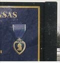
 view gallery view gallerySE8.4 km |  1st Lt. Michael L. Gandy - Douglas County, KS 1st Lt. Michael L. Gandy - Douglas County, KS
in Specific Veteran Memorials 1Lt. Michael L. Gandy, U.S. Army; Killed In Action, 29 March 1968, Vietnam. One of 32 markers or signs, each dedicated to a different MOPH recipient. posted by: YoSam. location: Kansas date approved: 03/22/2015 last visited: 09/30/2021 |
 view gallery view gallerySE8.4 km |  Hardee's - I-70 Westbound Service Plaza ~ Tecumseh, Kansas Hardee's - I-70 Westbound Service Plaza ~ Tecumseh, Kansas
in Carl's Jr./Hardee's Restaurants This Hardee's outlet is located in the Westbound Service Plaza on Interstate Highway 70 at milepost 188 in Tecumseh, Kansas. posted by: brwhiz location: Kansas date approved: 02/21/2013 last visited: 07/22/2015 |
 view gallery view gallerySE8.4 km |  Pizza Hut - Interstate 70 - Tecumseh, KS Pizza Hut - Interstate 70 - Tecumseh, KS
in Pizza Hut Restaurants A food court at a rest area along I-70. posted by: bluesnote location: Kansas date approved: 07/27/2015 last visited: 07/27/2015 |
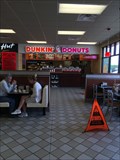 view gallery view gallerySE8.4 km |  Dunkin Donuts - Interstate 70 - Tecumseh, KS Dunkin Donuts - Interstate 70 - Tecumseh, KS
in Dunkin Donuts' A food court at a rest area along I-70. posted by: bluesnote location: Kansas date approved: 07/27/2015 last visited: 07/27/2015 |
 view gallery view gallerySE8.4 km |  Taco Bell - Interstate 70 - Tecumseh, KS Taco Bell - Interstate 70 - Tecumseh, KS
in Taco Bell Restaurants A food court at a rest area along I-70. posted by: bluesnote location: Kansas date approved: 07/27/2015 last visited: 07/27/2015 |
 view gallery view gallerySE8.4 km |  Hardee's - Interstate 70 - Tecumseh, KS Hardee's - Interstate 70 - Tecumseh, KS
in Wi-Fi Hotspots Hardee's free wifi. posted by: bluesnote location: Kansas date approved: 08/02/2015 last visited: 08/02/2015 |
 view gallery view gallerySE8.4 km |  Lawrence 18 Miles East Map - Tecumseh, KS Lawrence 18 Miles East Map - Tecumseh, KS
in 'You Are Here' Maps This is one of 5 maps at this same location. posted by: bluesnote location: Kansas date approved: 07/26/2015 last visited: 07/26/2015 |
 view gallery view gallerySE8.4 km | Topeka 10 Miles West Map - Tecumseh, KS in 'You Are Here' Maps This is one of 5 maps at this same location. posted by: bluesnote location: Kansas date approved: 07/26/2015 last visited: 07/26/2015 |
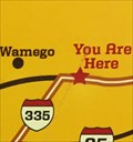 view gallery view gallerySE8.4 km | Wamego 54 Miles West Map - Tecumseh, KS in 'You Are Here' Maps This is one of 5 maps at this same location. posted by: bluesnote location: Kansas date approved: 07/26/2015 last visited: 07/26/2015 |
 view gallery view gallerySE8.4 km | Emporia 67 Miles Southwest Map - Tecumseh, KS in 'You Are Here' Maps This is one of 5 maps at this same location. posted by: bluesnote location: Kansas date approved: 07/26/2015 last visited: 07/26/2015 |
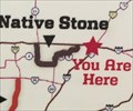 view gallery view gallerySE8.4 km | Native Stone Map - Tecumseh, KS in 'You Are Here' Maps This is one of 5 maps at this same location. posted by: bluesnote location: Kansas date approved: 07/26/2015 last visited: 07/26/2015 |
 view gallery view gallery W8.5 km W8.5 km
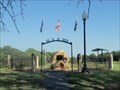
|  Vietnam War Memorial, Garfield Park, North Topeka, KS, USA Vietnam War Memorial, Garfield Park, North Topeka, KS, USA
in Vietnam War Memorials This Vietnam War Memorial in Garfield Park was dedicated in memory of 12 men from North Topeka who died in the Vietnam War. posted by: Marine Biologist location: Kansas date approved: 08/27/2011 last visited: 06/28/2019 |
 view gallery view galleryW8.5 km |  Bill's Diner - Topeka, KS Bill's Diner - Topeka, KS
in Independent Diners Bill's Diner is a small diner located in Topeka, Kansas, USA. posted by: Marine Biologist location: Kansas date approved: 08/18/2011 last visited: 09/06/2014 |
 view gallery view galleryW8.5 km |  Bill's Diner - "Have Mercy" - Topeka, KS Bill's Diner - "Have Mercy" - Topeka, KS
in Zippy the Pinhead Locations When Zippy and Griff visited this restaurant in Topeka, Kansas, it was known as Patty's Place. Now it's Bill's Diner. Although the name of the place has changed, it still looks pretty much the same. posted by: Marine Biologist location: Kansas date approved: 08/06/2011 last visited: 09/06/2014 |
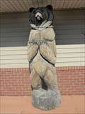 view gallery view galleryW8.5 km |  Standing Grizzly - Topeka, KS Standing Grizzly - Topeka, KS
in Bear Statues This grizzly bear is standing in front of the Home Improvement Gallery in Topeka, Kansas, USA. posted by: Marine Biologist location: Kansas date approved: 08/28/2011 last visited: 09/06/2014 |
 view gallery view gallery S8.9 km S8.9 km
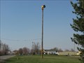
|  Shawnee County Outdoor Warning Device #60 Shawnee County Outdoor Warning Device #60
in Outdoor Warning Sirens Siren used for Tornadoes and National Emergencies. posted by:  kswx29 kswx29 location: Kansas date approved: 07/16/2008 last visited: never |
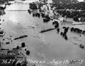 view gallery view galleryW8.9 km | Santa Fe Out at Topeka -- Topeka KS in News Article Locations This former Atchison Topeka & Santa Fe RR truss bridge over the Kansas River was built in 1920, and was washed out in a historic flood on 12 July 1951. posted by: Benchmark Blasterz location: Kansas date approved: 04/12/2013 last visited: 03/14/2013 |
|