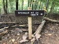
 view gallery view gallery E2.4 km E2.4 km
|   1000 Mile Marker - Bluemont, Virginia 1000 Mile Marker - Bluemont, Virginia
in Appalachian Trail Located on the Appalachian Trail North of Morgans Mill Road. posted by:  flyingmoose flyingmoose location: Virginia date approved: 10/25/2021 last visited: 03/24/2023 |
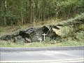 view gallery view galleryE4.7 km |  TWA Flight 514 - "Cleared for the Approach" TWA Flight 514 - "Cleared for the Approach"
in Plane Crash Sites TWA Flight 514, a Boeing 727-231 with tail number N54328 crashed onto a mountain top near Berryville, Virginia during approach to Dulles International on December 1, 1974. All 85 passengers and 7 crewmembers were killed. posted by:  Neo_Geo Neo_Geo location: Virginia date approved: 09/23/2006 last visited: never |
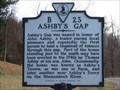 view gallery view gallery SW6.1 km SW6.1 km
|  Ashby’s Gap Ashby’s Gap
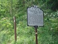
in Virginia Historical Markers Erected 1997 by Department of Historic Resources. (Marker Number B 23.) posted by: turnersrugs location: Virginia date approved: 03/11/2013 last visited: never |
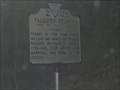 view gallery view gallerySW6.4 km | Fauquier County / Clark County in Virginia Historical Markers This sign is located at the corner near the tri-county corner of Clark County, Loudon County, and Fauquier County. It gives a brief description and bit of history of Fauquier County on one side, and Clarke County on the other side. posted by: pixieslayer location: Virginia date approved: 07/27/2006 last visited: 11/02/2009 |
 view gallery view gallery S6.8 km S6.8 km
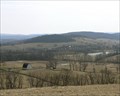
|  Paris, Virginia Paris, Virginia
in Small Town, Big Name Paris, Virginia in Fauquier County at the foot of the Shennandoah posted by: Rivers End location: Virginia date approved: 01/04/2006 last visited: 11/21/2015 |
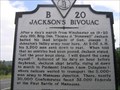 view gallery view galleryS6.9 km | Jackson's Bivouac in Virginia Historical Markers This marker describes General Stonewall Jackson's activities in the hours leading up to his arrival at the First Battle of Manassas (also known as the First Battle of Bull Run). With the arrival of Jackson's rested troops, the Confederate Army was able to claim a victory over the Federal troops at the First Battle of Manassas, which was also the battle where General Jackson received his nickname of "Stonewall". posted by: pixieslayer location: Virginia date approved: 07/27/2006 last visited: 11/21/2015 |
 view gallery view gallery NE7.4 km NE7.4 km
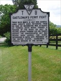
| Castleman's Ferry Fight in Virginia Historical Markers Located on the eastbound side of route seven before you cross the river. posted by: flyingmoose location: Virginia date approved: 06/06/2006 last visited: never |
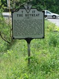 view gallery view galleryNE7.4 km | The Retreat in Virginia Historical Markers Located right off of Westbound route 7 at the last intersection before crossing the river. There is some growth near the marker but might get trimmed from time to time. Parking is safe, but there is no scenic factor here. This one also seems to not be in any online database. posted by: flyingmoose location: Virginia date approved: 06/06/2006 last visited: 03/26/2013 |
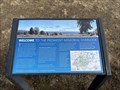 view gallery view gallerySW7.7 km |  Piedmont Memorial Overlook - Delaplane, Virginia Piedmont Memorial Overlook - Delaplane, Virginia
in Orientation Tables Located on the edge of Sky Meadows State Park near the Appalachian Trail. posted by: flyingmoose location: Virginia date approved: 05/17/2023 last visited: never |
 view gallery view gallerySW8.2 km | AT Intersection, Ambassador Whitehouse Trail to Sky Meadows SP, Nr. Ashby Gap, VA in Appalachian Trail Intersection sign for the AT and Ambassador Whitehouse trail leading to Sky Meadows SP. posted by: garmin_geek location: Virginia date approved: 02/03/2009 last visited: 10/11/2009 |
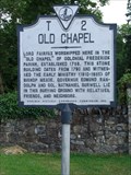 view gallery view gallery NW8.4 km NW8.4 km
| Old Chapel in Virginia Historical Markers Located on the Northbound side of Route 340, this marker is located in front of The Old Chapel, There are many grave markers from this time period as well as a Civil War Memorial. posted by: flyingmoose location: Virginia date approved: 08/08/2006 last visited: 12/06/2012 |
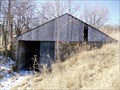 view gallery view galleryS8.7 km |  Hog Barn or Silage Clamp, Sky Meadows SP, Delaplane, VA Hog Barn or Silage Clamp, Sky Meadows SP, Delaplane, VA
in Unoccupied Buildings, Shacks, and Cabins Abandon structure on the old farm that makes up Sky Meadows State Park. posted by: garmin_geek location: Virginia date approved: 02/06/2009 last visited: never |
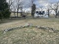 view gallery view galleryS8.7 km |  CPL Randall Morgan Memorial - Delaplane, Virginia CPL Randall Morgan Memorial - Delaplane, Virginia
in U.S. Revolutionary War Memorials A memorial to a Continental Army Soldier at Sky Meadows State Park. posted by: flyingmoose location: Virginia date approved: 05/31/2023 last visited: never |
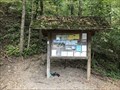
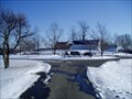 view gallery view galleryS8.7 km |  Sky Meadows SP, Delaplane, VA Sky Meadows SP, Delaplane, VA
in Hiking and walking trailheads Fantastic VA state park with more than 12 miles of hiking trails ranging in difficulty from moderate to hard. Access to the Appalachian trail. $4.00 day use fee. posted by: garmin_geek location: Virginia date approved: 02/02/2009 last visited: 09/16/2012 |
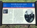 view gallery view galleryS8.7 km |  Mount Bleak Farm - Deleplane, Virginia Mount Bleak Farm - Deleplane, Virginia
in Civil War Discovery Trail Sites Located near the main parking area at Sky Meadows. posted by: flyingmoose location: Virginia date approved: 02/19/2023 last visited: never |
 view gallery view galleryS8.7 km |  Sky Meadows SP, Delaplane, VA Sky Meadows SP, Delaplane, VA
in Scenic Hikes Sky Meadows State Park, a jewel of the Virginia park system. The park has more than 12 miles of hiking trails ranging in difficulty from moderate to hard. Access to the Appalachian Trail. posted by: garmin_geek location: Virginia date approved: 02/03/2009 last visited: never |
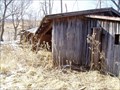 view gallery view galleryS8.7 km | Cattle Loafing Shed, Sky Meadows SP, Delaplane, VA in Unoccupied Buildings, Shacks, and Cabins Sky Meadows State Park was at one time an old, hill side farm. I asked the rangers about this shed. They called it a loafing shed, to protect horses and cattle from the weather and sun. posted by: garmin_geek location: Virginia date approved: 02/04/2009 last visited: never |
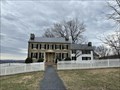 view gallery view galleryS8.9 km |  Mt. Bleak--Skye Farm - Delaplane, Virginia Mt. Bleak--Skye Farm - Delaplane, Virginia
in U.S. National Register of Historic Places Located within Sky Meadows State Park. posted by: flyingmoose location: Virginia date approved: 05/09/2023 last visited: never |
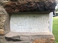 view gallery view galleryE8.9 km |  Austins Grove United Methodist Church - Bluemont, Virginia Austins Grove United Methodist Church - Bluemont, Virginia
in Dated Buildings and Cornerstones Located on the eastbound side of Austin Grove Road. posted by: flyingmoose location: Virginia date approved: 01/30/2023 last visited: never |
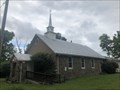 view gallery view galleryE8.9 km |  Austins Grove United Methodist Church - Bluemont, Virginia Austins Grove United Methodist Church - Bluemont, Virginia
in Methodist Churches Located on the eastbound side of Austin Grove Road. posted by: flyingmoose location: Virginia date approved: 01/30/2023 last visited: never |
 view gallery view galleryNE8.9 km | Appalachian Trail Historic Marker - Bluemont, Virginia in Appalachian Trail Trail marker and historic marker along Route 7 at Snickers Gap. posted by: flyingmoose location: Virginia date approved: 10/17/2020 last visited: never |
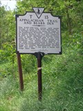 view gallery view galleryNE8.9 km | Appalachian Trail and Bear's Den in Virginia Historical Markers Located at the Appalachian Trail crossing along the eastbound side of route 7. This is also my favorite marker to date as I hiked the trail in 2003 and have experienced the history of this marker.
The Bear's Den is just a bit further to the east and then turn right and you will see the sign. beautiful place and the caretaker is very nice. posted by: flyingmoose location: Virginia date approved: 06/06/2006 last visited: 04/20/2016 |
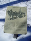 view gallery view galleryS9 km |  The Road To Simper's Mill, Sky Meadows SP, Delaplane, VA The Road To Simper's Mill, Sky Meadows SP, Delaplane, VA
in Signs of History Sign detailing the history of a road which used to connect Paris, VA with two gristmills. posted by: garmin_geek location: Virginia date approved: 02/06/2009 last visited: never |
 view gallery view galleryNE9 km | Raven Rocks Trailhead - Bluemont, Virginia in Appalachian Trail Located on the westbound side of Route 7 on Pine Grove Road. posted by: flyingmoose location: Virginia date approved: 10/25/2021 last visited: never |
 view gallery view galleryNE9 km | Raven Rocks Trailhead - Bluemont, Virginia in Hiking and walking trailheads Located on the westbound side of Route 7 on Pine Grove Road. posted by: flyingmoose location: Virginia date approved: 10/25/2021 last visited: never |
|