 view gallery view gallery NW1.9 km NW1.9 km
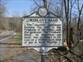
|   Oriskany Sand Oriskany Sand
in West Virginia Historical Markers A sign telling us about the massive sandstone formations. posted by:  dukemartin dukemartin location: West Virginia date approved: 04/16/2018 last visited: 04/16/2018 |
 view gallery view gallery W3.1 km W3.1 km
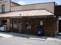
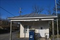
|  Baker, WV 26801 Baker, WV 26801
in U.S. Post Offices Baker WV 26801 Post Office posted by: dukemartin location: West Virginia date approved: 05/31/2012 last visited: 11/03/2019 |
 view gallery view gallery E11.1 km E11.1 km
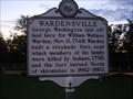
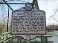
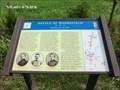
| Wardensville in West Virginia Historical Markers A short history of events that occurred near Wardensville. posted by: Paintedwarrior location: West Virginia date approved: 08/26/2013 last visited: 08/30/2013 |
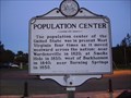 view gallery view galleryE11.1 km | Population Center in West Virginia Historical Markers A sign listing the location of the population center of the United States as it moved westward across West Virginia. posted by: Paintedwarrior location: West Virginia date approved: 08/26/2013 last visited: 08/30/2013 |
 view gallery view gallery S11.9 km S11.9 km
|  Big Schloss, Wolf Gap Rec. Area ~ Nr. Edinburg, VA Big Schloss, Wolf Gap Rec. Area ~ Nr. Edinburg, VA
in Mountain Summits Big Schloss (German for Castle) is another treasure in the George Washington National Forest. A relatively easy hike at only 4.4 miles and 1,000 vertical feet from the parking lot at Wolf Gap. posted by:  garmin_geek garmin_geek location: Virginia date approved: 01/28/2009 last visited: 11/26/2023 |
 view gallery view gallery SW12.9 km SW12.9 km
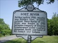
| Lost River in West Virginia Historical Markers Tells about battle between Virginia frontiersmen and band of 50 French and Indians. posted by: Paintedwarrior location: West Virginia date approved: 07/07/2012 last visited: 07/14/2012 |
 view gallery view gallerySW16.4 km | Lost City, West Virginia 26810 in U.S. Post Offices Post office for Lost City in Hardy County, West Virginia. posted by: bitmapped location: West Virginia date approved: 11/30/2008 last visited: 05/02/2014 |
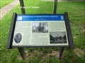
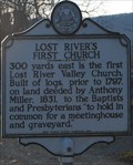 view gallery view gallerySW16.4 km | Lost River's First Church in West Virginia Historical Markers A historical marker about Lost River's first church. posted by: bitmapped location: West Virginia date approved: 04/15/2009 last visited: 05/28/2012 |
 view gallery view gallery SE19.5 km SE19.5 km
|  34M 1934 34M 1934
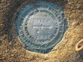
in U.S. Benchmarks 34M At top of mountain in Shenandoah County posted by: slippeddisk location: Virginia date approved: 10/06/2007 last visited: never |
 view gallery view gallerySE20 km | ET 33 MAX 1964 Reset 1974 in U.S. Benchmarks ET 33MAX 1964 RESET 1974 Shenandoah County, Virginia posted by: slippeddisk location: Virginia date approved: 07/12/2009 last visited: never |
 view gallery view gallery NE20 km NE20 km
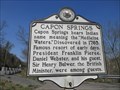
| Capon Springs in West Virginia Historical Markers Capon Spring bears the Indian name meaning the "Medicine Waters". posted by: dukemartin location: West Virginia date approved: 04/16/2018 last visited: 04/16/2018 |
 view gallery view galleryNE20 km | Capon Lake Whipple Truss Bridge in West Virginia Historical Markers West Virginia's oldest extant metal truss bridge. posted by: dukemartin location: West Virginia date approved: 04/16/2018 last visited: 04/16/2018 |
 view gallery view gallerySE20.3 km |  Fetzer Fetzer
in Azimuth Benchmarks Azimuth mark for station Fitzer in Shenandoah County VA. posted by: slippeddisk location: Virginia date approved: 09/10/2007 last visited: 11/01/2008 |
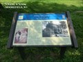 view gallery view galleryW21.4 km |  Mill Island-Confederate Hospital - Moorefield WV Mill Island-Confederate Hospital - Moorefield WV
in U.S. Civil War Sites Marker is in Moorefield, West Virginia, in Hardy County on Mill Island Drive, Moorefield WV 26836 posted by: Don.Morfe location: West Virginia date approved: 07/11/2023 last visited: 07/11/2023 |
 view gallery view galleryW21.7 km | Cemetery Hill-Fighting Among the Tombstones - Moorefield WV in U.S. Civil War Sites Marker is in Moorefield, West Virginia, in Hardy County at 192 Olivet Drive, Moorefield WV 26836 in Olivet Cemetery. posted by: Don.Morfe location: West Virginia date approved: 07/11/2023 last visited: 07/11/2023 |
 view gallery view galleryW21.7 km | Battle of Moorefield-Running for the Hills - Moorefield WV in U.S. Civil War Sites Marker is in Moorefield, West Virginia, in Hardy County at 596 Harness Rd, Moorefield WV 26836 posted by: Don.Morfe location: West Virginia date approved: 07/11/2023 last visited: 07/11/2023 |
 view gallery view galleryW21.7 km | Battle of Moorefield-Running for the Hills - Moorefield WV in Civil War Discovery Trail Sites Confederate Gen. John McCausland's cavalry brigade was camped in the fields in front of you on this side of the South Branch of the Potomac River posted by: Don.Morfe location: West Virginia date approved: 08/25/2020 last visited: 10/04/2021 |
 view gallery view galleryW21.7 km | Moorefield, WV 26836 in U.S. Post Offices Moorefield WV 26836 Post Office posted by: dukemartin location: West Virginia date approved: 05/31/2012 last visited: never |
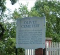 view gallery view galleryW21.7 km | Olivet Cemetery - Moorefield WV in U.S. Civil War Sites Soldiers of both north and south buried here, battles took place on the cemetery and adjoining hill Jan. 3, 1863. posted by: Don.Morfe location: West Virginia date approved: 08/25/2020 last visited: 10/04/2021 |
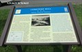
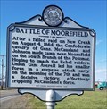 view gallery view galleryW22.2 km | Battle of Moorefield in West Virginia Historical Markers A sign describing some the the civil war activities that took place here. posted by: dukemartin location: West Virginia date approved: 04/09/2018 last visited: 04/09/2018 |
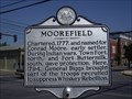 view gallery view galleryW22.4 km | Moorefield in West Virginia Historical Markers Tells how Moorefield got its name. posted by: Paintedwarrior location: West Virginia date approved: 07/07/2012 last visited: 09/01/2004 |
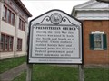 view gallery view galleryW22.4 km | Presbyterian Church in West Virginia Historical Markers Tells the use of the church during he civil war. posted by: Paintedwarrior location: West Virginia date approved: 03/21/2016 last visited: 03/20/2016 |
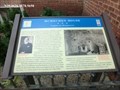
 view gallery view galleryW22.4 km | Moorefield Presbyterian Church-Confederate Sanctuary - Moorefield WV in U.S. Civil War Sites Marker is in Moorefield, West Virginia, in Hardy County at 109 South Main Street, Moorefield WV 26836. posted by: Don.Morfe location: West Virginia date approved: 07/11/2023 last visited: 07/11/2023 |
 view gallery view galleryW22.4 km | Moorefield Presbyterian Church Confederate Sanctuary - Moorefield WV in Civil War Discovery Trail Sites The Rev. William V. Wilson, the minister, was an outspoken Confederate sympathizer as was his congregation, which was composed of Moorefield's prominent, wealthy residents. Many sons of the older congregants served in the county militia and in regular Confederate army units. posted by: Don.Morfe location: West Virginia date approved: 03/11/2020 last visited: 10/08/2021 |
 view gallery view galleryW22.4 km | McMechen House-Confederate Headquarters - Moorefield WV 26836 in Civil War Discovery Trail Sites This house was constructed about 1853 for Samuel A. McMechen, merchant, father of five daughters and deacon of Moorefield Presbyterian Church up the street on your right. posted by: Don.Morfe location: West Virginia date approved: 08/25/2020 last visited: 10/04/2021 |
|