 view gallery view gallery NE1.9 km NE1.9 km
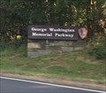
|   George Washington Memorial Parkway - McLean, VA George Washington Memorial Parkway - McLean, VA
in Wikipedia Entries One of the only roads that serve as a national park. The above coordinates are for the western terminus of the GW parkway, at I-495 in McLean, Virginia where the photos were taken. The eastern terminus is Mt. Vernon. posted by:  bluesnote bluesnote location: Virginia date approved: 12/22/2018 last visited: 03/23/2022 |
 view gallery view galleryNE1.9 km |  George Washington Memorial Parkway - McLean, VA George Washington Memorial Parkway - McLean, VA
in National Parks of the World One of the only roads that serve as a national park. The above coordinates are for the western terminus of the GW parkway, at I-495 in McLean, Virginia where the photos were taken. The eastern terminus is Mt. Vernon. posted by: bluesnote location: Virginia date approved: 12/21/2018 last visited: 03/23/2022 |
 view gallery view galleryNE1.9 km | ") George Washington Memorial Parkway - McLean, VA George Washington Memorial Parkway - McLean, VA
in National Parks (U.S.) One of the only roads that serve as a national park. The above coordinates are for the western terminus of the GW parkway, at I-495 in McLean, Virginia where the photos were taken. The eastern terminus is Mt. Vernon. posted by: bluesnote location: Virginia date approved: 12/22/2018 last visited: 03/23/2022 |
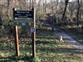
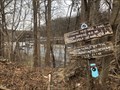 view gallery view gallery N1.9 km N1.9 km
|  Potomac Heritage Trail - McLean, Virginia Potomac Heritage Trail - McLean, Virginia
in Hiking and walking trailheads Located at the end of Live Oak Road. posted by: flyingmoose location: Virginia date approved: 07/05/2022 last visited: never |
 view gallery view gallery S2.3 km S2.3 km
|  Church of Christ Scientist - McLean, Virginia Church of Christ Scientist - McLean, Virginia
in Church of Christ Scientist Located along Chain Bridge Road in Mclean. posted by: flyingmoose location: Virginia date approved: 10/29/2020 last visited: never |
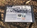 view gallery view gallery NW2.4 km NW2.4 km
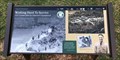
|  Burling Defenders - McLean, Virginia Burling Defenders - McLean, Virginia
in Signs of History Located along the river trail at Scotts Run Nature Preserve. posted by: flyingmoose location: Virginia date approved: 10/06/2022 last visited: never |
 view gallery view galleryN2.4 km | Bill Goat Trail (Section C East End) - Potomac, Maryland in Hiking and walking trailheads Eastern End of the Billy Goat Trail Section C posted by: flyingmoose location: Maryland date approved: 07/19/2021 last visited: never |
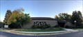
 view gallery view gallery E2.6 km E2.6 km
|  Clemyjontri Park Clemyjontri Park
in Accessible-Designed Recreational Locations Located on the eastern end of Georgetown Pike before it intersects with Dolly Madison Boulevard. posted by: flyingmoose location: Virginia date approved: 02/18/2021 last visited: never |
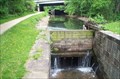
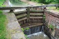
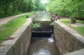
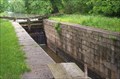 view gallery view galleryN2.6 km |  C&O Canal - Lock #14 C&O Canal - Lock #14
in Waterway Locks, Planes and Lifts Lock #14 (of 74) on the Chesapeake & Ohio Canal - Seven Locks #7 - Mile 9.47 posted by:  ParrotRob ParrotRob location: Maryland date approved: 05/17/2006 last visited: 07/04/2013 |
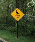 view gallery view galleryN2.6 km |  Goose Crossing - Potomac, Maryland Goose Crossing - Potomac, Maryland
in Uncommon Crossing Signs Goose crossing sign located along Clara Barton Parkway. posted by: flyingmoose location: Maryland date approved: 05/17/2021 last visited: never |
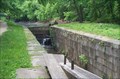
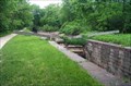 view gallery view galleryN2.6 km | C&O Canal - Lock #13 in Waterway Locks, Planes and Lifts Lock #13 (of 74) on the Chesapeake & Ohio Canal - Seven Locks #6 - Mile 9.37 posted by: ParrotRob location: Maryland date approved: 05/17/2006 last visited: 07/04/2013 |
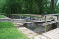
 view gallery view galleryN2.6 km | C&O Canal - Lock #12 in Waterway Locks, Planes and Lifts Lock #12 (of 74) on the Chesapeake & Ohio Canal - Seven Locks #5 - Mile 9.29 posted by: ParrotRob location: Maryland date approved: 05/17/2006 last visited: 07/04/2013 |
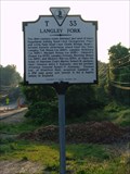 view gallery view galleryE2.7 km |  Langley Fork Langley Fork
in Virginia Historical Markers Located along the westbound side of route 193/ Georgetown pike. There is ample parking along the road, even in traffic. There is also a sports park along the same road with the name Langley fork that is primarily a soccer field. posted by: flyingmoose location: Virginia date approved: 05/26/2006 last visited: 01/22/2022 |
 view gallery view galleryNW2.7 km |  NP 2 MD - Potomac, Maryland NP 2 MD - Potomac, Maryland
in Civilian Conservation Corps CCC Camp that was located at the southern end of Bear Island. posted by: flyingmoose location: Maryland date approved: 07/19/2021 last visited: never |
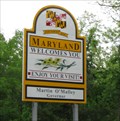
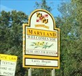 view gallery view galleryN2.7 km |  Welcome to Maryland - Glen Echo, MD Welcome to Maryland - Glen Echo, MD
in Welcome Signs A Maryland welcome sign on I-495 (Capital Beltway) as you cross over the Potomac River from McLean, Virginia. posted by: bluesnote location: Maryland date approved: 02/22/2021 last visited: 02/22/2021 |
 view gallery view galleryN2.7 km |  MD/VA on I-495 MD/VA on I-495
in Border Crossings The VA/MD crossing on I-495. This border crossing goes over the Potomac Border. posted by: saopaulo1 location: Maryland date approved: 05/14/2009 last visited: 10/06/2018 |
 view gallery view galleryNE2.7 km | C&O Canal - Lock #11 in Waterway Locks, Planes and Lifts Lock #11 (of 74) on the Chesapeake & Ohio Canal - Seven Locks #4 - Mile 8.97 posted by: ParrotRob location: Maryland date approved: 05/17/2006 last visited: 07/04/2013 |
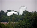 view gallery view gallery SW2.9 km SW2.9 km
|  McLean Duo at Dulles Toll road and 123 McLean Duo at Dulles Toll road and 123
in Water Towers A brother and sister water tower photo, taken from Capital One Drive parking lot and 123 in McLean, Va. posted by: DoUW4W location: Virginia date approved: 07/23/2008 last visited: never |
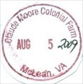
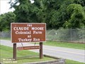 view gallery view galleryE2.9 km | Claude Moore Colonial Farm - McLean VA in Wikipedia Entries Claude Moore Colonial Farm, originally Turkey Run Farm, was a U.S. park in Virginia re-creating and re-enacting life on a tenant farm circa 1771. It located at 6310 Georgetown Pike, McLean, VA 22101. posted by: Don.Morfe location: Virginia date approved: 01/07/2024 last visited: 01/07/2024 |
 view gallery view galleryE2.9 km |  Ranger Station at Claude Moore Colonial Farm - McLean VA Ranger Station at Claude Moore Colonial Farm - McLean VA
in Ranger Stations The Ranger Station at Claude Moore Colonial Farm is in the visitor center. Here one may obtain a NPS Cancellation Stamp. posted by: Don.Morfe location: Virginia date approved: 01/08/2024 last visited: 01/08/2024 |
 view gallery view galleryNE2.9 km | C&O Canal - Lock #10 in Waterway Locks, Planes and Lifts Lock #10 (of 74) on the Chesapeake and Ohio Canal - Seven Locks #3 - Mile 8.79 posted by: ParrotRob location: Maryland date approved: 05/17/2006 last visited: 07/04/2013 |
 view gallery view galleryNE3.1 km | C&O Canal - Lock #9 in Waterway Locks, Planes and Lifts Lock #9 (of 74) on the Chesapeake & Ohio Canal - Seven Locks #2 - Mile 8.70 posted by: ParrotRob location: Maryland date approved: 05/17/2006 last visited: 07/04/2013 |
 view gallery view galleryE3.1 km |  Claude Moore Colonial Farm Claude Moore Colonial Farm
in NPS Passport Cancellation Stations The NPS operated the farm until 1981 until budget considerations. Supporters rallied and formed the Friends of Turkey Run, Later renamed the Claude Moore Colonial Farm. posted by: Don.Morfe location: Virginia date approved: 12/25/2019 last visited: 10/10/2021 |
 view gallery view galleryE3.1 km | Claude Moore Colonial Farm in National Parks (U.S.) The original Turkey Run Farm was designed and built as an educational opportunity to simulate how poor, 18th-century farmers lived and worked. However, it was a representation only, and there is no historical evidence that this area was a Colonial farm. posted by: Don.Morfe location: Virginia date approved: 12/18/2019 last visited: 10/28/2021 |
 view gallery view galleryNE3.2 km | C&O Canal - Lock #8 in Waterway Locks, Planes and Lifts Lock #8 (of 74) on the Chesapeake & Ohio Canal - Seven Locks #1 - Mile 8.33 posted by: ParrotRob location: Maryland date approved: 05/17/2006 last visited: 04/13/2014 |
|