 view gallery view gallery E4.3 km E4.3 km
|   FIRST - Calhoun County Court - Big Bend WV FIRST - Calhoun County Court - Big Bend WV
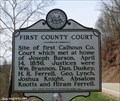
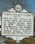
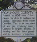
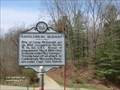
in First of its Kind First County Court-Site of first Calhoun County Court which met at home of Joseph Burson, April 14, 1856. posted by:  Don.Morfe Don.Morfe location: West Virginia date approved: 03/09/2023 last visited: 03/09/2023 |
 view gallery view galleryE4.3 km |  First County Court First County Court
in West Virginia Historical Markers Calhoun County, WV. First County Court posted by: two-bit Joe location: West Virginia date approved: 02/12/2007 last visited: 06/24/2020 |
 view gallery view gallery NW9 km NW9 km
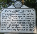
| Population Center in West Virginia Historical Markers One of four locations that the population center of the United States occurred within West Virginia. posted by:  dukemartin dukemartin location: West Virginia date approved: 06/27/2020 last visited: never |
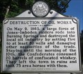 view gallery view galleryNW9.8 km | Destruction of Oil Works in West Virginia Historical Markers Confederates destroyed Oil wells and took horses with them. posted by: dukemartin location: West Virginia date approved: 06/27/2020 last visited: never |
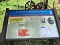
 view gallery view galleryNW9.8 km |  Burning Springs Oil Field -"...drank all the whiskey and burned all the oil" - Burning Springs WV Burning Springs Oil Field -"...drank all the whiskey and burned all the oil" - Burning Springs WV
in U.S. Civil War Sites On May 9, 1863, Confederate Gen. William E. “Grumble” Jones led his cavalrymen here to Burning Springs (Oiltown) before continuing southeast. His men set the oil fields afire, and the burning oil turned the Little Kanawha River into a sheet of flames posted by: Don.Morfe location: West Virginia date approved: 07/05/2023 last visited: 07/05/2023 |
 view gallery view galleryNW9.8 km |  Burning Springs Park - Elizabeth, WV Burning Springs Park - Elizabeth, WV
in Official Local Tourism Attractions The Burning Springs Park is located on State Route 5, Elizabeth WV 26160. posted by: Don.Morfe location: West Virginia date approved: 05/05/2024 last visited: 05/05/2024 |
 view gallery view galleryNW9.8 km |  Burning Springs Oil Field - Burning Springs WV Burning Springs Oil Field - Burning Springs WV
in Battlefields On May 9, 1863, Confederate Gen. William E. “Grumble” Jones led his cavalrymen here to Burning Springs (Oiltown) before continuing southeast. His men set the oil fields afire, and the burning oil turned the Little Kanawha River into a sheet of flames posted by: Don.Morfe location: West Virginia date approved: 11/21/2020 last visited: 10/16/2021 |
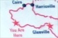 view gallery view galleryNW9.8 km |  'You Are Here' Maps - Burning Springs Oil Field - Burning Springs WV 'You Are Here' Maps - Burning Springs Oil Field - Burning Springs WV
in 'You Are Here' Maps The 'You Are Here' Maps shows that you are Burning Springs Oil Field in Burning Springs WV. posted by: Don.Morfe location: West Virginia date approved: 05/05/2024 last visited: 05/05/2024 |
 view gallery view galleryNW9.8 km | Burning Springs Oil Field - Burning Springs WV in Civil War Discovery Trail Sites On May 9, 1863, Confederate Gen. William E. “Grumble” Jones led his cavalrymen here to Burning Springs (Oiltown) before continuing southeast. posted by: Don.Morfe location: West Virginia date approved: 08/14/2020 last visited: 10/05/2021 |
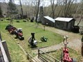 view gallery view galleryNW9.8 km |  Burning Springs Complex - Burning Springs WV Burning Springs Complex - Burning Springs WV
in U.S. National Register of Historic Places Burning Springs Complex is also known as Rathbone and Karns Wells. It is
along the N bank of the Kanawha River from the confluence of Burning Springs Run, Burning Springs WV. posted by: Don.Morfe location: West Virginia date approved: 05/05/2024 last visited: 05/05/2024 |
 view gallery view galleryNW9.8 km |  Burning Springs Complex - Burning Springs WV Burning Springs Complex - Burning Springs WV
in Wikipedia Entries Burning Springs Complex, also known as the Rathbone and Karns Wells, is a national historic district located at Burning Springs, Wirt County, West Virginia. posted by: Don.Morfe location: West Virginia date approved: 05/05/2024 last visited: 05/05/2024 |
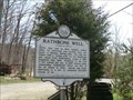
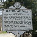 view gallery view galleryNW9.8 km | FIRST-Well in West Virginia drilled solely for petroleum - Rathbone Well - Burning Springs WV in First of its Kind The marker is on WV Route 5, Burning Springs, WV. In 1863, General Jones commanding Confederate forces set fire to the oil stored in tanks, barrels and boats, destroying in a day an estimated 300,000 barrels of oil. posted by: Don.Morfe location: West Virginia date approved: 09/01/2023 last visited: 09/01/2023 |
 view gallery view galleryNW9.8 km | Rathbone Well - Burning Springs WV in Battlefields The marker is on WV Route 5, Burning Springs, WV. In 1863, General Jones commanding Confederate forces set fire to the oil stored in tanks, barrels and boats, destroying in a day an estimated 300,000 barrels of oil. posted by: Don.Morfe location: West Virginia date approved: 09/01/2023 last visited: 09/01/2023 |
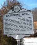 view gallery view galleryNW9.8 km | Rathbone Well in West Virginia Historical Markers Rathbone Well Wirt County, WV posted by: two-bit Joe location: West Virginia date approved: 02/12/2007 last visited: 08/31/2023 |
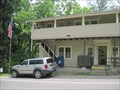
 view gallery view galleryE11.4 km |  Grantsville, WV. 26147 Grantsville, WV. 26147
in U.S. Post Offices Grantsville WV Post Office posted by: dukemartin location: West Virginia date approved: 08/15/2012 last visited: never |
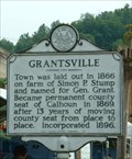 view gallery view galleryE11.6 km | Grantsville in West Virginia Historical Markers Grantsville, WV posted by: two-bit Joe location: West Virginia date approved: 02/12/2007 last visited: 11/23/2011 |
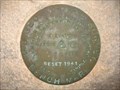 view gallery view galleryE11.6 km |  715 Feet - Reset 1941 - Grantsville, WV 715 Feet - Reset 1941 - Grantsville, WV
in U.S. Benchmarks USGS Benchmark in Grantsville, West Virginia.
Possibly a replacement for BM HX1696, which was not found in 1967.
No unique identifier - only the elevation and date it was "re-set". posted by: BURKOWSKI location: West Virginia date approved: 02/23/2008 last visited: never |
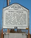 view gallery view galleryNW12.2 km | Ruble Church in West Virginia Historical Markers Ruble Church Wirt County, WV posted by: two-bit Joe location: West Virginia date approved: 02/12/2007 last visited: 06/24/2020 |
 view gallery view galleryE14.2 km | Big Springs, WV - 26137 in U.S. Post Offices This post office is located on SR 16 at 6657 N Calhoun Hwy in Big Springs, WV which is in Calhoun County. posted by: VQ9JC location: West Virginia date approved: 08/24/2013 last visited: never |
 view gallery view gallery NE14.3 km NE14.3 km
| Ritchie County/Calhoun County - WV 16 in West Virginia Historical Markers County line historical marker for Ritchie and Calhoun Counties on WV 16. posted by: bitmapped location: West Virginia date approved: 09/11/2008 last visited: 11/23/2011 |
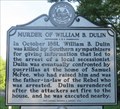 view gallery view galleryNW14.6 km | Murder of William B. Dulin in West Virginia Historical Markers William B. Dulin killed by southern sympathizers. posted by: dukemartin location: West Virginia date approved: 06/27/2020 last visited: never |
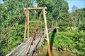 view gallery view galleryNE17.4 km |  Parker Suspension Bridge - Smithville WV Parker Suspension Bridge - Smithville WV
in Pedestrian Suspension Bridges 39.075484, -81.124464 posted by: nomadwillie location: West Virginia date approved: 12/31/2022 last visited: never |
 view gallery view gallery SE17.9 km SE17.9 km
| Engagement at Arnoldsburg Divided Loyalties - Arnoldsburg WV in Civil War Discovery Trail Sites Early in 1862, the 11th West Virginia Infantry in Spencer established an outpost here in Arnoldsburg to suppress Confederate guerilla activity. posted by: Don.Morfe location: West Virginia date approved: 08/12/2020 last visited: 10/05/2021 |
 view gallery view gallerySE17.9 km | Engagement at Arnoldsburg-Divided Loyalties - Arnoldsburg WV in U.S. Civil War Sites Early in 1862, the 11th West Virginia Infantry in Spencer established an outpost here in Arnoldsburg to suppress Confederate guerilla activity. Union Maj. George C. Trimble commanded four companies here at Camp McDonald. posted by: Don.Morfe location: West Virginia date approved: 07/01/2023 last visited: 07/01/2023 |
 view gallery view gallerySE17.9 km | Arnoldsburg Skirmish - Arnoldsburg WV in Battlefields Scene of engagement, May 6, 1862, when Federals under Maj. George C. Trimble beat off an attack by Confederate Moccasin Rangers under Capt. Geo. Downs. posted by: Don.Morfe location: West Virginia date approved: 11/21/2020 last visited: 10/16/2021 |
|