 view gallery view gallery NE3.9 km NE3.9 km
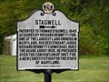
|   Stagwell Stagwell
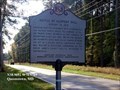
in Maryland Historical Markers Land patented in 1649 posted by:  Metaphor Metaphor location: Maryland date approved: 04/22/2006 last visited: 06/21/2007 |
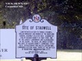 view gallery view galleryNE3.9 km | Site of Stagwell - Carmichael MD in Maryland Historical Markers Land patented in 1659 to Thomas Stagwell, English immigrant and member of the Maryland General Assembly (elected 1661). posted by:  Don.Morfe Don.Morfe location: Maryland date approved: 08/24/2021 last visited: 08/24/2021 |
 view gallery view gallery E4 km E4 km
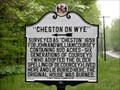
| "Cheston on Wye" in Maryland Historical Markers 1659 Survey Patent posted by: Metaphor location: Maryland date approved: 04/22/2006 last visited: 08/23/2021 |
 view gallery view gallery S4.2 km S4.2 km
|  Wye Raspberries & Blackberries Wye Raspberries & Blackberries
in Berry Picking A nice patch of raspberries and blueberries located on Wye Island State Park. posted by: ODragon location: Maryland date approved: 07/02/2008 last visited: 06/28/2008 |
 view gallery view galleryE4.2 km | "Wye Plantation" in Maryland Historical Markers Home of a Signer of the Declaration of Independence posted by: Metaphor location: Maryland date approved: 04/22/2006 last visited: never |
 view gallery view galleryE4.3 km | Wye Island in Maryland Historical Markers Wye Island -- early historical site, now managed by the State of Maryland Department of Natural Resources posted by: Metaphor location: Maryland date approved: 04/22/2006 last visited: never |
 view gallery view gallery N4.7 km N4.7 km
|  Ewing Pond Park Gazebo - Grasonville, Md. Ewing Pond Park Gazebo - Grasonville, Md.
in Gazebos A quaint gazebo in Grasonville, Md. posted by: Mother Wolf location: Maryland date approved: 10/09/2008 last visited: never |
 view gallery view galleryN4.7 km |  Ewing Pond Park - Grasonville MD Ewing Pond Park - Grasonville MD
in Municipal Parks and Plazas Ewing Pond Park-Queen Anne's County Parks and Recreation. About 15 acres of passive recreational area that includes trails, outdoor classroom areas, a gazebo, and pond. posted by: Don.Morfe location: Maryland date approved: 08/29/2022 last visited: 08/29/2022 |
 view gallery view galleryN4.7 km |  Road to Battle Star-Spangled Banner National Historic Trail - Grasonville, MD Road to Battle Star-Spangled Banner National Historic Trail - Grasonville, MD
in War of 1812 About 300 British soldiers approached Queenstown by road on August 13, 1813. Their part in a two-pronged attack involved a steamy march across Kent Island and The Narrows, towing two field cannon. posted by: Don.Morfe location: Maryland date approved: 02/24/2020 last visited: 11/02/2021 |
 view gallery view galleryN4.7 km |  Road to Battle Star-Spangled Banner National Historic Trail - Grasonville, MD Road to Battle Star-Spangled Banner National Historic Trail - Grasonville, MD
in Signs of History About 300 British soldiers approached Queenstown by road on August 13, 1813. Their part in a two-pronged attack involved a steamy march across Kent Island and The Narrows, towing two field cannon. posted by: Don.Morfe location: Maryland date approved: 08/29/2022 last visited: 08/29/2022 |
 view gallery view galleryN5 km |  Lure of Freedom Star-Spangled Banner National Historic Trail - Queenstown MD Lure of Freedom Star-Spangled Banner National Historic Trail - Queenstown MD
in Civil Rights Memorials In April of 1814, British Admiral Cochrane issued a proclamation offering slaves or free blacks service in His Majesty’s armed forces or free passage to settle in a British colony. posted by: Don.Morfe location: Maryland date approved: 03/22/2020 last visited: 10/19/2021 |
 view gallery view galleryN5 km | Lure of Freedom Star-Spangled Banner National Historic Trail - Queenstown MD in Signs of History In April of 1814, British Admiral Cochrane issued a proclamation offering slaves or free blacks service in His Majesty’s armed forces or free passage to settle in a British colony. posted by: Don.Morfe location: Maryland date approved: 08/30/2022 last visited: 08/31/2022 |
 view gallery view galleryN5 km | British Command Star-Spangled Banner National Historic Trail - Queenstown MD in Signs of History The British invaded Kent Island on August 5, 1813. British Rear Admiral George Cockburn of the Royal Navy planned an attack on Queenstown by land and water, a pincer attack. posted by: Don.Morfe location: Maryland date approved: 08/30/2022 last visited: 08/31/2022 |
 view gallery view galleryN5 km | British Command Star-Spangled Banner National Historic Trail - Queenstown MD in War of 1812 The British invaded Kent Island on August 5, 1813. British Rear Admiral George Cockburn of the Royal Navy planned an attack on Queenstown by land and water, a pincer attack. posted by: Don.Morfe location: Maryland date approved: 03/15/2020 last visited: 11/02/2021 |
 view gallery view galleryN5 km | Protecting the Homefront Star-Spangled Banner Historic Trail - Queenstown MD in War of 1812 Following the Chesapeake and Leopard affair in 1807 where American sailors were impressed into British service, there was outrage on the Eastern Shore. posted by: Don.Morfe location: Maryland date approved: 03/17/2020 last visited: 11/02/2021 |
 view gallery view galleryN5 km | Protecting the Homefront Star-Spangled Banner Historic Trail - Queenstown MD in Signs of History Following the Chesapeake and Leopard affair in 1807 where American sailors were impressed into British service, there was outrage on the Eastern Shore. posted by: Don.Morfe location: Maryland date approved: 08/30/2022 last visited: 08/31/2022 |
 view gallery view galleryN5 km | The Battle Enjoined! Star-Spangled Banner Historic Trail - Queenstown MD in Signs of History On the night of August 13, 300 British troops marched towards Queenstown where a large American militia force was said to be encamped. posted by: Don.Morfe location: Maryland date approved: 08/30/2022 last visited: 08/31/2022 |
 view gallery view galleryN5 km | The Battle Enjoined! Star-Spangled Banner Historic Trail - Queenstown MD in War of 1812 On the night of August 13, 300 British troops marched towards Queenstown where a large American militia force was said to be encamped. posted by: Don.Morfe location: Maryland date approved: 03/14/2020 last visited: 11/02/2021 |
 view gallery view gallery NW5.1 km NW5.1 km
|  Turtle Crossing - CBEC, Grasonville, Md. Turtle Crossing - CBEC, Grasonville, Md.
in Turtle Crossings This is a frequently used spot for our turtles to cross the road from one part of the marsh area to another. posted by: Mother Wolf location: Maryland date approved: 10/25/2008 last visited: 06/03/2011 |
 view gallery view galleryN5.3 km |  Battle of Slippery Hill-August 13, 1813 - Queenstown MD Battle of Slippery Hill-August 13, 1813 - Queenstown MD
in Battlefields Battle of Slippery Hill August 13, 1813 (War of 1812)-American Videttes skirmished with approximately 300 British troops under the command of Col. Sir Thomas Sidney Beckwith. posted by: Don.Morfe location: Maryland date approved: 10/17/2022 last visited: 10/16/2022 |
 view gallery view galleryN5.3 km | Battle of Slippery Hill-August 13, 1813 in Maryland Historical Markers Battle of Slippery Hill August 13, 1813-American Videttes skirmished with approximately 300 British troops under the command of Col. Sir Thomas Sidney Beckwith. posted by: Don.Morfe location: Maryland date approved: 10/25/2019 last visited: 09/28/2021 |
 view gallery view galleryNW5.5 km |  Denny's - VFW Drive - Grasonville, Maryland Denny's - VFW Drive - Grasonville, Maryland
in Denny's Restaurants Located at exit 44A along the west bound side of Route 50. posted by: flyingmoose location: Maryland date approved: 10/16/2020 last visited: 12/30/2023 |
 view gallery view galleryNW5.5 km |  M60 Patton Tank - Graysonville, Maryland M60 Patton Tank - Graysonville, Maryland
in Military Ground Equipment Displays A M60 Patton Tank at the Graysonville VFW. posted by: flyingmoose location: Maryland date approved: 10/15/2020 last visited: never |
 view gallery view galleryNW5.6 km |  CBEC - Grasonville, Md. CBEC - Grasonville, Md.
in Birdwatching Locations CBEC - Chesapeake Bay Environmental Center. This is a bird & waterfowl preserve located off of the Chesapeake Bay, Md. posted by: Mother Wolf location: Maryland date approved: 10/09/2008 last visited: 04/18/2009 |
 view gallery view galleryNW6 km |  CBEC Boardwalk - Grasonville, MD CBEC Boardwalk - Grasonville, MD
in Eagle Scout Project Sites Boardwalk leading to an observation platform. posted by: DudleyGrunt location: Maryland date approved: 04/20/2009 last visited: 07/18/2019 |
|