 view gallery view gallery E8.7 km E8.7 km
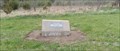
|   Memory Vault - Lawrence, KS Memory Vault - Lawrence, KS
in Time Capsules This time capsule is in Sesquicentennial Point Park, southwest of Lawrence, Kansas. posted by:  The Snowdog The Snowdog location: Kansas date approved: 05/05/2022 last visited: never |
 view gallery view gallery N8.7 km N8.7 km
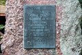
|  Oregon Trail - 1842 - Coon Point - Kanwaka, KS Oregon Trail - 1842 - Coon Point - Kanwaka, KS
in Kansas Historical Markers Located on US 40 in wayside park. posted by: Markerman62 location: Kansas date approved: 11/16/2021 last visited: never |
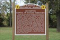 view gallery view galleryN8.7 km | Lecompton Capital of Kansas Territory - Kanwaka, KS in Kansas Historical Markers Located on US 40 in wayside park. posted by: Markerman62 location: Kansas date approved: 11/16/2021 last visited: never |
 view gallery view galleryE8.7 km |  Historic Kansas (1860-2003) - Lawrence, KS Historic Kansas (1860-2003) - Lawrence, KS
in Timelines This timeline covers historic Kansas from 1869 to 2003 - in Sesquicentennial Point Park, southwest of Lawrence, Kansas. posted by: The Snowdog location: Kansas date approved: 05/07/2022 last visited: never |
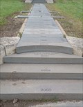 view gallery view galleryE8.7 km |  Historic Kansas (1860-2003) - Lawrence, KS Historic Kansas (1860-2003) - Lawrence, KS
in Donated Engraved Bricks and Pavers This timeline, constructed of engraved pavers, covers historic Kansas from 1869 to 2003 - in Sesquicentennial Point Park, southwest of Lawrence, Kansas. posted by: The Snowdog location: Kansas date approved: 05/05/2022 last visited: never |
 view gallery view gallery SE12.6 km SE12.6 km
|  Jacobs - Colyar Cemetery - Rural Douglas County, KS Jacobs - Colyar Cemetery - Rural Douglas County, KS
in Zinc Headstones This very unusual marker is located in a very peaceful hilltop cemetery in rural Douglas County, Kansas. posted by: iconions location: Kansas date approved: 02/16/2009 last visited: never |
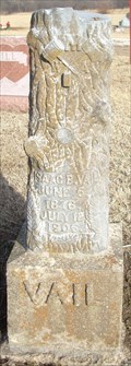 view gallery view gallery W12.9 km W12.9 km
|  Isaac Vail - Mount Pleasant Cemetery - Shawnee County, Ks Isaac Vail - Mount Pleasant Cemetery - Shawnee County, Ks
in Woodmen of the World Grave Markers/Monuments This Modern Woodman of America marker is located in the Mount Pleasant Cemetery - SE 85th and SE Ratner in rural Shawnee County. posted by: iconions location: Kansas date approved: 08/08/2009 last visited: never |
 view gallery view gallery NW13 km NW13 km
|  Lawrence 18 Miles East Map - Tecumseh, KS Lawrence 18 Miles East Map - Tecumseh, KS
in 'You Are Here' Maps This is one of 5 maps at this same location. posted by: bluesnote location: Kansas date approved: 07/26/2015 last visited: 07/26/2015 |
 view gallery view galleryNW13 km | Topeka 10 Miles West Map - Tecumseh, KS in 'You Are Here' Maps This is one of 5 maps at this same location. posted by: bluesnote location: Kansas date approved: 07/26/2015 last visited: 07/26/2015 |
 view gallery view galleryNW13 km | Wamego 54 Miles West Map - Tecumseh, KS in 'You Are Here' Maps This is one of 5 maps at this same location. posted by: bluesnote location: Kansas date approved: 07/26/2015 last visited: 07/26/2015 |
 view gallery view galleryNW13 km | Emporia 67 Miles Southwest Map - Tecumseh, KS in 'You Are Here' Maps This is one of 5 maps at this same location. posted by: bluesnote location: Kansas date approved: 07/26/2015 last visited: 07/26/2015 |
 view gallery view galleryNW13 km | Native Stone Map - Tecumseh, KS in 'You Are Here' Maps This is one of 5 maps at this same location. posted by: bluesnote location: Kansas date approved: 07/26/2015 last visited: 07/26/2015 |
 view gallery view galleryNW13 km |  Hardee's - Interstate 70 - Tecumseh, KS Hardee's - Interstate 70 - Tecumseh, KS
in Wi-Fi Hotspots Hardee's free wifi. posted by: bluesnote location: Kansas date approved: 08/02/2015 last visited: 08/02/2015 |
 view gallery view galleryNW13 km |  Pizza Hut - Interstate 70 - Tecumseh, KS Pizza Hut - Interstate 70 - Tecumseh, KS
in Pizza Hut Restaurants A food court at a rest area along I-70. posted by: bluesnote location: Kansas date approved: 07/27/2015 last visited: 07/27/2015 |
 view gallery view galleryNW13 km |  Taco Bell - Interstate 70 - Tecumseh, KS Taco Bell - Interstate 70 - Tecumseh, KS
in Taco Bell Restaurants A food court at a rest area along I-70. posted by: bluesnote location: Kansas date approved: 07/27/2015 last visited: 07/27/2015 |
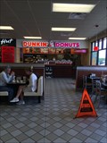 view gallery view galleryNW13 km |  Dunkin Donuts - Interstate 70 - Tecumseh, KS Dunkin Donuts - Interstate 70 - Tecumseh, KS
in Dunkin Donuts' A food court at a rest area along I-70. posted by: bluesnote location: Kansas date approved: 07/27/2015 last visited: 07/27/2015 |
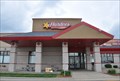 view gallery view galleryNW13 km |  Hardee's - I-70 Westbound Service Plaza ~ Tecumseh, Kansas Hardee's - I-70 Westbound Service Plaza ~ Tecumseh, Kansas
in Carl's Jr./Hardee's Restaurants This Hardee's outlet is located in the Westbound Service Plaza on Interstate Highway 70 at milepost 188 in Tecumseh, Kansas. posted by: brwhiz location: Kansas date approved: 02/21/2013 last visited: 07/22/2015 |
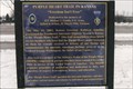
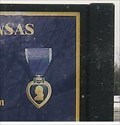 view gallery view galleryNW13.2 km |  Purple Heart Trail in Kansas - Douglas County, KS Purple Heart Trail in Kansas - Douglas County, KS
in George Washington One of 32 markers or signs, each dedicated to a different MOPH recipient. posted by: YoSam. location: Kansas date approved: 05/03/2019 last visited: 09/30/2021 |
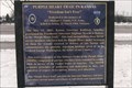 view gallery view galleryNW13.2 km |  Purple Heart Trail Now Goes Through Kansas Purple Heart Trail Now Goes Through Kansas
in News Article Locations One of 32 markers or signs, each dedicated to a different MOPH recipient. posted by: YoSam. location: Kansas date approved: 04/28/2019 last visited: 09/30/2021 |
 view gallery view galleryNW13.2 km | Purple Heart Trail in Kansas - Douglas County, KS in Kansas Historical Markers One of 32 markers or signs, each dedicated to a different MOPH recipient. posted by: YoSam. location: Kansas date approved: 03/22/2015 last visited: 09/30/2021 |
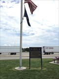
 view gallery view galleryNW13.2 km |  1st Lt. Michael L. Gandy - Douglas County, KS 1st Lt. Michael L. Gandy - Douglas County, KS
in Specific Veteran Memorials 1Lt. Michael L. Gandy, U.S. Army; Killed In Action, 29 March 1968, Vietnam. One of 32 markers or signs, each dedicated to a different MOPH recipient. posted by: YoSam. location: Kansas date approved: 03/22/2015 last visited: 09/30/2021 |
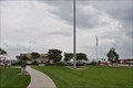 view gallery view galleryNW13.2 km |  Topeka Interstate 70 Westbound Service Plaza Topeka Interstate 70 Westbound Service Plaza
in Highway Rest Areas This Service Plaza is located on westbound Interstate Highway 70 at milepost 188 in Tecumseh, Kansas. posted by: brwhiz location: Kansas date approved: 02/22/2013 last visited: 09/14/2019 |
 view gallery view galleryNW13.2 km |  Topeka Service Plaza - Tecumseh, KS Topeka Service Plaza - Tecumseh, KS
in Free Overnight RV Parking Locations A rest stop between Kansas City and Topeka on Interstate 70. posted by: bluesnote location: Kansas date approved: 02/20/2016 last visited: 02/20/2016 |
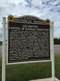 view gallery view galleryNW13.2 km |  Lecompton Capital of Kansas Territory - Tecumseh, KS Lecompton Capital of Kansas Territory - Tecumseh, KS
in Civil Rights Memorials A marker that talks about the beginnings of the Lincoln-Douglas debates. posted by: bluesnote location: Kansas date approved: 04/03/2016 last visited: 04/03/2016 |
 view gallery view galleryNW13.2 km |  Lecompton Capital of Kansas Territory - Tecumseh, KS Lecompton Capital of Kansas Territory - Tecumseh, KS
in U.S. 40 - The National Road Located at a rest area long Interstate 70, just east of Topeka. posted by: bluesnote location: Kansas date approved: 07/30/2015 last visited: 07/30/2015 |
|