 view gallery view gallery NE0.5 km NE0.5 km
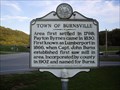
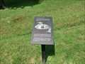
|   Town of Burnsville Town of Burnsville
in West Virginia Historical Markers Tells how Burnsville got its name. posted by:  Paintedwarrior Paintedwarrior location: West Virginia date approved: 08/14/2012 last visited: 08/18/2012 |
 view gallery view gallery E1 km E1 km
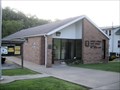
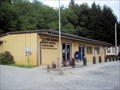
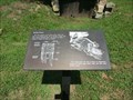
|  Burnsville, WV. 26335 Burnsville, WV. 26335
in U.S. Post Offices Burnsville WV Post Office posted by: dukemartin location: West Virginia date approved: 08/15/2012 last visited: never |
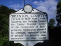 view gallery view gallery NW4 km NW4 km
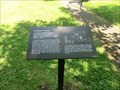
| Braxton County / Gilmer County in West Virginia Historical Markers A two sided sign at the county line. Tells where the counties were formed from and some early facts. posted by: Paintedwarrior location: West Virginia date approved: 08/14/2012 last visited: 08/18/2012 |
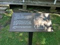
 view gallery view galleryNE9 km |  West Virginia Rest Area I-79 MM85 Northbound near Burnsville, WV West Virginia Rest Area I-79 MM85 Northbound near Burnsville, WV
in Highway Rest Areas This rest area was remodeled and reopened in 2009. It is located on I-79 heading north at mile marker 85. posted by: xptwo location: West Virginia date approved: 06/21/2012 last visited: 06/13/2018 |
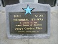 view gallery view galleryNE9 km |  Interstate 79, NB Rest Area - near Burnsville, WV Interstate 79, NB Rest Area - near Burnsville, WV
in Blue Star Memorial Highway Markers Placed at a recently built rest center is this Blue Star Highway Marker. It is located on the Northbound side of Interstate 79. Ample parking, picnic table and of course washrooms are all available as this 2009 built building. posted by: The Blue Quasar location: West Virginia date approved: 08/01/2010 last visited: 06/13/2018 |
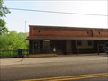
 view gallery view galleryNW9.8 km | Sand Fork, WV. 26430 in U.S. Post Offices Sand Fork WV Post Office posted by: dukemartin location: West Virginia date approved: 08/15/2012 last visited: never |
 view gallery view gallery SE10.6 km SE10.6 km
| Skirmish at Salt Lick Bridge in West Virginia Historical Markers An overview of a skirmish between Union and Confederate forces. posted by: dukemartin location: West Virginia date approved: 06/21/2024 last visited: never |
 view gallery view gallery S10.6 km S10.6 km
| Heater, WV 26627 Post Office in U.S. Post Offices Heater, WV 26627 Post Office posted by: dukemartin location: West Virginia date approved: 06/13/2015 last visited: never |
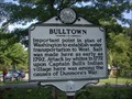 view gallery view gallerySE11.4 km | Bulltown / Bulltown Battle in West Virginia Historical Markers A two sided sign telling us about some battles that occurred near here. posted by: Paintedwarrior location: West Virginia date approved: 09/04/2013 last visited: 08/05/2014 |
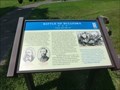
 view gallery view gallerySE11.4 km |  Battle of Bulltown-"Come and take us" - Napier WV Battle of Bulltown-"Come and take us" - Napier WV
in U.S. Civil War Sites On October 13, Confederate Col. William L. “Mudwall” Jackson attacked the fortifications at 4:30 A.M. with about 700 men of the 19th and 20 Virginia Cavalry and two guns of Capt. Warren S. Lurty’s battery. posted by:  Don.Morfe Don.Morfe location: West Virginia date approved: 07/05/2023 last visited: 07/05/2023 |
 view gallery view gallerySE11.4 km |  Battle of Bulltown - Napier WV Battle of Bulltown - Napier WV
in Battlefields On October 13, Confederate Col. William L. “Mudwall” Jackson attacked the fortifications at 4:30 A.M. with about 700 men of the 19th and 20 Virginia Cavalry and two guns of Capt. Warren S. Lurty’s battery. posted by: Don.Morfe location: West Virginia date approved: 11/21/2020 last visited: 10/16/2021 |
 view gallery view gallerySE11.4 km | Battle of Bulltown- "Come and take us" - Napier WV in Civil War Discovery Trail Sites On the hill in front of you are two fortifications that Union Gen. George B. McClellan ordered constructed late in1861. They guarded the wooden covered bridge located here on the Weston and Gauley Bridge Turnpike. posted by: Don.Morfe location: West Virginia date approved: 08/12/2020 last visited: 10/05/2021 |
 view gallery view gallerySE11.4 km |  Coal-and-Wood House-Bulltown Historic District - Napier WV Coal-and-Wood House-Bulltown Historic District - Napier WV
in Signs of History The coal-and-wood house, a rectangular building constructed of rough saw-mill lumber, stood here. After the introduction of gas heating, the building was used for general storage. posted by: Don.Morfe location: West Virginia date approved: 11/19/2020 last visited: 09/24/2021 |
 view gallery view gallerySE11.4 km | Spring House-Bulltown Historic District - Napier WV in Signs of History The main purpose of the spring house, which was built over a natural spring, was to provide a family with fresh, sanitary drinking water. The water was either pumped or dipped by hand, as needed. posted by: Don.Morfe location: West Virginia date approved: 11/19/2020 last visited: 09/24/2021 |
 view gallery view gallerySE11.4 km | Cunningham Farmstead-Bulltown Historic District - Napier WV in Signs of History In time the Cunninghams built a granary, barns, coal-and-wood house, outhouse, and chicken house, in addition to the main house, to form a traditional central West Virginia subsistence farm. posted by: Don.Morfe location: West Virginia date approved: 11/19/2020 last visited: 09/24/2021 |
 view gallery view gallerySE11.4 km | Cunningham House-Bulltown Historic District - Napier WV in Signs of History Named for Henry Cunningham, the Cunningham House was owned by the Cunningham family from the time it was built in the nineteenth century until 1976, when it was purchased by the U.S. Army Corps of Engineers. posted by: Don.Morfe location: West Virginia date approved: 11/19/2020 last visited: 09/24/2021 |
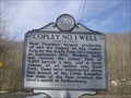 view gallery view gallery N12.7 km N12.7 km
| Copley No. 1 Well in West Virginia Historical Markers A sign telling us about the largest oil producing well in West Virginia. posted by: Paintedwarrior location: West Virginia date approved: 02/08/2016 last visited: 02/09/2016 |
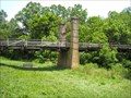 view gallery view galleryNW13.2 km |  Duck Run Suspension Bridge Duck Run Suspension Bridge
in Suspension Bridges This small, rural suspension bridge was closed to automobile traffic in 1992 and placed on the National Register of Historic Places in 1997. posted by: Helldivers location: West Virginia date approved: 06/18/2011 last visited: never |
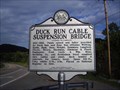 view gallery view galleryNW13.2 km | Duck Run Cable Suspension Bridge in West Virginia Historical Markers Tells who helped to maintain the bridge and that it was placed on the National Register in 1997. posted by: Paintedwarrior location: West Virginia date approved: 08/14/2012 last visited: 08/18/2012 |
 view gallery view galleryS15 km | Flatwoods West Virginia 26621 in U.S. Post Offices A scenic mile N. of the fast food joints on US 19 at I-79 is a modern ranch style post office in the old town. 308 Flatwoods Corner Road Flatwoods West Virginia 26621 Town is usually known for the Flatwoods Monster UFO Incident on 9/12/52. posted by: mars888 location: West Virginia date approved: 06/14/2013 last visited: 10/05/2008 |
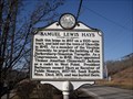 view gallery view galleryNW16.3 km | Samuel Lewis Hays in West Virginia Historical Markers Tell about Samuel Lewis Hays who laid out the town of Glenville, WV in 1845. posted by: Paintedwarrior location: West Virginia date approved: 03/11/2013 last visited: 03/16/2013 |
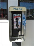 view gallery view galleryS16.9 km |  Sunoco payphone - I-79 Exit 67 - Flatwoods, WV Sunoco payphone - I-79 Exit 67 - Flatwoods, WV
in Payphones Gas station payphone at exit with outlet mall posted by: vhasler location: West Virginia date approved: 05/03/2009 last visited: 05/03/2014 |
 view gallery view galleryNW16.9 km | Glenville State Teachers College in West Virginia Historical Markers A central West Virginia college maintained for the training of grade and high school teachers. posted by: Paintedwarrior location: West Virginia date approved: 03/11/2013 last visited: 03/16/2013 |
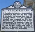 view gallery view galleryNW16.9 km | The Gilmer Rifles in West Virginia Historical Markers Company D, "The Gilmer Rifles" saw action in three Civil War battles. posted by: dukemartin location: West Virginia date approved: 07/11/2020 last visited: never |
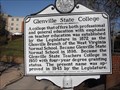 view gallery view galleryNW17.1 km | Glenville State College in West Virginia Historical Markers A sign telling about the type of education offered here. posted by: Paintedwarrior location: West Virginia date approved: 03/11/2013 last visited: 03/16/2013 |
|