 view gallery view gallery NE1.6 km NE1.6 km
|   Centenary United Methodist Churchyard Cemetery - Shady Side MD Centenary United Methodist Churchyard Cemetery - Shady Side MD
in Worldwide Cemeteries The churchyard cemetery is in front and on the side of the Centenary United Methodist Church. It is very small. It is located at 6248 Shady Side Road, Shady Side MD 20764 posted by:  Don.Morfe Don.Morfe location: Maryland date approved: 05/30/2022 last visited: 05/28/2022 |
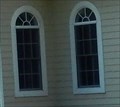 view gallery view galleryNE1.6 km |  Stained Glass Windows at Centenary United Methodist Church - Shady Side MD Stained Glass Windows at Centenary United Methodist Church - Shady Side MD
in Stained Glass Windows There are several stained glass windows in the front and sides of the Centenary United Methodist Church posted by: Don.Morfe location: Maryland date approved: 05/28/2022 last visited: 05/28/2022 |
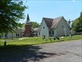 view gallery view galleryNE1.6 km |  Centenary United Methodist Churchyard Cemetery - Shady Side MD Centenary United Methodist Churchyard Cemetery - Shady Side MD
in Churchyard Cemeteries The churchyard cemetery is in front and on the side of the Centenary United Methodist Church. It is very small. It is located at 6248 Shady Side Road, Shady Side MD 20764 posted by: Don.Morfe location: Maryland date approved: 05/30/2022 last visited: 05/28/2022 |
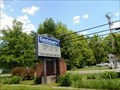
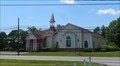
 view gallery view galleryNE1.6 km |  Centenary United Methodist Church - Shady Side MD Centenary United Methodist Church - Shady Side MD
in Methodist Churches On October 5, 2003, World Communion Sunday, was the first service held in the re-built Centenary United Methodist Church. The church has a cemetery on its grounds. posted by: Don.Morfe location: Maryland date approved: 05/28/2022 last visited: 05/28/2022 |
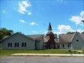
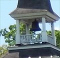 view gallery view galleryNE1.6 km |  Bell Tower at Centenary United Methodist Church - Shady Side MD Bell Tower at Centenary United Methodist Church - Shady Side MD
in Bell Towers The bell tower is over the front door of Centenary United Methodist Church. The base of the tower is red brick. posted by: Don.Morfe location: Maryland date approved: 05/28/2022 last visited: 05/28/2022 |
 view gallery view gallery E1.6 km E1.6 km
| St. Matthews United Methodist Church - Shady Side MD in Methodist Churches On Oct. 22, 1887 the deed shows the first parcel of land was deeded to the trustees of St. Matthews Methodist Episcopal Church. St. Matthews UMC held its first service in the new sanctuary on Sunday, Feb. 12, 2012. posted by: Don.Morfe location: Maryland date approved: 05/28/2022 last visited: 05/28/2022 |
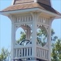 view gallery view galleryE1.6 km | Bell Tower at St. Matthews United Methodist Church - Shady Side MD in Bell Towers The bell tower is above the front door of the St. Matthews United Methodist Church. It has one bell in it. posted by: Don.Morfe location: Maryland date approved: 05/28/2022 last visited: 05/28/2022 |
 view gallery view gallery NW1.8 km NW1.8 km
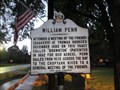
|  William Penn attended a meeting William Penn attended a meeting
in Maryland Historical Markers Maryland Historical Marker concerning William Penn. posted by:  LeGrandChrist LeGrandChrist location: Maryland date approved: 08/30/2014 last visited: 08/12/2014 |
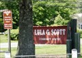 view gallery view galleryE1.8 km |  Lula G. Scott Community Center - Shady Side MD Lula G. Scott Community Center - Shady Side MD
in Wikipedia Entries The Lula G. Scott Community Center is a historic site located in Anne Arundel County. It now consists of two frame buildings that were built as Rosenwald Schools. The Churchton School was constructed in 1921 and the Shady Side School in 1926. posted by: Don.Morfe location: Maryland date approved: 05/21/2022 last visited: 05/21/2022 |
 view gallery view galleryE1.8 km |  Former Rosenwald Schools - Shady Side MD Former Rosenwald Schools - Shady Side MD
in Former Schools The Lula G. Scott Community Center is a historic site located in Anne Arundel County. It now consists of two frame buildings that were built as Rosenwald Schools. The Churchton School was constructed in 1921 and the Shady Side School in 1926. posted by: Don.Morfe location: Maryland date approved: 05/21/2022 last visited: 05/21/2022 |
 view gallery view galleryE1.8 km |  Scott, Lula G., Community Center - Shady Side MD Scott, Lula G., Community Center - Shady Side MD
in U.S. National Register of Historic Places The Lula G. Scott Community Center consists of the combined Shady Side and Churchton Rosenwald Schools and two 1950s additions. The Shady Side Rosenwald School was constructed in this location in 1926. posted by: Don.Morfe location: Maryland date approved: 05/22/2022 last visited: 05/21/2022 |
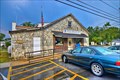 view gallery view galleryNW1.9 km |  Galesville, MD 20765 Galesville, MD 20765
in U.S. Post Offices Located at 948 Galesville Road Galesville, MD posted by: nomadwillie location: Maryland date approved: 10/02/2013 last visited: never |
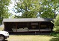 view gallery view galleryNE2.7 km |  Edna Florence Chesapeake Bay deadrise workboat - Shady Side MD Edna Florence Chesapeake Bay deadrise workboat - Shady Side MD
in Landlocked Boats 0n the property of the Captain Salem Avery Museum is a modern boathouse built in 1993 that features the Edna Florence, a locally-built Chesapeake Bay deadrise workboat. posted by: Don.Morfe location: Maryland date approved: 05/20/2022 last visited: 05/21/2022 |
 view gallery view galleryNE2.7 km | Captain Avery Museum - Shady Side MD in Wikipedia Entries The Captain Avery Museum is a historic home and museum at Shady Side, Anne Arundel County. The two-story historic structure originally was the residence of the Chesapeake Bay waterman, Capt. Salem Avery, and was constructed about 1860. posted by: Don.Morfe location: Maryland date approved: 05/20/2022 last visited: 05/21/2022 |
 view gallery view galleryNE2.9 km |  Captain Avery Museum - Shady Side MD Captain Avery Museum - Shady Side MD
in Maritime Museums The Captain Avery Museum is a historic home and museum at Shady Side, Anne Arundel County. The two-story historic structure originally was the residence of the Chesapeake Bay waterman, Capt. Salem Avery, and was constructed about 1860. posted by: Don.Morfe location: Maryland date approved: 05/20/2022 last visited: 05/21/2022 |
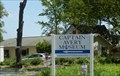 view gallery view galleryNE2.9 km | Avery, Capt. Salem, House - Shady Side MD in U.S. National Register of Historic Places The Captain Salem Avery House is significant for its association with the maritime history and recreational development of the Chesapeake Bay region. posted by: Don.Morfe location: Maryland date approved: 05/22/2022 last visited: 05/21/2022 |
 view gallery view galleryNE2.9 km | Shady Side, Maryland in Wikipedia Entries The GPS coordinates are for the Capt. Salem Avery House. Shady Side is a census-designated place (CDP) in Anne Arundel County, Maryland, United States. The population was 5,803 at the 2010 census. posted by: Don.Morfe location: Maryland date approved: 05/29/2024 last visited: 05/29/2024 |
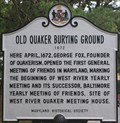 view gallery view galleryNW3.1 km | Old Quaker Burying Ground in Maryland Historical Markers Old Quaker Burying Ground historical marker, first general meeting of Friends in Maryland, 1672 posted by: geotrooperz-pp location: Maryland date approved: 07/16/2012 last visited: 07/11/2012 |
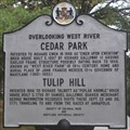 view gallery view galleryNW3.1 km | Cedar Park and Tulip Hill in Maryland Historical Markers CEDAR PARK and TULIP HILL Historical Marker posted by: geotrooperz-pp location: Maryland date approved: 07/26/2012 last visited: 07/11/2012 |
 view gallery view galleryNW5.5 km | William Penn visited his quaker friend in Maryland Historical Markers Maryland Historical Marker concerning William Penn. posted by: LeGrandChrist location: Maryland date approved: 08/30/2014 last visited: 08/12/2014 |
 view gallery view gallery W5.6 km W5.6 km
|  4778 Sudley Road-Owensville Historic District – Owensville MD 4778 Sudley Road-Owensville Historic District – Owensville MD
in NRHP Historic Districts - Contributing Buildings The rural setting of Owensville is located at the intersection of two important rural roads. It is representative of the 19th century crossroads communities. Included in the district is 4778 Sudley Road. posted by: Don.Morfe location: Maryland date approved: 05/28/2022 last visited: 05/28/2022 |
 view gallery view galleryNW5.8 km | Tobacco Barn, 249 Owensville Road-Owensville Historic District – Owensville MD in NRHP Historic Districts - Contributing Buildings The rural setting of Owensville is located at the intersection of two important rural roads. It is representative of the 19th century crossroads communities. Included in the district is a Tobacco Barn at 249 Owensville Rd. posted by: Don.Morfe location: Maryland date approved: 05/28/2022 last visited: 05/28/2022 |
 view gallery view galleryNW6 km | Christ Church Rectory-Owensville Historic District – Owensville MD 20778 in NRHP Historic Districts - Contributing Buildings The rural setting of Owensville is located at the intersection of two important rural roads. It is representative of the 19th century crossroads communities. Included in the district is Christ Church Rectory. posted by: Don.Morfe location: Maryland date approved: 05/28/2022 last visited: 05/28/2022 |
 view gallery view galleryNW6 km | Owensville, Maryland in Wikipedia Entries The GPS coordinates are for Christ Church or Christ Episcopal Church. It is an historic Carpenter Gothic style Episcopal church at Owensville, Anne Arundel County, Maryland, United States. posted by: Don.Morfe location: Maryland date approved: 05/29/2024 last visited: 05/29/2024 |
 view gallery view galleryNW6 km | Christ Church (Owensville, Maryland) in Wikipedia Entries Christ Church, or Christ Episcopal Church, West River, is an historic Carpenter Gothic style Episcopal church at Owensville, Anne Arundel County, Maryland, United States. posted by: Don.Morfe location: Maryland date approved: 05/26/2022 last visited: 05/27/2022 |
|