 view gallery view gallery NW0.3 km NW0.3 km
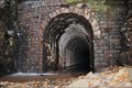
|   Tunnel #2, Glady WV Tunnel #2, Glady WV
in Abandoned Train Tunnels Abandoned Tunnel #2 in Glady West Virginia posted by:  eightwednesday eightwednesday location: West Virginia date approved: 03/09/2012 last visited: 08/31/2018 |
 view gallery view gallery N7.1 km N7.1 km
|  Peter Shaver Peter Shaver
in American Revolutionary War Veteran Graves Found on a small back country road leading to the town of Glady, this single gravesite is also a memorial to this Revolutionary War Patriot. posted by: SerenityNow location: West Virginia date approved: 11/03/2007 last visited: 08/31/2018 |
 view gallery view gallery SE8 km SE8 km
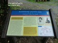
|  95 EA at 3169ft - Randolph County, WV 95 EA at 3169ft - Randolph County, WV
in U.S. Benchmarks Monumented. Excellent condition. posted by:  BURKOWSKI BURKOWSKI location: West Virginia date approved: 04/18/2008 last visited: never |
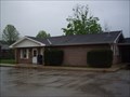
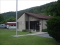 view gallery view galleryN12.4 km |  Bowden, WV 26254 Bowden, WV 26254
in U.S. Post Offices Bowden WV 26254 Post Office posted by: dukemartin location: West Virginia date approved: 06/06/2012 last visited: never |
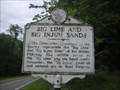 view gallery view galleryN12.6 km |  Big Lime And Big Injun Sands Big Lime And Big Injun Sands
in West Virginia Historical Markers A sign describing the products that the limestone yielded. posted by: Paintedwarrior location: West Virginia date approved: 08/11/2013 last visited: 08/12/2013 |
 view gallery view gallery W13.8 km W13.8 km
| Stalnaker Cabin Site & Cemetery in West Virginia Historical Markers Jacob Stalnaker built a log cabin nearby in 1795, one of the earliest in Randolph County. posted by: Paintedwarrior location: West Virginia date approved: 07/01/2013 last visited: 07/06/2013 |
 view gallery view galleryW14 km | Beverly, WV. 26253 in U.S. Post Offices Beverly WV 26253, Post Office posted by: dukemartin location: West Virginia date approved: 05/13/2013 last visited: never |
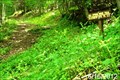 view gallery view gallery E14.2 km E14.2 km
|  Spring Ridge Trail - Seneca Creek Backcountry - Monongahala National Forest - Western, West Virginia Spring Ridge Trail - Seneca Creek Backcountry - Monongahala National Forest - Western, West Virginia
in Hiking and walking trailheads The Spring Ridge Trail is located in the Seneca Creek Backcounty of the Monongahela National Forest in West Virginia. This trail connects County Route 29 to the Allegheny Mountain Trail. posted by: outdoorboy34 location: West Virginia date approved: 06/30/2012 last visited: never |
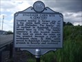
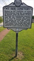 view gallery view galleryW14.2 km | Mt. Iser Cemetery / Rosser's Raid in West Virginia Historical Markers A two sided sign.
Graves of people killed during the civil war near here and the last major civil war action in the county. posted by: dukemartin location: West Virginia date approved: 06/26/2023 last visited: never |
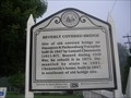
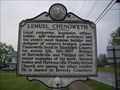 view gallery view galleryW14.2 km | Lemuel Chenoweth in West Virginia Historical Markers West Virginia's most famous builder and designer of covered bridges. posted by: Paintedwarrior location: West Virginia date approved: 05/16/2013 last visited: 05/18/2013 |
 view gallery view galleryE14.2 km | Horton Trail - Seneca Creek Backcountry - Monongahala National Forest - Whitmer, West Virginia in Hiking and walking trailheads The Horton Trail is one of several trails accessible from County Route 29 in the Seneca Creek Backcountry in the Monongahela National Forest in Randolph County, West Virginia. posted by: outdoorboy34 location: West Virginia date approved: 06/30/2012 last visited: never |
 view gallery view galleryW14.3 km |  Randolph County Jail-Confining the "Bogus State Sheriff" - Beverly WV Randolph County Jail-Confining the "Bogus State Sheriff" - Beverly WV
in U.S. Civil War Sites On the morning of April 24, 1863, Confederate Capt. Joseph French Harding, Co. F, 31st Virginia Infantry, led a scouting party from Gen. John D. Imboden’s command toward Beverly. posted by: Don.Morfe location: West Virginia date approved: 07/03/2023 last visited: 07/03/2023 |
 view gallery view galleryW14.3 km | Randolph County Jail-Confining the "Bogus State Sheriff" - Beverly WV in Civil War Discovery Trail Sites Encountering Sheriff Jesse Frank Phares on the same mission for the town’s Union Garrison, Harding fired and wounded Phares as he fled back to Beverly. posted by: Don.Morfe location: West Virginia date approved: 08/12/2020 last visited: 10/05/2021 |
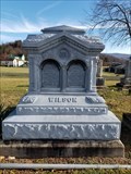 view gallery view galleryW14.3 km |  Charlotte Lee Wilson - Beverly - WV Charlotte Lee Wilson - Beverly - WV
in Zinc Headstones Double panel zinc headstone for Charlotte Lee Wilson, daughter of longtime Randolph County Clerk, James D. Wilson. posted by: wv-yen location: West Virginia date approved: 08/06/2020 last visited: never |
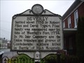 view gallery view galleryW14.3 km | Beverly in West Virginia Historical Markers Beverly settled in 1753 by Files and Tygart familes. posted by: Paintedwarrior location: West Virginia date approved: 05/16/2013 last visited: 05/11/2013 |
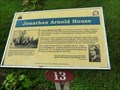 view gallery view galleryW14.3 km |  Jonathan Arnold House - Beverly WV Jonathan Arnold House - Beverly WV
in Signs of History Laura Jackson Arnold, sister of Thomas "Stonewall" Jackson, lived here at the time of the Civil War with her husband Jonathan and three children, Thomas, Anna, and Stark. posted by: Don.Morfe location: West Virginia date approved: 08/11/2020 last visited: 09/26/2021 |
 view gallery view galleryW14.3 km | David Goff House - Beverly WV in Signs of History Edward Hart, son of John Hart who was a signer of the Declaration of Independence, purchased the house standing here in 1795. Col. David Goff, a prominent Beverly lawyer, purchased it in 1830. posted by: Don.Morfe location: West Virginia date approved: 08/11/2020 last visited: 09/26/2021 |
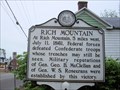 view gallery view galleryW14.3 km | Rich Mountain / Crozet-Chenoweth in West Virginia Historical Markers Directing you to the battle field 5 miles west of this location where Federal Troops defeated Confederate troops. posted by: Paintedwarrior location: West Virginia date approved: 05/11/2012 last visited: 05/13/2012 |
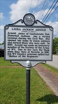 view gallery view galleryW14.3 km | Laura Jackson Arnold in West Virginia Historical Markers Laura Jackson, sister of General Stonewall Jackson posted by: dukemartin location: West Virginia date approved: 06/26/2023 last visited: never |
 view gallery view galleryW14.3 km | Beverly-Crossroads of Conflict - Beverly WV in U.S. Civil War Sites Situated at a crossroads on the Staunton-Parkersburg Turnpike, Beverly was a strategic location and proved to be a focal point during the Civil War. There were no large plantations here and political opinions were split. posted by: Don.Morfe location: West Virginia date approved: 07/03/2023 last visited: 07/03/2023 |
 view gallery view galleryW14.3 km | Occupied Beverly-Caught in the Midst of Conflict - Beverly WV in U.S. Civil War Sites Life in Beverly changed following the Union victory at Rich Mountain on July 11, 1861. Many of the community’s outspoken Southern sympathizers fled south. posted by: Don.Morfe location: West Virginia date approved: 07/03/2023 last visited: 07/03/2023 |
 view gallery view galleryW14.3 km |  Engagements at Beverly - Beverly WV Engagements at Beverly - Beverly WV
in Battlefields Confederate forces challenged Federal control of Beverly in four significant raids by Gen. John D. Imboden, April 24, 1863; Col. William L. Jackson, July 2, 1863; Capt. Hannibal Hill, October 29, 1864 and Gen. Thomas L. Rosser, January 11, 1865. posted by: Don.Morfe location: West Virginia date approved: 11/21/2020 last visited: 10/16/2021 |
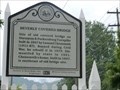
 view gallery view galleryW14.3 km | Beverly Covered Bridge in West Virginia Historical Markers A sign giving the history of the Beverly Covered Bridge. posted by: Paintedwarrior location: West Virginia date approved: 07/01/2013 last visited: 07/06/2013 |
 view gallery view galleryW14.3 km | Beverly Covered Bridge - Beverly WV in Signs of History Site of old covered bridge on Staunton & Parkersburg Turnpike built in 1847 by Lemuel Chenoweth (1811-87). posted by: Don.Morfe location: West Virginia date approved: 08/11/2020 last visited: 09/26/2021 |
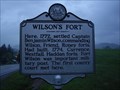 view gallery view galleryNW14.8 km | Wilson's Fort in West Virginia Historical Markers Wilson Fort built here in 1772, first county court met here. posted by: Paintedwarrior location: West Virginia date approved: 05/16/2013 last visited: 05/18/2013 |
|