 view gallery view gallery NE2.3 km NE2.3 km
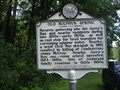
|   Old Sulphur Spring Old Sulphur Spring
in West Virginia Historical Markers A sign telling of what occurred near this rest stop for water. posted by:  Paintedwarrior Paintedwarrior location: West Virginia date approved: 07/28/2013 last visited: 08/01/2013 |
 view gallery view gallery SE2.7 km SE2.7 km
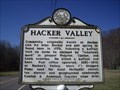
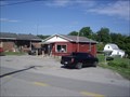
| Hacker Valley in West Virginia Historical Markers Information about the town of Hacker Valley posted by: Paintedwarrior location: West Virginia date approved: 03/12/2012 last visited: 03/16/2012 |
 view gallery view gallery N6 km N6 km
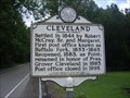
| Cleveland in West Virginia Historical Markers A sign with the same information on both sides telling us when the area was settled and how it received its name. posted by: Paintedwarrior location: West Virginia date approved: 07/28/2013 last visited: 08/01/2013 |
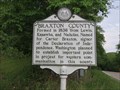
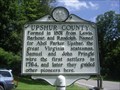 view gallery view galleryN6.4 km | Upshur / Webster County in West Virginia Historical Markers A two sided sign telling us when and from where the two counties where formed. posted by: Paintedwarrior location: West Virginia date approved: 07/28/2013 last visited: 08/01/2013 |
 view gallery view gallery SW10.3 km SW10.3 km
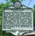
| Walter Cool in West Virginia Historical Markers A historical marker dedicated to the first sheriff of Webster County, located beside State Route 15, just north of Diana, WV. posted by: Cache Sleuth location: West Virginia date approved: 11/08/2009 last visited: 02/20/2012 |
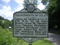 view gallery view galleryN13.8 km | Fort Pickens / Engagements of Co. A in West Virginia Historical Markers A two sided sign telling us how Fort Pickens came to be and the many battles that Company A was engaged in. posted by: Paintedwarrior location: West Virginia date approved: 07/28/2013 last visited: 08/01/2013 |
 view gallery view gallery NW15.6 km NW15.6 km
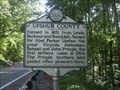
| Braxton County / Lewis County in West Virginia Historical Markers A sign telling us where the counties where formed from and who they were named after. posted by: Paintedwarrior location: West Virginia date approved: 06/01/2015 last visited: 06/02/2015 |
 view gallery view galleryN16.6 km |  Ireland WV 26376 Post Office Ireland WV 26376 Post Office
in U.S. Post Offices Ireland WV 26376 Post Office posted by: dukemartin location: West Virginia date approved: 07/25/2013 last visited: never |
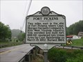 view gallery view galleryN16.9 km | Fort Pickens in West Virginia Historical Markers Tells where Fort Pickens is located. posted by: Paintedwarrior location: West Virginia date approved: 05/22/2015 last visited: 05/23/2015 |
 view gallery view gallery E17.7 km E17.7 km
| Helevetia WV 26224 Post Office in U.S. Post Offices Helevetia WV Post Office posted by: dukemartin location: West Virginia date approved: 06/12/2018 last visited: never |
 view gallery view galleryE17.7 km | Helvetia in West Virginia Historical Markers A sign describing the many skills the immigrants brought to this town. posted by: dukemartin location: West Virginia date approved: 06/05/2018 last visited: 06/05/2018 |
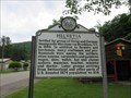 view gallery view galleryE17.9 km | Helvetia in West Virginia Historical Markers A sign describing the many skills the immigrants brought to this town. posted by: dukemartin location: West Virginia date approved: 06/05/2018 last visited: 06/05/2018 |
 view gallery view galleryN18 km | Upshur / Lewis County in West Virginia Historical Markers A two sided sign telling us when and from where the two counties were formed. posted by: Paintedwarrior location: West Virginia date approved: 07/28/2013 last visited: 08/01/2013 |
 view gallery view galleryN18.8 km | Rock Cave WV 26234 Post Office in U.S. Post Offices Rock Cave WV 26234 Post Office posted by: dukemartin location: West Virginia date approved: 07/25/2013 last visited: never |
 view gallery view galleryNW19.3 km |  Cunningham House-Bulltown Historic District - Napier WV Cunningham House-Bulltown Historic District - Napier WV
in Signs of History Named for Henry Cunningham, the Cunningham House was owned by the Cunningham family from the time it was built in the nineteenth century until 1976, when it was purchased by the U.S. Army Corps of Engineers. posted by:  Don.Morfe Don.Morfe location: West Virginia date approved: 11/19/2020 last visited: 09/24/2021 |
 view gallery view galleryNW19.3 km | Cunningham Farmstead-Bulltown Historic District - Napier WV in Signs of History In time the Cunninghams built a granary, barns, coal-and-wood house, outhouse, and chicken house, in addition to the main house, to form a traditional central West Virginia subsistence farm. posted by: Don.Morfe location: West Virginia date approved: 11/19/2020 last visited: 09/24/2021 |
 view gallery view galleryNW19.3 km | Spring House-Bulltown Historic District - Napier WV in Signs of History The main purpose of the spring house, which was built over a natural spring, was to provide a family with fresh, sanitary drinking water. The water was either pumped or dipped by hand, as needed. posted by: Don.Morfe location: West Virginia date approved: 11/19/2020 last visited: 09/24/2021 |
 view gallery view galleryNW19.3 km | Coal-and-Wood House-Bulltown Historic District - Napier WV in Signs of History The coal-and-wood house, a rectangular building constructed of rough saw-mill lumber, stood here. After the introduction of gas heating, the building was used for general storage. posted by: Don.Morfe location: West Virginia date approved: 11/19/2020 last visited: 09/24/2021 |
 view gallery view galleryNW19.3 km |  Battle of Bulltown-"Come and take us" - Napier WV Battle of Bulltown-"Come and take us" - Napier WV
in U.S. Civil War Sites On October 13, Confederate Col. William L. “Mudwall” Jackson attacked the fortifications at 4:30 A.M. with about 700 men of the 19th and 20 Virginia Cavalry and two guns of Capt. Warren S. Lurty’s battery. posted by: Don.Morfe location: West Virginia date approved: 07/05/2023 last visited: 07/05/2023 |
 view gallery view galleryNW19.3 km |  Battle of Bulltown - Napier WV Battle of Bulltown - Napier WV
in Battlefields On October 13, Confederate Col. William L. “Mudwall” Jackson attacked the fortifications at 4:30 A.M. with about 700 men of the 19th and 20 Virginia Cavalry and two guns of Capt. Warren S. Lurty’s battery. posted by: Don.Morfe location: West Virginia date approved: 11/21/2020 last visited: 10/16/2021 |
 view gallery view galleryNW19.3 km | Battle of Bulltown- "Come and take us" - Napier WV in Civil War Discovery Trail Sites On the hill in front of you are two fortifications that Union Gen. George B. McClellan ordered constructed late in1861. They guarded the wooden covered bridge located here on the Weston and Gauley Bridge Turnpike. posted by: Don.Morfe location: West Virginia date approved: 08/12/2020 last visited: 10/05/2021 |
 view gallery view galleryNW19.3 km | Bulltown / Bulltown Battle in West Virginia Historical Markers A two sided sign telling us about some battles that occurred near here. posted by: Paintedwarrior location: West Virginia date approved: 09/04/2013 last visited: 08/05/2014 |
 view gallery view galleryN19.3 km | Upshur Militia - Rock Cave WV in American Civil War Monuments and Memorials Marker is located on Ireland Rock Cave Road, Rock Cave WV. posted by: Don.Morfe location: West Virginia date approved: 09/02/2023 last visited: 09/02/2023 |
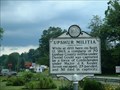 view gallery view galleryN19.3 km | Upshur Militia in West Virginia Historical Markers Upshur County militia posted by: two-bit Joe location: West Virginia date approved: 03/26/2011 last visited: 03/22/2023 |
 view gallery view galleryN19.3 km |  Upshur Militia - Rock Cave WV Upshur Militia - Rock Cave WV
in Specific Veteran Memorials While at drill here on Sept. 12, 1863, a company of 70 Upshur County militia under Daniel Gould was captured by a force of Confederates under Major J. K. Kesler. posted by: Don.Morfe location: West Virginia date approved: 03/24/2023 last visited: 03/22/2023 |
|